Smith Island, Maryland

Last updated

Smith Island, Maryland
Smith Island, Maryland (6632617567).jpg
Harbor at Ewell
Flag of Smith Island, Maryland.svg
Nickname: 
"The Rock"
Somerset County Maryland Incorporated and Unincorporated areas Smith Island Highlighted.svg
Coordinates: 37°59′N76°02′W / 37.983°N 76.033°W / 37.983; -76.033
CountryFlag of the United States.svg United States
State Flag of Maryland.svg  Maryland
County Flag of Somerset County, Maryland.svg Somerset
Area
[1]
  Total9.18 sq mi (23.77 km2)
  Land4.35 sq mi (11.27 km2)
  Water4.83 sq mi (12.50 km2)
Elevation
0 ft (0 m)
Population
 (2020)
  Total202
  Density46.44/sq mi (17.93/km2)
Time zone UTC−5 (Eastern (EST))
  Summer (DST) UTC−4 (EDT)
FIPS code 24-72887
GNIS feature ID1852600
Website www.visitsmithisland.com

Smith Island is a collection of three distinct island communities, Tylerton, Rhodes Point, and Ewell, Maryland on the Chesapeake Bay, on the border of Maryland and Virginia territorial waters in the United States. The island is the last inhabited island in Maryland that is not accessible by vehicle, where most of the islands are eroding due to tidal currents and sea level rise. A study conducted in 2008 by the DNR reported that Smith Island is expected to completely erode by 2100 if no action was taken. [2]

Contents

The island's population is approximately 220, [2] down from a peak of about 800. [3] On its Maryland side, Smith Island is a census-designated place (CDP) in Somerset County. It is included in the Salisbury, Maryland-Delaware Metropolitan Statistical Area.

Geography

Smith Island lies approximately 10 miles (16 km) west of Crisfield, Maryland, across the Tangier Sound portion of the Chesapeake Bay. The island consists of three communities, namely Ewell, Tylerton and Rhodes Point, which all sit on the Maryland portion of the island. The Virginia portion is uninhabited, although it once contained many homes of early settlers.[ citation needed ]

Although a portion of this island lies within Virginia, "Smith Island, Virginia" refers to a separate but identically named barrier island off Cape Charles.

Climate change and sea level rise

By the 2010s, the island had shrunk mainly due to erosion and rising sea levels. In the last 150 years, Smith Island has lost over 3,300 acres (13 km2) of wetlands. The island is projected to be completely eroded by 2100 should the sea level rise by another foot. [2] Preventative measures including a jetty-building project completed in 2018, and the realignment of waterways through dredging, were implemented in the hope to stop this. [4] These restoration efforts will be ongoing for the next 50 years to restore 1,900 acres (8 km2) of submerged aquatic vegetation and 240 acres (1 km2) of wetlands. [5] Moreover, the island is building additional coastal defenses. [2]

Demographics

Historical population
CensusPop.Note
2020 202
U.S. Decennial Census [6]

The community is located in a small town-area in the central part of the island, spread across the three inhabited locations of Ewell, Rhodes Point and Tylerton, all located in the state of Maryland. The northern part of Smith Island also includes the Martin National Wildlife Refuge. The southernmost portion of the island consisting of marsh lies in Accomack County, Virginia.[ citation needed ]

As of the 2010 Census, there were 276 people residing in the CDP. The population density was 81.7 inhabitants per square mile (31.5/km2). There were 218 housing units at an average density of 57.5 per square mile (22.2/km2). The racial makeup of the CDP was 99.6% White, 0.82% African American, 0.27% Native American, and 0.82% from two or more races. 51% of Smith Island's residents were English, 4% Greek, 3% Irish, 3% Scottish, and 3% French. [7]

There were 167 households, out of which 19.2% had children under the age of 18 living with them, 60.5% were married couples living together, 4.2% had a female householder with no husband present, and 32.9% were non-families. 29.3% of all households were made up of individuals, and 16.8% had someone living alone who was 65 years of age or older. The average household size was 2.18 and the average family size was 2.69.[ citation needed ]

In the CDP, the population was spread out, with 14.6% under the age of 18, 5.5% from 18 to 24, 22.3% from 25 to 44, 34.6% from 45 to 64, and 23.1% who were 65 years of age or older. The median age was 50 years. For every 100 females, there were 95.7 males. For every 100 females age 18 and over, there were 96.8 males.[ citation needed ]

The median income for a household in the CDP was $26,324, and the median income for a family was $29,375. Males had a median income of $26,250 versus $28,750 for females. The per capita income for the CDP was $25,469. About 14.4% of families and 37.8% of the population were below the poverty line, including 26.9% of those under age 18 and 67.9% of those age 65 or over.[ citation needed ]

Transportation

Smith Island has no airport and no bridges to the mainland; it can be accessed only by boat. [2] Passenger-only ferries connect Smith Island at Ewell to Point Lookout, Maryland, and Reedville, Virginia, on the Western shore of the Chesapeake Bay (seasonal) and from Crisfield, Maryland, on its Eastern Shore (year-round). A daily passenger ferry also runs between Crisfield, Maryland, and the smaller island of Tylerton, Maryland. [8]

Few motor vehicles exist on the islands, those of which are all on the northern community of Ewell and the connected Rhodes Point. Main modes of transportation for all three communities include golf carts as well as non-motorized transportation.[ citation needed ]

History and language

An 18-year-old male from Smith Island talking to a female interviewer about the erosion of Smith Island. (circa 1984)

The island was charted by John Smith. [3] British settlers arrived on the island in the 17th century, arriving from Cornwall, Wales, [9] and Dorset, England, via Virginia. [10] The island's population peaked at 800 in the 1900s. [3]

Smith Island is inhabited by one of the region's oldest English-speaking communities, which is known for its relic accent, preserving speech patterns from the original English colonial settlers. The local dialect is like the dialects of the West Country of England, including Cornwall. The dialect contains some relict features indicative of its origins. [11] The dialect is like the Ocracoke Brogue, [12] sometimes referred to as the Outer Banks Brogue. [13] [14]

The 1940 Maryland guide described a series of economic conflicts that characterized relationships between the inhabitants of Smith Island, the inhabitants of nearby Tangier Island, and agencies of the Federal government in the late 19th and early 20th centuries. For example, although 23,000 acres of rich oyster beds had been ceded from Maryland to Virginia in 1877,

the Smith Island men kept on dredging there for 50 years despite repeated attacks by Virginia patrol boats and inter-island battles in which oystermen on both sides were killed and wounded. The warfare ended only when the oysters in the area died ... Although killing wild ducks for market has been outlawed by Federal enactment since 1918, Smith Island remains a source of anxiety to the United States Biological Survey. Wardens risk their lives when drawn to the lonely island marshes by the deep booming of swivel guns mounted in sneak-boats—artillery that throws a pound of shot at a blast to kill and cripple ducks by the hundreds. To spot wire-enclosed duck traps, wardens in airplanes drop streamers of paper for the guidance of wardens in boats who attempt to make arrests, sometimes successfully, sometimes not. The islanders are sure that God has given them the ducks, oysters, fish, and crabs to take as they wish and they bitterly resent man-made game laws. [15]

Federal Writers'Project, "Part III: Touring the State", Maryland: A Guide to the Old Line State (1940)

The Island Belle , a former passenger ferry to the islands, was listed on the National Register of Historic Places in 1979. [16]

After the 2012 Hurricane Sandy, the Department of Housing and Community Development for the state of Maryland offered buyouts to landowners, most of whom refused the offer. [2]

Smith Island cake

Smith Island cake with fresh strawberries on the side Smith island cake2009.jpg
Smith Island cake with fresh strawberries on the side

Smith Island traditions include a region-specific cuisine, its most famous dish being the Smith Island cake, somewhat resembling the Prinzregententorte, with 8 to 15 thin layers [17] alternating with cooked chocolate frosting.[ citation needed ]

Beginning in the 1800s, Smith Islanders would send these cakes with the watermen on the autumn oyster harvest. The bakers began using fudge instead of buttercream frostings, as cakes frosted with fudge lasted much longer than cakes with other types of frosting. [18]

Scratch recipes typically involve evaporated milk, [19] while recipes based on commercial cake mixes add condensed milk. [20]

The most common recipes yield yellow cake with chocolate frosting, but other flavors variation include coconut, fig, strawberry, lemon, and orange. Smith Island cake is baked for any occasion, a dessert that needs no holiday. [21]

Smith Island cake is also baked as the feature prize for a local fundraising tradition called a cake walk, which is a game played like musical chairs where donated cakes serve as the prize. Great attention is paid to the perfection of the pencil-thin layers that form the distinctive cake. [22] Before each round, the prize Smith Island cake at stake is cut in half and shown to the players who pay to participate in the game. A poorly stacked Smith Island cake may not attract many players and as a result, not raise as much money as a more perfectly executed cake. [23]

Smith Island cake became the officially designated state dessert of Maryland on April 24, 2008. [24]

See also

Related Research Articles

<span class="mw-page-title-main">Chesapeake Bay</span> Estuary in the U.S. states of Maryland and Virginia

The Chesapeake Bay is the largest estuary in the United States. The Bay is located in the Mid-Atlantic region and is primarily separated from the Atlantic Ocean by the Delmarva Peninsula, including parts of the Eastern Shore of Maryland, the Eastern Shore of Virginia, and the state of Delaware. The mouth of the Bay at its southern point is located between Cape Henry and Cape Charles. With its northern portion in Maryland and the southern part in Virginia, the Chesapeake Bay is a very important feature for the ecology and economy of those two states, as well as others surrounding within its watershed. More than 150 major rivers and streams flow into the Bay's 64,299-square-mile (166,534 km2) drainage basin, which covers parts of six states, New York, Pennsylvania, Delaware, Maryland, Virginia, and West Virginia, and all of Washington, D.C.

<span class="mw-page-title-main">Somerset County, Maryland</span> County in Maryland, United States

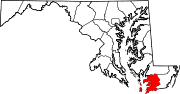
Somerset County is the southernmost county in the U.S. state of Maryland. As of the 2020 census, the population was 24,620, making it the second-least populous county in Maryland. The county seat is Princess Anne.

<span class="mw-page-title-main">Prince Frederick, Maryland</span> Census-designated place in Maryland, United States

Prince Frederick is an unincorporated community and census-designated place (CDP) in Calvert County, Maryland, United States. As of the 2020 census, the population of Prince Frederick was 3,226, up from 2,538 in 2010. It is the county seat of Calvert County.

<span class="mw-page-title-main">Crisfield, Maryland</span> City in Maryland, United States

Crisfield is a city in Somerset County, Maryland, United States, located on the Tangier Sound, an arm of the Chesapeake Bay. The population was 2,515 at the 2020 census. It is included in the Salisbury, Maryland-Delaware Metropolitan Statistical Area. Crisfield has the distinction of being the southernmost incorporated city in Maryland.

<span class="mw-page-title-main">Tilghman Island, Maryland</span> CDP in Maryland, United States

Tilghman Island is an island in the Chesapeake Bay. It is part of Talbot County, Maryland, United States.

<span class="mw-page-title-main">Saxis, Virginia</span> Town in Virginia, United States

Saxis is a town in Accomack County, Virginia, United States. The population was 241 at the 2010 census.

<span class="mw-page-title-main">Tangier, Virginia</span> Town and island in Chesapeake Bay, United States

Tangier is a town in Accomack County, Virginia, United States, on Tangier Island in Chesapeake Bay. The population was 727 at the 2010 census. Since 1850, the island's landmass has been reduced by 67%. Under the mid-range sea level rise scenario, much of the remaining landmass is expected to be lost in the next 50 years and the town will likely need to be abandoned.

<span class="mw-page-title-main">Wedding cake</span> Cake for a wedding

A wedding cake is the traditional cake served at wedding receptions following dinner. In some parts of England, the wedding cake is served at a wedding breakfast; the 'wedding breakfast' does not mean the meal will be held in the morning, but at a time following the ceremony on the same day. In modern Western culture, the cake is usually on display and served to guests at the reception. Traditionally, wedding cakes were made to bring good luck to all guests and the couple. Nowadays, however, they are more of a centerpiece to the wedding and are not always even served to the guests. Some cakes are built with only a single edible tier for the bride and groom to share, but this is rare since the cost difference between fake and real tiers is minimal.

<span class="mw-page-title-main">Chocolate brownie</span> Baked chocolate confection

A chocolate brownie, or simply a brownie, is a chocolate baked confection. Brownies come in a variety of forms and may be either fudgy or cakey, depending on their density. Brownies often, but not always, have a glossy "skin" on their upper crust. They may also include nuts, frosting, cream cheese, chocolate chips, or other ingredients. A variation made with brown sugar and vanilla rather than chocolate in the batter is called a blond brownie or blondie. The brownie was developed in the United States at the end of the 19th century and popularized there during the first half of the 20th century.

<span class="mw-page-title-main">Red velvet cake</span> Reddish chocolate cake with cream cheese icing

Red velvet cake is traditionally a red, crimson, or scarlet-colored layer cake, layered with ermine icing. Traditional recipes do not use food coloring, with the red color due to non-Dutched, anthocyanin-rich cocoa.

<span class="mw-page-title-main">Skipjack (boat)</span> Sailboat type used on Chesapeake Bay for oyster dredging.

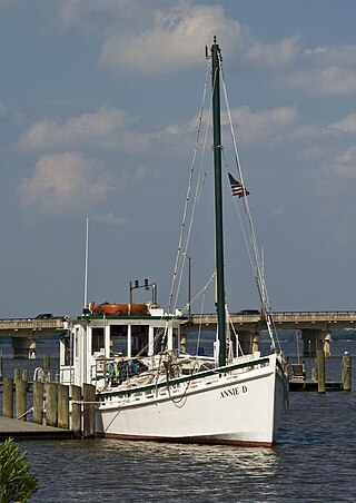
The skipjack is a traditional fishing boat used on the Chesapeake Bay for oyster dredging. It is a sailboat which succeeded the bugeye as the chief oystering boat on the bay, and it remains in service due to laws restricting the use of powerboats in the Maryland state oyster fishery.

<span class="mw-page-title-main">Dobos torte</span> Hungarian cake

Dobos torte, also known as Dobosh, is a Hungarian sponge cake layered with chocolate buttercream and topped with caramel. The layered pastry is named after its inventor, Hungarian chef József C. Dobos, a delicatessen owner in Budapest. In the late 1800s, he decided to create a cake that would last longer than other pastries in an age when cooling techniques were limited. The round sides of the cake are coated with ground hazelnuts, chestnuts, walnuts, or almonds, and the hardened caramel top helps to prevent drying out, for a longer shelf life.

<span class="mw-page-title-main">Maryland Route 413</span> State highway in Somerset County in Maryland, USA

Maryland Route 413 is a 14.61-mile (23.51 km) state highway in Somerset County in the U.S. state of Maryland. The route runs from a dead end at Crisfield's city dock, which is located on the Tangier Sound, northeast to U.S. Route 13 in Westover. It is the main highway leading into Crisfield, and is known as Crisfield Highway for much of its length. The highway travels through mostly rural areas of farms and woods as well as the communities of Hopewell, Marion Station, and Kingston. It is a two-lane undivided road for most of its length; a portion of the road in Crisfield is a four-lane road that follows a one-way pair. MD 413 is part of two scenic routes: Chesapeake Country Scenic Byway and the Beach to Bay Indian Trail; both are Maryland Scenic Byways.

<span class="mw-page-title-main">Prinzregententorte</span> Bavarian layer cake

Prinzregententorte is a Bavarian torte consisting of at least six, usually seven, thin layers of sponge cake interlaid with chocolate buttercream. The exterior is covered in a dark chocolate glaze. Prinzregententorte is very popular in Bavaria, Germany, and available in cake shops all year round.

<i>Nellie Crockett</i> United States historic place

The Nellie Crockett is a Chesapeake Bay oyster buy-boat built for Andrew A. Crockett of Tangier, Virginia, in 1925. She is located at Georgetown, Maryland, USA. She was designated a National Historic Landmark in 1994.

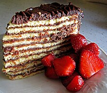
Tylerton is an unincorporated community located on Smith Island in Somerset County, Maryland, United States. Tylerton can be accessed via a ferry from Crisfield, Maryland. It is a waterman village of 50 residents. Attractions in the community include the Inn of Silent Music and The Drum Point Market, which sells beverages, homemade Smith Island cakes, crab cakes and other Chesapeake Bay specialties. The Chesapeake Bay Foundation's Smith Island Study Center is located in Tylerton.

Tangier Sound is a sound of the Chesapeake Bay bounded on the west by Tangier Island in Virginia, and Smith Island and South Marsh Island in Maryland, by Deal Island in Maryland on the north, and the mainland of the Eastern Shore of Maryland and Pocomoke Sound on the east. It stretches into Virginia as far south as Watts Island.

<span class="mw-page-title-main">Glenn Martin National Wildlife Refuge</span> Nature preserve in Maryland and Virginia

Glenn Martin National Wildlife Refuge includes the northern half of Smith Island, which lies 11 miles (18 km) west of Crisfield, Maryland, and Watts Island, which is located between the eastern shore of Virginia and Tangier Island. Both islands are situated in the lower Chesapeake Bay.

<span class="mw-page-title-main">Oyster buy-boat</span>

An oyster buy-boat, also known as deck boat, is an approximately 40–90 foot long wooden boat with a large open deck which serviced oyster tongers and dredgers. Similar in function to sardine carriers, buy boats circulated among the harvesters collecting their catches, then delivered their loads to a wholesaler or oyster processing house. This spared the fishermen the task and its downtime, allowing them to catch more oysters. Buy-boats also bought seed oysters, or spat, for planting in oyster beds.

<span class="mw-page-title-main">Cuisine of New Orleans</span> Culinary traditions of New Orleans, USA

The cuisine of New Orleans encompasses common dishes and foods in New Orleans, Louisiana. It is perhaps the most distinctively recognized regional cuisine in the United States. Some of the dishes originated in New Orleans, while others are common and popular in the city and surrounding areas, such as the Mississippi River Delta and southern Louisiana. The cuisine of New Orleans is heavily influenced by Creole cuisine, Cajun cuisine, and soul food. Seafood also plays a prominent part in the cuisine. Dishes invented in New Orleans include po' boy and muffuletta sandwiches, oysters Rockefeller and oysters Bienville, pompano en papillote, and bananas Foster, among others.

References

  1. "2020 U.S. Gazetteer Files". United States Census Bureau. Retrieved April 26, 2022.
  2. 1 2 3 4 5 6 Andrew Zaleski On 11/01/15 at 3:56 PM EST (November 1, 2015). "Smith Island Is Sinking Into the Chesapeake Bay Thanks to Climate Change". Newsweek . Retrieved January 3, 2021.
  3. 1 2 3 Dance, Scott. "At Smith Island, a chance to shore up the future". The Baltimore Sun . Retrieved January 3, 2021.
  4. "Officials Mark Completion of Jetties on Historic Smith Island".
  5. US Army Corps of Engineers Archived December 6, 2006, at the Wayback Machine Smith Island, Maryland Environmental Restoration and Protection Project Accessed October 11, 2007
  6. "Census of Population and Housing". Census.gov. Retrieved June 4, 2016.
  7. "Smith Island, MD, Ancestry & Family History". Epodunk.com. Archived from the original on April 17, 2015. Retrieved April 16, 2015.
  8. "How To Visit Smith Island Maryland". www.marylandrecommendations.com. Retrieved March 13, 2022.
  9. "Claws and effect". The Daily Telegraph. London. September 13, 2005. Archived from the original on November 22, 2016.
  10. Scheller, William G. (March 12, 2000). "Island of Calm". The Washington Post . Archived from the original on March 5, 2016. Retrieved December 11, 2012.
  11. Do You Speak American? by Robert MacNeil, William Cran, Robert McCrum. Page 35 Random House, Inc., 2005 ISBN   0-385-51198-1
  12. The North Carolina Language and Life Project Archived 2010-09-21 at the Wayback Machine Smith Island, MD. Accessed October 11, 2007
  13. Do You Speak American? by Robert MacNeil, William Cran, Robert McCrum. Page 34 Random House, Inc., 2005 ISBN   0-385-51198-1
  14. Hoi Toide on the Outer Banks by Walt Wolfram, Natalie Schilling-Estes, Page 156, UNC Press, 1997 ISBN   0-8078-4626-0
  15. Federal Writers' Project (1940). Maryland: A Guide to the Old Line State (1st ed.). New York: Oxford University Press. p. 438.
  16. "National Register Information System". National Register of Historic Places . National Park Service. July 9, 2010.
  17. Adventure Guide to the Chesapeake Bay by Barbara Radcliffe Rogers, Stillman Rogers page 435 Hunter Publishing, Inc, 2001 ISBN   1-55650-889-1
  18. smithislandcake.com Archived 2012-07-18 at the Wayback Machine The story behind our Smith Island Cakes. Accessed July 6, 2012.
  19. "Smith Island Layer Cake Recipe - Two Ways". VisitMaryland.org. Retrieved August 19, 2021.
  20. "How Maryland's Official State Cake Got its Stripes". Saveur.com. March 4, 2016. Retrieved February 12, 2019.
  21. Smith Island Layer Cake Archived 2007-09-29 at the Wayback Machine from Maryland Traditions
  22. smith island cake history Archived 2011-11-16 at the Wayback Machine from Original Smith Island Cake Company Website. Accessed October, 3o, 2011.
  23. An Island Out of Time: A Memoir of Smith Island in the Chesapeake by Tom Horton, Page 10 W. W. Norton & Company, 1996 ISBN   0-393-03938-2
  24. Smith Island Cake Now Maryland's Official Dessert Archived 2008-05-02 at the Wayback Machine from NewsChannel 8 1:38 pm Thu April 24, 2008 - ANNAPOLIS, Md. Accessed online April 26, 2008