Chance, Maryland

Last updated
Chance, Maryland
CDP
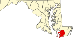
Somerset County Maryland Incorporated and Unincorporated areas Chance Highlighted.svg
Coordinates: 38°10′37″N75°56′21″W / 38.17694°N 75.93917°W / 38.17694; -75.93917 Coordinates: 38°10′37″N75°56′21″W / 38.17694°N 75.93917°W / 38.17694; -75.93917
CountryFlag of the United States.svg United States
State Flag of Maryland.svg  Maryland
County Flag of Somerset County, Maryland.svg Somerset
Area
[1]
  Total2.58 sq mi (6.69 km2)
  Land1.67 sq mi (4.32 km2)
  Water0.91 sq mi (2.37 km2)
Elevation
3 ft (1 m)
Population
 (2020)
  Total330
  Density197.60/sq mi (76.31/km2)
Time zone UTC−5 (Eastern (EST))
  Summer (DST) UTC−4 (EDT)
ZIP code
21821
Area code(s) 410
FIPS code 24-15075
GNIS feature ID0595203

Chance is a census-designated place (CDP) in Somerset County, Maryland, United States. The population was 377 at the 2000 census. It is included in the Salisbury, Maryland-Delaware Metropolitan Statistical Area.

Contents

History

The community took its name from the estate of the same name of an early settler. [2]

The Ida May and Rock Creek Methodist Episcopal Church are listed on the National Register of Historic Places. [3]

Geography

Chance is located at 38°10′37″N75°56′21″W / 38.17694°N 75.93917°W / 38.17694; -75.93917 (38.176818, 75.939272). [4]

According to the United States Census Bureau, the CDP has a total area of 2.6 square miles (6.7 km2), of which 1.7 square miles (4.4 km2) is land and 0.8 square miles (2.1 km2) (32.68%) is water.

Demographics

Historical population
CensusPop.
2020 330
U.S. Decennial Census [5]

As of the census [6] of 2000, there were 377 people, 161 households, and 113 families residing in the CDP. The population density was 218.1 people per square mile (84.1/km2). There were 254 housing units at an average density of 147.0/sq mi (56.7/km2). The racial makeup of the CDP was 75.60% White, 23.61% African American, 0.27% from other races, and 0.53% from two or more races. Hispanic or Latino of any race were 0.53% of the population.

There were 161 households, out of which 17.4% had children under the age of 18 living with them, 54.0% were married couples living together, 12.4% had a female householder with no husband present, and 29.2% were non-families. 23.6% of all households were made up of individuals, and 10.6% had someone living alone who was 65 years of age or older. The average household size was 2.34 and the average family size was 2.74.

In the CDP, the population was spread out, with 18.8% under the age of 18, 5.0% from 18 to 24, 24.1% from 25 to 44, 29.7% from 45 to 64, and 22.3% who were 65 years of age or older. The median age was 47 years. For every 100 females, there were 93.3 males. For every 100 females age 18 and over, there were 96.2 males.

The median income for a household in the CDP was $34,531, and the median income for a family was $37,969. Males had a median income of $25,469 versus $21,875 for females. The per capita income for the CDP was $15,706. About 16.8% of families and 23.2% of the population were below the poverty line, including 51.9% of those under age 18 and 14.3% of those age 65 or over.

Notable person

Related Research Articles

Edgemoor, Delaware CDP in Delaware, United States

Edgemoor is a census-designated place in New Castle County, Delaware, United States. The population was 5,677 at the 2010 census.

Country Club, Florida Census-designated place & Unincorporated community in Florida, United States

Country Club is a census-designated place and a suburban unincorporated community located in northwest Miami-Dade County, Florida, United States. It is named after the Country Club of Miami, which was established in 1961 in what was then an unpopulated and undeveloped section of the county. The population was 36,310 at the 2000 census.

Southchase, Florida Census-designated place in Florida, United States

Southchase is a census-designated place and an unincorporated area in Orange County, Florida, United States. The population was 15,921 at the 2010 census. It is part of the Orlando–Kissimmee–Sanford, Florida Metropolitan Statistical Area.

Dames Quarter, Maryland CDP in Maryland, United States

Dames Quarter is a census-designated place (CDP) in Somerset County, Maryland, United States. The population was 188 at the 2000 census. It is included in the Salisbury, Maryland-Delaware Metropolitan Statistical Area.

Fairmount, Maryland CDP in Maryland, United States

Fairmount is a census-designated place (CDP) in Somerset County, Maryland, United States. The population was 537 at the 2000 census. It is included in the Salisbury, Maryland-Delaware Metropolitan Statistical Area.

Frenchtown-Rumbly, Maryland CDP in Maryland, United States

Frenchtown-Rumbly is a census-designated place in Somerset County, Maryland, United States. The population was 96 at the 2000 census. It is included in the Salisbury, Maryland-Delaware Metropolitan Statistical Area.

Mount Vernon, Maryland CDP in Maryland, United States

Mount Vernon is a census-designated place (CDP) in Somerset County, Maryland, United States. The population was 761 at the 2000 census. It is included in the Salisbury, Maryland-Delaware Metropolitan Statistical Area.

West Pocomoke, Maryland CDP in Maryland, United States

West Pocomoke is a census-designated place (CDP) in Somerset County, Maryland, United States. The population was 498 at the 2000 census. It is included in the Salisbury, Maryland-Delaware Metropolitan Statistical Area.

West Ocean City, Maryland CDP in Maryland, United States

West Ocean City is a census-designated place (CDP) in Worcester County, Maryland, United States. The population was 4,375 at the 2010 census. It is part of the Salisbury, Maryland-Delaware Metropolitan Statistical Area.

Leach, Oklahoma Census-designated place in Oklahoma, United States

Leach is an unincorporated community and census-designated place (CDP) in southwestern Delaware County, Oklahoma, United States, along U.S. Route 412 and 412 Alternate. The population was 237 at the 2010 census.

Salix, Pennsylvania Census-designated place in Pennsylvania, United States

Salix is an unincorporated community and census-designated place (CDP) in Cambria County, Pennsylvania, United States. The population was 1,149 at the 2010 census. In previous censuses it was listed as Salix-Beauty Line Park.

Kenilworth, Pennsylvania Census-designated place in Pennsylvania, United States

Kenilworth is a census-designated place (CDP) in North Coventry Township, Chester County, Pennsylvania, United States. The population was 1,907 at the 2010 census.

South Pottstown, Pennsylvania Census-designated place in Pennsylvania, United States

South Pottstown is a community in North Coventry Township, Chester County in the U.S. state of Pennsylvania. It is defined by the U.S. Census Bureau as a census-designated place (CDP) for statistical purposes and does not have any legal status as a separately incorporated municipality. It is a part of the Pottstown urban area. The population was 2,081 at the 2010 census.

Black Lick is a census-designated place (CDP) in Burrell Township, Indiana County, Pennsylvania, United States. The population was 1,462 at the 2010 census.

Arlington Heights is a census-designated place (CDP) in Monroe County, Pennsylvania, United States. The population was 6,333 at the 2010 census. One notable location in Arlington Heights is the Stroud Mall.

Flourtown, Pennsylvania Census-designated place in Pennsylvania, United States

Flourtown is a census-designated place (CDP) in Springfield Township, Montgomery County, Pennsylvania, United States, with a ZIP code of 19031. Flourtown is adjacent to the neighborhoods of Erdenheim, Oreland, Whitemarsh, and Chestnut Hill. The population of Flourtown was 4,538 at the 2010 census.

Manchester Center, Vermont Census-designated place in Vermont, United States

Manchester Center is a census-designated place (CDP) in the town of Manchester in Bennington County, Vermont, United States. As of the 2010 census, the CDP had a population of 2,120, out of 4,391 people in the entire town of Manchester.

Lake Ketchum, Washington CDP in Washington, United States

Lake Ketchum is a census-designated place (CDP) in Snohomish County, Washington, United States. The population was 930 at the 2010 census.

Mineral Ridge, Ohio Census-designated place in Ohio, United States

Mineral Ridge is a census-designated place (CDP) in Mahoning and Trumbull counties in the U.S. state of Ohio. The population was 3,892 at the 2010 census. It is part of the Youngstown-Warren-Boardman, OH-PA Metropolitan Statistical Area.

Rumford is a census-designated place (CDP) in the town of Rumford in Oxford County, Maine, United States. The population was 4,795 at the 2000 census.

References

  1. "2020 U.S. Gazetteer Files". United States Census Bureau. Retrieved April 26, 2022.
  2. Moyer, Armond; Moyer, Winifred (1958). The origins of unusual place-names. Keystone Pub. Associates. p. 21.
  3. "National Register Information System". National Register of Historic Places . National Park Service. July 9, 2010.
  4. "US Gazetteer files: 2010, 2000, and 1990". United States Census Bureau. 2011-02-12. Retrieved 2011-04-23.
  5. "Census of Population and Housing". Census.gov. Retrieved June 4, 2016.
  6. "U.S. Census website". United States Census Bureau . Retrieved 2008-01-31.