Deal Island, Maryland

Last updated

Deal Island, Maryland
CDP
Deal Island Old Post Office.jpg
The old bank along MD 363 on Deal Island
Somerset County Maryland Incorporated and Unincorporated areas Deal Island Highlighted.svg
Coordinates: 38°9′16″N75°56′44″W / 38.15444°N 75.94556°W / 38.15444; -75.94556
CountryFlag of the United States.svg United States
State Flag of Maryland.svg  Maryland
County Flag of Somerset County, Maryland.svg Somerset
Area
[1]
  Total5.37 sq mi (13.91 km2)
  Land3.03 sq mi (7.85 km2)
  Water2.34 sq mi (6.05 km2)
Elevation
3 ft (0.9 m)
Population
 (2020)
  Total375
  Density123.72/sq mi (47.77/km2)
Time zone UTC−5 (Eastern (EST))
  Summer (DST) UTC−4 (EDT)
ZIP codes
21821, 21870
Area code 410
FIPS code 24-22100
GNIS feature ID0590074

Deal Island is a census-designated place (CDP) in Somerset County, Maryland, United States. The population was 375 [2] at the 2020 census. It is included in the Salisbury, Maryland-Delaware Metropolitan Statistical Area. The small town was listed on the National Register of Historic Places as the Deal Island Historic District in 2006. [3]

Contents

Geography

Deal Island is located at 38°9′16″N75°56′44″W / 38.15444°N 75.94556°W / 38.15444; -75.94556 (38.154551, 75.945659). [4]

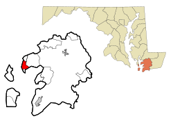
According to the United States Census Bureau, the CDP has a total area of 5.4 square miles (14 km2), of which 3.2 square miles (8.3 km2) is land and 2.1 square miles (5.4 km2) (39.66%) is water.

Deal Island is approximately 6 miles (9.7 km) to the west-southwest of Deal Island Wildlife Management Area.

Demographics

Historical population
CensusPop.Note
2020 375
U.S. Decennial Census [5]

As of the census [6] of 2020, there were 375 people, 240 households, and 165 families residing in the CDP. The population density was 178.0 inhabitants per square mile (68.7/km2). There were 352 housing units at an average density of 108.4 per square mile (41.9/km2). The racial makeup of the CDP was 90.31% White, 7.96% African American, 0.87% Native American, 0.17% from other races, and 0.69% from two or more races. Hispanic or Latino of any race were 1.21% of the population.

There were 240 households, out of which 20.0% had children under the age of 18 living with them, 57.1% were married couples living together, 7.9% had a female householder with no husband present, and 31.3% were non-families. 25.8% of all households were made up of individuals, and 13.3% had someone living alone who was 65 years of age or older. The average household size was 2.41 and the average family size was 2.94.

In the CDP, the population was spread out, with 21.3% under the age of 18, 5.7% from 18 to 24, 20.6% from 25 to 44, 33.6% from 45 to 64, and 18.9% who were 65 years of age or older. The median age was 65.1 years. For every 100 females, there were 100.0 males. For every 100 females age 18 and over, there were 97.8 males.

The median income for a household in the CDP was $36,029, and the median income for a family was $38,571. Males had a median income of $30,592 versus $24,219 for females. The per capita income for the CDP was $13,936. About 4.1% of families and 5.98% of the population were below the poverty line, including 7.7% of those under age 18 and 9.3% of those age 65 or over. [7]

History

Deal Island was historically known as Deal's, Deil's, and Devil's Island. Nearby Dames Quarters also had an unappealing name: Quarters of the Damned. At least one source also attributes these nicknames to the area's use by pirates.

Also the island is famous for Joshua Thomas, who predicted the British defeat in the War of 1812. Thomas is buried alongside the Joshua Thomas Chapel.

The Deal Island Historic District, Sea Gull (skipjack), and St. John's Methodist Episcopal Church and Joshua Thomas Chapel are listed on the National Register of Historic Places. [3]

Events

Since 1959, Deal Island has hosted an annual Labor Day weekend Skipjack Race. The race features skipjacks, which are traditional wooden sailing vessels with triangular sails, designed for dredging oysters. They are two-sail bateaux, and the term 'bateau' is still preferred by watermen. These vessels were operated extensively between the 1880s to the 1960s. Deal Island was once the home port for a large fleet of skipjacks and today has most of the few remaining skipjacks operating commercially for oystering on the Chesapeake Bay.

Also, during the Labor Day weekend, there is the annual Deal Island yard sale. It begins on Saturday and continues into Monday. Participants from other communities near Deal Island are also included.

Transportation

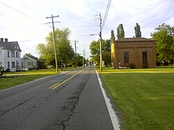
Deal Island's main road is Maryland Route 363; its entire length known as Deal Island Road. Route 363 traverses the entire island and travels due east to U.S. Route 13 in Princess Anne.

Deal Island's communities were once served by the Somerset Commuter (now Shore Transit), on Route 4, starting from Princess Anne's main transfer point. This route was removed in 2005.

Notable person

Related Research Articles

<span class="mw-page-title-main">Honalo, Hawaii</span> Census-designated place in Hawaii, U.S.

Honalo is a census-designated place (CDP) in Hawaiʻi County, Hawaiʻi, United States. The population was 2,423 at the 2010 census, up from 1,987 at the 2000 census.

<span class="mw-page-title-main">Mayo, Maryland</span> Census-designated place in Maryland, United States

Mayo is a census-designated place (CDP) in Anne Arundel County, Maryland, United States. The population was 8,298 at the 2010 census. The Mayo CDP of 2010 includes all of the area that used to be counted as the Selby-on-the-Bay CDP. The beach in Mayo used to be a popular weekend resort.

<span class="mw-page-title-main">Shady Side, Maryland</span> Census-designated place in Maryland, United States

Shady Side is a census-designated place (CDP) in Anne Arundel County, Maryland, United States. The population was 5,803 at the 2010 census.

<span class="mw-page-title-main">Owings, Maryland</span> Census-designated place in Maryland, United States

Owings is a town center and census-designated place (CDP) in northern Calvert County, Maryland, United States. The population was 2,149 at the 2010 census, up from 1,325 in 2000.

<span class="mw-page-title-main">Rosaryville, Maryland</span> Census-designated place in Maryland

Rosaryville is an unincorporated area and census-designated place (CDP) in Prince George's County, Maryland, United States, located south of Cinton and Upper Marlboro beside U.S. Route 301. Per the 2020 census, the population was 11,548. including housing developments and rural open space. It was named for a local Roman Catholic church. Close to Rosaryville are the Marlton housing development, Maryland Veterans Cemetery, the Southern Maryland Farmers Market, and Rosaryville State Park.

<span class="mw-page-title-main">Chance, Maryland</span> CDP in Maryland, United States

Chance is a census-designated place (CDP) in Somerset County, Maryland, United States. The population was 377 at the 2000 census. It is included in the Salisbury, Maryland-Delaware Metropolitan Statistical Area.

<span class="mw-page-title-main">Dames Quarter, Maryland</span> CDP in Maryland, United States

Dames Quarter is a census-designated place (CDP) in Somerset County, Maryland, United States. The population was 188 at the 2000 census. It is included in the Salisbury, Maryland-Delaware Metropolitan Statistical Area.

<span class="mw-page-title-main">Eden, Maryland</span> CDP in Maryland, United States

Eden is a census-designated place (CDP) in Somerset County, Maryland, United States. The Eden zip code (21822) also includes parts of Wicomico and Worcester counties. The population was 793 at the 2000 census. It is included in the Salisbury, Maryland-Delaware Metropolitan Statistical Area.

<span class="mw-page-title-main">Fairmount, Maryland</span> CDP in Maryland, United States

Fairmount is a census-designated place (CDP) in Somerset County, Maryland, United States. The population was 537 at the 2000 census. It is included in the Salisbury, Maryland-Delaware Metropolitan Statistical Area.

<span class="mw-page-title-main">Mount Vernon, Maryland</span> CDP in Maryland, United States

Mount Vernon is a census-designated place (CDP) in Somerset County, Maryland, United States. The population was 761 at the 2000 census. It is included in the Salisbury, Maryland-Delaware Metropolitan Statistical Area.

<span class="mw-page-title-main">West Pocomoke, Maryland</span> CDP in Maryland, United States

West Pocomoke is a census-designated place (CDP) in Somerset County, Maryland, United States. The population was 498 at the 2000 census. It is included in the Salisbury, Maryland-Delaware Metropolitan Statistical Area.

<span class="mw-page-title-main">Charlotte Hall, Maryland</span> CDP in Maryland, United States

Charlotte Hall is a census-designated place (CDP) in Charles and St. Mary's counties, Maryland, United States. The population was 1,420 at the 2010 census. The Maryland Veterans Home for disabled veterans, including a U.S. Veterans Affairs clinic, is located on the site of the former Charlotte Hall Military Academy. The Academy site was declared the Charlotte Hall Historic District, and listed on the National Register of Historic Places in 1975. Since 1940, a sizable Amish farming community has existed nearby, along with a farmers' market and large flea market complex on Maryland Route 5, which is also the site of numerous strip-mall businesses continuing into the adjacent community of Mechanicsville.

<span class="mw-page-title-main">Tilghman Island, Maryland</span> CDP in Maryland, United States

Tilghman Island is an island in the Chesapeake Bay. It is part of Talbot County, Maryland, United States.

<span class="mw-page-title-main">Girdletree, Maryland</span> CDP in Maryland, United States

Girdletree is a census-designated place in Worcester County, Maryland, United States. The population was 149 at the 2010 census. It is part of the Salisbury, Maryland-Delaware Metropolitan Statistical Area.

<span class="mw-page-title-main">Newark, Maryland</span> CDP in Maryland, United States

Newark is a census-designated place (CDP) in Worcester County, Maryland, United States. The population was 339 at the 2000 census. It is part of the Salisbury, Maryland-Delaware Metropolitan Statistical Area.

<span class="mw-page-title-main">Stockton, Maryland</span> CDP in Maryland, United States

Stockton is a census-designated place (CDP) in Worcester County, Maryland, United States. The population was 92 at the 2010 census. It is part of the Salisbury, Maryland-Delaware Metropolitan Statistical Area.

<span class="mw-page-title-main">West Ocean City, Maryland</span> CDP in Maryland, United States

West Ocean City is a census-designated place (CDP) in Worcester County, Maryland, United States. The population was 4,375 at the 2010 census. It is part of the Salisbury, Maryland-Delaware Metropolitan Statistical Area.

<span class="mw-page-title-main">Whaleyville, Maryland</span> CDP in Maryland, United States

Whaleyville is a census-designated place in Worcester County, Maryland, United States. The population was 149 at the 2010 census. It is part of the Salisbury, Maryland-Delaware Metropolitan Statistical Area.

<span class="mw-page-title-main">Pinewood Estates, Texas</span> Census-designated place in Texas, United States

Pinewood Estates is an unincorporated community and census-designated place (CDP) in Hardin County, Texas, United States. The population was 1,678 at the 2010 census. It is part of the Beaumont–Port Arthur Metropolitan Statistical Area.

Bridgeport is a hamlet located partly in the town of Sullivan in Madison County, New York, United States and partly in the town of Cicero in Onondaga County. The population was 1,490 at the 2010 census.

References

  1. "2020 U.S. Gazetteer Files". United States Census Bureau. Retrieved April 26, 2022.
  2. "Deal Island Demographics - Get Current Census Data for Deal Island, MD". www.maryland-demographics.com. Retrieved March 29, 2022.
  3. 1 2 "National Register Information System". National Register of Historic Places . National Park Service. April 15, 2008.
  4. "US Gazetteer files: 2010, 2000, and 1990". United States Census Bureau. February 12, 2011. Retrieved April 23, 2011.
  5. "Census of Population and Housing". Census.gov. Retrieved June 4, 2016.
  6. "U.S. Census website". United States Census Bureau . Retrieved January 31, 2008.
  7. "Deal Island, MD | Data USA". datausa.io. Retrieved March 29, 2022.
  8. Dickinson College Archives and Special Collections-William Daniel