James City, North Carolina

Last updated

James City, North Carolina
NCMap-doton-JamesCity.PNG
Location of James City, North Carolina
Coordinates: 35°03′24″N77°00′31″W / 35.05667°N 77.00861°W / 35.05667; -77.00861
Country United States
State North Carolina
County Craven
Area
[1]
  Total13.81 sq mi (35.76 km2)
  Land7.71 sq mi (19.97 km2)
  Water6.10 sq mi (15.79 km2)
Elevation
[2]
23 ft (7 m)
Population
 (2020)
  Total5,291
  Density686.16/sq mi (264.93/km2)
Time zone UTC-5 (Eastern (EST))
  Summer (DST) UTC-4 (EDT)
FIPS code 37-34260 [3]
GNIS feature ID2402629 [2]

James City is an unincorporated area and census-designated place (CDP) in Craven County, North Carolina, United States. The population was 5,899 at the 2010 census. [4] It is part of the New Bern, North Carolina Metropolitan Statistical Area.

Contents

History

James City was developed during the American Civil War when Union forces, occupying nearby New Bern, constructed a resettlement camp for freed slaves on land belonging to Confederate Army Colonel Peter G. Evans. Originally referred to as the Trent River Settlement, by 1865 it had been renamed James City, after its founder, Union Army chaplain Horace James, superintendent of Negro affairs and agent for the Bureau of Freedmen, Refugees, and Abandoned Lands. [5]

Geography

Aerial photo of New Bern (center left) and James City (center to lower right). East is up. Neuse River Bridge.jpeg
Aerial photo of New Bern (center left) and James City (center to lower right). East is up.

James City is located in central Craven County along the west bank of the tidal Neuse River. It is bordered to the north by the city of New Bern, the county seat, across the Trent River, a tributary of the Neuse. To the west are the unincorporated community of Brices Creek, and a more recently annexed portion of New Bern. Coastal Carolina Regional Airport is in the northwestern part of the CDP.

According to the United States Census Bureau, James City has a total area of 13.9 square miles (35.9 km2), of which 7.6 square miles (19.7 km2) is land and 6.3 square miles (16.3 km2), or 45.34%, is water. [4]

Demographics

Historical population
CensusPop.Note
2020 5,291
U.S. Decennial Census [6]

2020 census

James City racial composition [7]
RaceNumberPercentage
White (non-Hispanic)3,91974.07%
Black or African American (non-Hispanic)71313.48%
Native American 80.15%
Asian 470.89%
Pacific Islander 50.09%
Other/Mixed 2504.73%
Hispanic or Latino 3496.6%

As of the 2020 United States census, there were 5,291 people, 2,144 households, and 1,475 families residing in the CDP.

2000 census

As of the census [3] of 2000, there were 5,420 people, 2,184 households, and 1,530 families residing in the CDP. The population density was 651.5 inhabitants per square mile (251.5/km2). There were 2,397 housing units at an average density of 288.1 per square mile (111.2/km2). The racial makeup of the CDP was 78.91% White, 18.14% African American, 0.24% Native American, 0.48% Asian, 0.02% Pacific Islander, 1.03% from other races, and 1.18% from two or more races. Hispanic or Latino of any race were 1.96% of the population.

There were 2,184 households, out of which 30.9% had children under the age of 18 living with them, 54.8% were married couples living together, 12.0% had a female householder with no husband present, and 29.9% were non-families. 25.1% of all households were made up of individuals, and 8.1% had someone living alone who was 65 years of age or older. The average household size was 2.44 and the average family size was 2.90.

In the CDP, the population was spread out, with 24.6% under the age of 18, 7.9% from 18 to 24, 29.6% from 25 to 44, 23.5% from 45 to 64, and 14.4% who were 65 years of age or older. The median age was 38 years. For every 100 females, there were 94.2 males. For every 100 females age 18 and over, there were 90.0 males.

The median income for a household in the CDP was $36,490, and the median income for a family was $45,410. Males had a median income of $31,021 versus $21,859 for females. The per capita income for the CDP was $18,635. About 9.6% of families and 13.5% of the population were below the poverty line, including 22.9% of those under age 18 and 11.2% of those age 65 or over.

Related Research Articles

<span class="mw-page-title-main">Pamlico County, North Carolina</span> County in North Carolina, United States

PamlicoCounty is a county located in the U.S. state of North Carolina. At the 2020 census, the population was 12,276. In 2022, the population was estimated to be 12,381, making it the tenth-least populous county in North Carolina. Its county seat is Bayboro.

<span class="mw-page-title-main">Craven County, North Carolina</span> County in North Carolina, United States

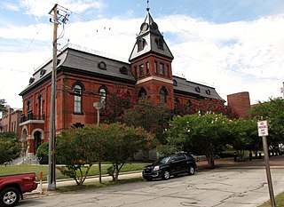
Craven County is located in the U.S. state of North Carolina. As of the 2020 census, the population was 100,720. Its county seat is New Bern. The county was created in 1705 as Archdale Precinct from the now-extinct Bath County. It was renamed Craven Precinct in 1712 and gained county status in 1739. It is named for William, Earl of Craven, who lived from 1606 to 1697. Craven County is part of the New Bern, NC Micropolitan Statistical Area.

<span class="mw-page-title-main">Sherwood Manor, Connecticut</span> Census-designated place in Connecticut, United States

Sherwood Manor is a census-designated place (CDP) within the town of Enfield in Hartford County, Connecticut, United States. The population was 5,410 at the 2010 census.

<span class="mw-page-title-main">Altamahaw, North Carolina</span> Census-designated place in North Carolina, United States

Altamahaw is a census-designated place (CDP) in Alamance County, North Carolina, United States. It is part of the Burlington, North Carolina Metropolitan Statistical Area. As of the 2010 census it had a population of 347. The community was listed as Altamahaw-Ossipee at the 2000 census, at which time the population was 996. The town of Ossipee incorporated in 2002 and currently has a population of 543. The remainder of the territory was reassigned as the Altamahaw CDP.

<span class="mw-page-title-main">St. Stephens, North Carolina</span> Census-designated place in North Carolina, United States

St. Stephens is a census-designated place (CDP) in Catawba County, North Carolina, United States. The population was 8,759 at the 2010 census, down from 9,439 in 2000. It is part of the Hickory–Lenoir–Morganton Metropolitan Statistical Area.

Brices Creek is an unincorporated area and census-designated place (CDP) in Craven County, North Carolina, United States. The population was 3,073 at the 2010 census. It is part of the New Bern, North Carolina Metropolitan Statistical Area.

<span class="mw-page-title-main">Bridgeton, North Carolina</span> Town in North Carolina, United States

Bridgeton is a town in Craven County, North Carolina, United States. The population was 454 at the 2010 census. It is part of the New Bern, North Carolina Micropolitan Statistical Area.

<span class="mw-page-title-main">Cove City, North Carolina</span> Town in North Carolina, United States

Cove City is a town in Craven County, North Carolina, United States. The population was 378 at the 2020 U.S. census. It is part of the New Bern, North Carolina Micropolitan Statistical Area.

<span class="mw-page-title-main">Fairfield Harbour, North Carolina</span> Census-designated place in North Carolina, United States

Fairfield Harbour is an unincorporated community and census-designated place (CDP) in Craven County, North Carolina, United States. The population was 2,952 at the 2010 census, up from 1,983 in 2000. It is part of the New Bern, North Carolina Metropolitan Statistical Area.

<span class="mw-page-title-main">Havelock, North Carolina</span> City in North Carolina, United States

Havelock is a city in Craven County, North Carolina, United States. The population was 20,735 at the 2010 census. The city is home to Marine Corps Air Station Cherry Point, the world's largest Marine Corps air station, and home to the 2nd Marine Aircraft Wing.

<span class="mw-page-title-main">Neuse Forest, North Carolina</span> Census-designated place in North Carolina, United States

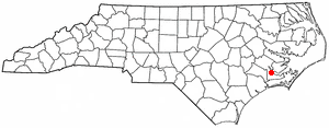
Neuse Forest is a census-designated place (CDP) in Craven County, North Carolina, United States. The population was 2,005 at the 2010 census. It is part of the New Bern, North Carolina Metropolitan Statistical Area.

<span class="mw-page-title-main">River Bend, North Carolina</span> Town in North Carolina, United States

River Bend is a town in Craven County, North Carolina, United States. The population was 3,119 as of the 2010 census. It is part of the New Bern, North Carolina Metropolitan Statistical Area.

<span class="mw-page-title-main">Gorman, North Carolina</span> Census-designated place in North Carolina, United States

Gorman is a census-designated place (CDP) in Durham County, North Carolina, United States. The population was 1,011 at the 2010 census.

<span class="mw-page-title-main">West Smithfield, North Carolina</span> Former census-designated place in North Carolina, United States

West Smithfield was an unincorporated community and census-designated place and is now a district of Smithfield, North Carolina in Johnston County, North Carolina, United States. The population was last recorded separately from Smithfield in 2000, when 59 people resided in the CDP.

<span class="mw-page-title-main">Boger City, North Carolina</span> Neighborhood in Lincoln, North Carolina, United States

Boger City is a neighborhood of the city of Lincolnton in Lincoln County, North Carolina, United States. The population was 554 at the 2000 census, at which time it was erroneously listed as a census-designated place.

<span class="mw-page-title-main">Gantt, South Carolina</span> Census-designated place in South Carolina, United States

Gantt is a census-designated place (CDP) in Greenville County, South Carolina, United States. The population was 14,229 at the 2010 census. It is part of the Greenville–Mauldin–Easley Metropolitan Statistical Area and a suburb of the city of Greenville.

Parker is a census-designated place (CDP) in Greenville County, South Carolina, United States. The population was 11,431 at the 2010 census, up from 10,760 in 2000. It is part of the Greenville–Mauldin–Easley Metropolitan Statistical Area.

Wade Hampton is a census-designated place (CDP) in Greenville County, South Carolina, United States. The population was 20,622 at the 2010 census. It is named for American Civil War general and South Carolina governor Wade Hampton.

<span class="mw-page-title-main">Red Hill, South Carolina</span> Census-designated place in South Carolina, United States

Red Hill is a census-designated place (CDP) in Horry County, South Carolina, United States. The population was 13,223 at the 2010 census, up from 10,509 at the 2000 census.

<span class="mw-page-title-main">Ladson, South Carolina</span> Census-designated place in South Carolina, United States

Ladson is a census-designated place (CDP) in Berkeley, Charleston and Dorchester counties in the U.S. state of South Carolina. The population was 13,790 at the 2010 census. It is named in honor of the Ladson family, one of the oldest planter and merchant families in the Charleston area; one of its members was lieutenant governor James Ladson.

References

  1. "ArcGIS REST Services Directory". United States Census Bureau. Retrieved September 20, 2022.
  2. 1 2 U.S. Geological Survey Geographic Names Information System: James City, North Carolina
  3. 1 2 "U.S. Census website". United States Census Bureau . Retrieved January 31, 2008.
  4. 1 2 "Geographic Identifiers: 2010 Demographic Profile Data (G001): James City CDP, North Carolina". U.S. Census Bureau, American Factfinder. Archived from the original on February 12, 2020. Retrieved January 5, 2015.
  5. Zipf, Karin Lorene. "James City". NCpedia. State Library of North Carolina. Retrieved January 30, 2016.
  6. "Census of Population and Housing". Census.gov. Retrieved June 4, 2016.
  7. "Explore Census Data". data.census.gov. Retrieved December 24, 2021.