Alliance, North Carolina

Last updated

Alliance, North Carolina
NCMap-doton-Alliance.PNG
Location of Alliance, North Carolina
Coordinates: 35°08′37″N76°48′30″W / 35.14361°N 76.80833°W / 35.14361; -76.80833 [1]
Country United States
State North Carolina
County Pamlico
Area
[2]
  Total2.09 sq mi (5.40 km2)
  Land2.09 sq mi (5.40 km2)
  Water0.00 sq mi (0.00 km2)
Elevation
[1]
0 ft (0 m)
Population
 (2020)
  Total733
  Density351.39/sq mi (135.66/km2)
Time zone UTC-5 (Eastern (EST))
  Summer (DST) UTC-4 (EDT)
ZIP code
28509
Area code 252
FIPS code 37-01000 [3]
GNIS feature ID2405137 [1]

Alliance is a town in Pamlico County, North Carolina, United States. Its name is derived from the Farmers Alliance Movement from around 1874, two years after Pamlico was founded. Alliance was incorporated in 1965. The majority of land in Alliance is farmland. The population was 776 at the 2010 census. It is part of the New Bern, North Carolina Micropolitan Statistical Area.

Contents

Geography

According to the United States Census Bureau, the town has a total area of 2.0 square miles (5.2 km2), all land.

Demographics

Historical population
CensusPop.Note
1970 577
1980 6166.8%
1990 583−5.4%
2000 78134.0%
2010 776−0.6%
2020 733−5.5%
2022 (est.)731 [4] −0.3%
U.S. Decennial Census [5]

2020 census

Alliance racial composition [6]
RaceNumberPercentage
White (non-Hispanic)55675.85%
Black or African American (non-Hispanic)12316.78%
Native American 10.14%
Asian 50.68%
Pacific Islander 10.14%
Other/Mixed 192.59%
Hispanic or Latino 283.82%

As of the 2020 United States census, there were 733 people, 340 households, and 216 families residing in the town.

2000 census

As of the census [3] of 2000, there were 781 people, 288 households, and 201 families residing in the town. The population density was 389.5 inhabitants per square mile (150.4/km2). There were 304 housing units at an average density of 151.6 per square mile (58.5/km2). The racial makeup of the town was 79.64% White, 17.67% African American, 1.15% Native American, 0.51% Asian, 0.26% from other races, and 0.77% from two or more races. Hispanic or Latino people of any race were 0.77% of the population.

There were 288 households, out of which 26.4% had children under the age of 18 living with them, 55.6% were married couples living together, 10.8% had a female householder with no husband present, and 30.2% were non-families. 27.1% of all households were made up of individuals, and 11.1% had someone living alone who was 65 years of age or older. The average household size was 2.40 and the average family size was 2.93.

In the town, the population was spread out, with 22.5% under the age of 18, 5.5% from 18 to 24, 24.5% from 25 to 44, 22.8% from 45 to 64, and 24.7% who were 65 years of age or older. The median age was 43 years. For every 100 females, there were 83.3 males. For every 100 females age 18 and over, there were 77.4 males.

The median income for a household in the town was $26,719, and the median income for a family was $35,250. Males had a median income of $33,125 versus $22,438 for females. The per capita income for the town was $15,951. About 12.1% of families and 17.3% of the population were below the poverty line, including 28.4% of those under age 18 and 16.8% of those age 65 or over.

Related Research Articles

<span class="mw-page-title-main">Pamlico County, North Carolina</span> County in North Carolina, United States

PamlicoCounty is a county located in the U.S. state of North Carolina. As of the 2020 census, the population was 12,276. Its county seat is Bayboro.

<span class="mw-page-title-main">Beaufort County, North Carolina</span> County in North Carolina, United States

Beaufort County is a county located in the U.S. state of North Carolina. As of the 2020 census, the population was 44,652. Its county seat is Washington. The county was founded in 1705 as Pamptecough Precinct. Originally included in Bath County, it was renamed Beaufort Precinct in 1712 and became Beaufort County in 1739.

Bradford is a town in Steuben County, New York, United States. The population was 811 at the 2020 census. The town is named after Major Robert Bradford, and is located in the northeastern section of the county, north of Corning.

<span class="mw-page-title-main">Aurora, North Carolina</span> Town in North Carolina, United States

Aurora is a town in Beaufort County, North Carolina, United States. The population was 520 at the 2010 Census.

River Road is a census-designated place (CDP) in Beaufort County, North Carolina, United States. The population was 4,048 at the 2020 Census.

<span class="mw-page-title-main">Washington, North Carolina</span> City in North Carolina, United States

Washington is a city in Beaufort County, North Carolina, United States, located on the northern bank of the Pamlico River. The population was 9,875 at the 2020 census. It is the county seat of Beaufort County. It is commonly known as "Original Washington" or "Little Washington" to distinguish it from Washington, D.C. The closest major city is Greenville, approximately 20 miles (32 km) to the west.

<span class="mw-page-title-main">East Arcadia, North Carolina</span> Town in North Carolina, United States

East Arcadia is a town in Bladen County, North Carolina, United States. The population was 487 at the 2010 census.

<span class="mw-page-title-main">Bayboro, North Carolina</span> Town in North Carolina, United States

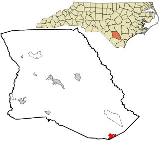
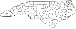
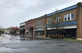
Bayboro is a town in Pamlico County, North Carolina, United States. The population was 1,161 at the 2020 U.S. census. It is the county seat of Pamlico County.

<span class="mw-page-title-main">Mesic, North Carolina</span> Town in North Carolina, United States

Mesic is a town in Pamlico County, North Carolina, United States. The population was 220 at the 2010 census. It is part of the New Bern, North Carolina Micropolitan Statistical Area.

<span class="mw-page-title-main">Minnesott Beach, North Carolina</span> Town in North Carolina, United States

Minnesott Beach is a town in Pamlico County, North Carolina, United States. The population was 440 at the 2010 census. It is part of the New Bern, North Carolina Metropolitan Statistical Area.

<span class="mw-page-title-main">Stonewall, North Carolina</span> Town in North Carolina, United States

Stonewall is a town in Pamlico County, North Carolina, United States. The population was 281 at the 2010 census. It is part of the New Bern, North Carolina Micropolitan Statistical Area.

Vandemere is a town in Pamlico County, North Carolina, United States. As of the 2010 census, the town population was 254. It is part of the New Bern, North Carolina Micropolitan Statistical Area.

<span class="mw-page-title-main">Columbia, North Carolina</span> Town in North Carolina, United States

Columbia is a town in Tyrrell County, North Carolina, United States. The population was 610 at the 2020 census. It is the county seat of Tyrrell County.

<span class="mw-page-title-main">Creswell, North Carolina</span> Town in North Carolina, United States

Creswell is a town in Washington County, North Carolina, United States. The population was 207 at the 2020 census.

<span class="mw-page-title-main">Hamilton Township, McKean County, Pennsylvania</span> Township in Pennsylvania, United States

Hamilton Township is a township in McKean County, Pennsylvania, United States. The population was 553 at the 2020 census.

<span class="mw-page-title-main">Lowndesville, South Carolina</span> Town in South Carolina, United States

Lowndesville is a town in Abbeville County, South Carolina. The population was 120 at the 2020 census.

<span class="mw-page-title-main">St. Stephen, South Carolina</span> Town in South Carolina, United States

St. Stephen is a town in Berkeley County, South Carolina, United States. The population was 1,697 at the 2010 census.

Springdale is a town in Lexington County, South Carolina, United States. The population was 2,636 at the 2010 census. It is part of the Columbia Metropolitan Statistical Area.

<span class="mw-page-title-main">Eastover, South Carolina</span> Town in South Carolina, United States

Eastover is a town in Richland County, South Carolina, United States. The population was 813 at the 2010 census, down from 830 in 2000. It is part of the Columbia, South Carolina, Metropolitan Statistical Area.

<span class="mw-page-title-main">Sharpsburg, North Carolina</span> Town in North Carolina, United States

Sharpsburg is a town in Edgecombe, Nash, and Wilson counties, North Carolina, United States. It is part of the Rocky Mount, North Carolina Metropolitan Statistical Area. The population was 2,024 at the 2010 Census.

References

  1. 1 2 3 U.S. Geological Survey Geographic Names Information System: Alliance, North Carolina
  2. "ArcGIS REST Services Directory". United States Census Bureau. Retrieved September 20, 2022.
  3. 1 2 "U.S. Census website". United States Census Bureau . Retrieved January 31, 2008.
  4. "Annual Estimates of the Resident Population for Incorporated Places in North Carolina: April 1, 2020 to July 1, 2022". Census.gov. Retrieved April 19, 2024.
  5. "Census of Population and Housing". Census.gov. Retrieved June 4, 2015.
  6. "Explore Census Data". data.census.gov. Retrieved December 23, 2021.