Autryville | |
|---|---|
 Downtown Autryville | |
 Seal | |
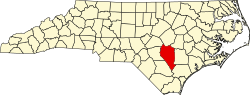
 Autryville Location within the state of North Carolina | |
| Coordinates: 34°59′47″N78°38′28″W / 34.99639°N 78.64111°W | |
| Country | |
| State | |
| County | Sampson |
| Incorporated | 1891 |
| Government | |
| • Mayor | Grayson Spell |
| • Town Clerk | Lisa Jones |
| Area | |
• Total | 0.52 sq mi (1.35 km2) |
| • Land | 0.52 sq mi (1.35 km2) |
| • Water | 0.00 sq mi (0.00 km2) |
| Elevation | 112 ft (34 m) |
| Population (2020) | |
• Total | 167 |
| • Density | 319.92/sq mi (123.41/km2) |
| Time zone | UTC-5 (Eastern (EST)) |
| • Summer (DST) | UTC-4 (EDT) |
| ZIP code | 28318 |
| Area codes | 910, 472 |
| FIPS code | 37-02700 [3] |
| GNIS feature ID | 2405188 [2] |
Autryville is a town in Sampson County, North Carolina, United States. The population was 167 at the 2020 census. The town is located in western Sampson County along the banks of the South River, adjacent to Cumberland County. Autryville is governed by a mayor and a five-member town commission. The town is about 15 miles east-southeast of Fayetteville, along North Carolina Highway 24.