Keener, North Carolina

Last updated

Keener, North Carolina
CDP
USA North Carolina location map.svg
Red pog.svg
Keener, North Carolina
Location within the state of North Carolina
Coordinates: 35°06′47″N78°18′34″W / 35.11306°N 78.30944°W / 35.11306; -78.30944
Country United States
State North Carolina
County Sampson
Area
[1]
  Total11.18 sq mi (28.96 km2)
  Land11.17 sq mi (28.94 km2)
  Water0.01 sq mi (0.02 km2)
Elevation
[2]
171 ft (52 m)
Population
 (2020)
  Total540
  Density48.33/sq mi (18.66/km2)
Time zone UTC-5 (Eastern (EST))
  Summer (DST) UTC-4 (EDT)
ZIP code
28328 [3]
Area codes 910, 472
FIPS code 37-35340 [4]
GNIS feature ID2403165 [2]

Keener is a census-designated place (CDP) in Sampson County, North Carolina, United States. The population was 540 at the 2020 census.

Contents

Geography

According to the United States Census Bureau, the CDP has a total area of 11.2 square miles (29 km2), all land.

Demographics

Historical population
CensusPop.Note
2020 540
U.S. Decennial Census [5]

As of the census [4] of 2000, there were 508 people, 206 households, and 149 families residing in the CDP. The population density was 45.5 inhabitants per square mile (17.6/km2). There were 241 housing units at an average density of 21.6/sq mi (8.3/km2). The racial makeup of the CDP was 71.26% White, 25.59% African American, 0.39% Native American, 2.56% from other races, and 0.20% from two or more races. Hispanic or Latino of any race were 4.53% of the population.

There were 206 households, out of which 27.7% had children under the age of 18 living with them, 53.9% were married couples living together, 14.1% had a female householder with no husband present, and 27.2% were non-families. 25.7% of all households were made up of individuals, and 15.0% had someone living alone who was 65 years of age or older. The average household size was 2.47 and the average family size was 2.93.

In the CDP, the population was spread out, with 21.5% under the age of 18, 11.4% from 18 to 24, 28.3% from 25 to 44, 25.2% from 45 to 64, and 13.6% who were 65 years of age or older. The median age was 36 years. For every 100 females, there were 88.1 males. For every 100 females age 18 and over, there were 90.9 males.

The median income for a household in the CDP was $23,125, and the median income for a family was $42,679. Males had a median income of $31,250 versus $11,534 for females. The per capita income for the CDP was $18,257. About 3.9% of families and 13.8% of the population were below the poverty line, including 17.3% of those under age 18 and 26.0% of those age 65 or over.

Related Research Articles

<span class="mw-page-title-main">Rock Creek, Alabama</span> CDP in Alabama, United States

Rock Creek is a census-designated place in Jefferson County, Alabama, United States. Its location is northwest of Hueytown. At the 2020 census, the population was 1,471. This area was damaged by an F5 tornado on April 8, 1998. An EF2 tornado struck northwest from here on January 23, 2012.

<span class="mw-page-title-main">Gadsden, Arizona</span> CDP in Yuma County, Arizona

Gadsden is a census-designated place (CDP) and colonia in Yuma County, Arizona, United States. The population was 953 at the 2000 census. It is part of the Yuma Metropolitan Statistical Area.

<span class="mw-page-title-main">Lenwood, California</span> Census-designated place in California, United States

Lenwood is a census-designated place (CDP) in the Mojave Desert near Barstow, in San Bernardino County, California.

<span class="mw-page-title-main">Haliimaile, Hawaii</span> Census-designated place in Hawaii, United States

Haliimaile is a census-designated place (CDP) in Maui County, Hawaii, United States. The population was 1,074 at the 2020 census.

<span class="mw-page-title-main">Fairmount, Maryland</span> CDP in Maryland, United States

Fairmount is a census-designated place (CDP) in Somerset County, Maryland, United States. The population was 537 at the 2000 census. It is included in the Salisbury, Maryland-Delaware Metropolitan Statistical Area.

<span class="mw-page-title-main">Holiday City South, New Jersey</span> Populated place in Ocean County, New Jersey, US

Holiday City South is an unincorporated community and census-designated place (CDP) located within Berkeley Township, in Ocean County, in the U.S. state of New Jersey. As of the 2010 United States Census, the CDP's population was 3,689.

<span class="mw-page-title-main">Fort Shawnee, Ohio</span> CDP in Ohio, United States

Fort Shawnee is census-designated place (CDP) in Allen County, Ohio, United States. The population was 6,263 at the 2020 census. It is included in the Lima, Ohio Metropolitan Statistical Area. Fort Shawnee is adjacent to the city of Lima and the village of Cridersville in Auglaize County. In 2012, village residents voted to disincorporate the village. According to the United States Census Bureau, the village had a total area of 7.25 square miles (18.78 km2), of which 7.21 square miles (18.67 km2) is land and 0.04 square miles (0.10 km2) is water.

<span class="mw-page-title-main">Dillonvale, Hamilton County, Ohio</span> Census-designated place in Ohio, United States

Dillonvale is a census-designated place (CDP) in Sycamore Township, Hamilton County, Ohio, United States. The population was 3,436 at the 2020 census.

<span class="mw-page-title-main">Dry Run, Ohio</span> Census-designated place in Ohio, United States

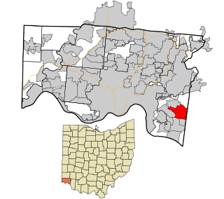
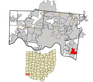
Dry Run is a census-designated place (CDP) in Hamilton County, Ohio, United States. The population was 7,672 at the 2020 census.

<span class="mw-page-title-main">Forestville, Ohio</span> Census-designated place in Ohio, United States

Forestville is a census-designated place (CDP) in Hamilton County, Ohio, United States. The population was 10,615 at the 2020 census.

<span class="mw-page-title-main">Sherwood, Hamilton County, Ohio</span> Census-designated place in Ohio, United States

Sherwood is a census-designated place (CDP) in Hamilton County, Ohio, United States. The population was 3,633 at the 2020 census.

<span class="mw-page-title-main">Turpin Hills, Ohio</span> Census-designated place in Ohio, United States

Turpin Hills is a census-designated place (CDP) in Anderson Township, Hamilton County, Ohio, United States. The population was 5,162 at the 2020 census.

Brent is a census-designated place (CDP) in Sequoyah County, Oklahoma, United States, south of Sallisaw. It is part of the Fort Smith, Arkansas-Oklahoma Metropolitan Statistical Area. The population was 504 at the 2000 census.

<span class="mw-page-title-main">Netarts, Oregon</span> Unincorporated community in the state of Oregon, United States

Netarts is an unincorporated community in Tillamook County, Oregon, United States; it is a census-designated place (CDP). The population was 744 at the 2000 census.

<span class="mw-page-title-main">Green Valley, South Dakota</span> CDP in South Dakota, United States

Green Valley is a census-designated place (CDP) and unincorporated community in Pennington County, South Dakota, United States. The population was 1,051 at the 2020 census.

<span class="mw-page-title-main">Max Meadows, Virginia</span> CDP in Virginia, United States

Max Meadows is a census-designated place (CDP) in Wythe County, Virginia, United States. The population was 562 at the 2010 census.

Vista West is a census-designated place (CDP) in Natrona County, Wyoming, United States. It is part of the Casper, Wyoming Metropolitan Statistical Area. The population was 951 at the 2010 census.

<span class="mw-page-title-main">Loveland Park, Ohio</span> Census-designated place in Ohio, United States

Loveland Park is a census-designated place (CDP) located in Symmes Township, Hamilton County and Deerfield Township, Warren County, in the southwestern part of the U.S. state of Ohio. The CDP is named after the city of Loveland. The population was 1,737 at the 2020 census.

<span class="mw-page-title-main">Scituate (CDP), Massachusetts</span> Census-designated place in Massachusetts, United States

Scituate is a census-designated place (CDP) in the town of Scituate in Plymouth County, Massachusetts, United States. The population was 5,245 at the 2010 census.

<span class="mw-page-title-main">Elwood, New Jersey</span> Populated place in Atlantic County, New Jersey, US

Elwood is an unincorporated community and census-designated place (CDP) located within Mullica Township in Atlantic County, in the U.S. state of New Jersey. As of the 2010 United States Census, the CDP's population was 1,437. At previous censuses, the area was listed by the U.S. Census Bureau as the Elwood-Magnolia CDP. The area is served as United States Postal Service ZIP Code 08217.

References

  1. "ArcGIS REST Services Directory". United States Census Bureau. Retrieved September 20, 2022.
  2. 1 2 U.S. Geological Survey Geographic Names Information System: Keener, North Carolina
  3. "Keener NC ZIP Code". zipdatamaps.com. 2023. Retrieved February 17, 2023.
  4. 1 2 "U.S. Census website". United States Census Bureau . Retrieved January 31, 2008.
  5. "Census of Population and Housing". Census.gov. Retrieved June 4, 2016.