Faison, North Carolina

Last updated

Faison, North Carolina
Faison, North Carolina.jpg
West Main Street in Faison
Faison, NC Town Flag.gif
Faison, NC Town Seal.png
USA North Carolina location map.svg
Red pog.svg
Faison
Location within the state of North Carolina
Coordinates: 35°06′59″N78°08′11″W / 35.11639°N 78.13639°W / 35.11639; -78.13639
Country United States
State North Carolina
Counties Duplin, Sampson
Area
[1]
  Total0.87 sq mi (2.24 km2)
  Land0.87 sq mi (2.24 km2)
  Water0.00 sq mi (0.00 km2)
Elevation
[2]
161 ft (49 m)
Population
 (2020)
  Total784
  Density905.31/sq mi (349.66/km2)
Time zone UTC-5 (Eastern (EST))
  Summer (DST) UTC-4 (EDT)
ZIP code
28341
Area codes 910, 472
FIPS code 37-22560 [3]
GNIS feature ID2406482 [2]
Website faisonnc.org

Faison is a town primarily in Duplin County, North Carolina, with a small portion extending into Sampson County. [4] The population was 784 at the 2020 U.S. census. [5]

Contents

History

Faison was originally called "Faison's Depot", and under the latter name was founded around 1833. [6] The town was named for Henry Faison, the original owner of the town site. [6] A post office has been in operation at Faison since 1838. [7]

The Faison Cemetery, Faison Historic District, Buckner Hill House, and John Wesley Mallard House are listed on the National Register of Historic Places. [8]

Geography

Faison is located in northwestern Duplin County. Two small parcels of land that are part of the town are located 3 miles (5 km) to the west of the rest of the town in Sampson County, next to Interstate 40. [9] U.S. Route 117 passes through the center of town, leading northeast 3 miles (5 km) to Calypso and 21 miles (34 km) to Goldsboro, and south 8 miles (13 km) to Warsaw. North Carolina Highway 403 leads west 3 miles (5 km) to Interstate 40 at Exit 355.

According to the United States Census Bureau, the town of Faison has a total area of 0.77 square miles (2.0 km2), all land. [5]

Demographics

Historical population
CensusPop.Note
1890 256
1900 30820.3%
1910 51968.5%
1920 477−8.1%
1930 58923.5%
1940 75127.5%
1950 7682.3%
1960 666−13.3%
1970 598−10.2%
1980 6366.4%
1990 70110.2%
2000 7446.1%
2010 96129.2%
2020 784−18.4%
U.S. Decennial Census [10]

2020 census

Faison racial composition [11]
RaceNumberPercentage
White (non-Hispanic)28336.1%
Black or African American (non-Hispanic)11514.67%
Native American 50.64%
Other/Mixed 364.59%
Hispanic or Latino 34544.01%

As of the 2020 United States census, there were 784 people, 401 households, and 273 families residing in the town.

2000 census

As of the census [3] of 2000, there were 736 people, 316 households, and 136 families residing in the town. The population density was 888.2 inhabitants per square mile (342.9/km2). There were 354 housing units at an average density of 422.6 per square mile (163.2/km2). The racial makeup of the town was 64.11% White, 14.78% African American, 0.13% Native American, 20.30% from other races, and 0.67% from two or more races. Hispanic or Latino of any race were 24.73% of the population.

There were 314 households, out of which 27.7% had children under the age of 18 living with them, 43.9% were married couples living together, 11.5% had a female householder with no husband present, and 37.3% were non-families. 33.4% of all households were made up of individuals, and 15.9% had someone living alone who was 65 years of age or older. The average household size was 2.36 and the average family size was 2.93.

In the town, the population was spread out, with 22.6% under the age of 18, 9.8% from 18 to 24, 30.5% from 25 to 44, 20.4% from 45 to 64, and 16.7% who were 65 years of age or older. The median age was 37 years. For every 100 females, there were 95.8 males. For every 100 females age 18 and over, there were 94.6 males.

The median income for a household in the town was $22,788, and the median income for a family was $30,724. Males had a median income of $25,536 versus $20,667 for females. The per capita income for the town was $12,558. About 18.7% of families and 27.5% of the population were below the poverty line, including 26.0% of those under age 18 and 24.3% of those age 65 or over.

Notable people

Related Research Articles

<span class="mw-page-title-main">Sampson County, North Carolina</span> County in North Carolina, United States

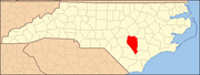
Sampson County is a county located in the U.S. state of North Carolina. As of the 2020 census, the population was 59,036. Its county seat is Clinton.

<span class="mw-page-title-main">Pender County, North Carolina</span> County in North Carolina, United States

Pender County is a county located in the U.S. state of North Carolina. As of the 2020 census, the population was 60,203. Its county seat is Burgaw. Pender County is part of the Wilmington, NC Metropolitan Statistical Area.

<span class="mw-page-title-main">Jones County, North Carolina</span> County in North Carolina, United States

Jones County is a county located in the U.S. state of North Carolina. As of the 2020 census, the population was 9,172, making it the fourth-least populous county in North Carolina. Its county seat is Trenton. Jones County is part of the New Bern, NC Micropolitan Statistical Area.

<span class="mw-page-title-main">Duplin County, North Carolina</span> County in North Carolina, United States

Duplin County is a county located in the U.S. state of North Carolina. As of the 2020 census, the population was 48,715. Its county seat is Kenansville.

<span class="mw-page-title-main">Icard, North Carolina</span> Census-designated place in North Carolina, United States

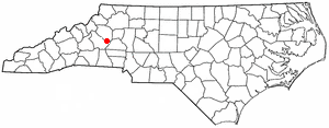
Icard is a census-designated place (CDP) in Burke County, North Carolina, United States. The population was 2,664 at the 2010 census. It is part of the Hickory–Lenoir–Morganton Metropolitan Statistical Area.

Beulaville is a town located in Duplin County, North Carolina, United States. The population was 1,296 as of 2010, making it the fourth most populous town in the county. The community lies within Limestone Creek Township.

<span class="mw-page-title-main">Calypso, North Carolina</span> Town in North Carolina, United States

Calypso is a town in Duplin County, North Carolina, United States. The population was 538 at the 2010 census.

Greenevers is a town in Duplin County, North Carolina, United States. The population was 634 at the 2010 census.

<span class="mw-page-title-main">Kenansville, North Carolina</span> Town in North Carolina, United States

Kenansville is a town in Duplin County, North Carolina, United States. Its population was 770 at the 2020 census. It is the county seat of Duplin County. The town was named for James Kenan, a member of the North Carolina Senate. Liberty Hall, his early 1800s era historic home, is located within Kenansville.

Magnolia is a town in Duplin County, North Carolina, United States. The population was 939 at the 2010 census.

<span class="mw-page-title-main">Rose Hill, North Carolina</span> Town in North Carolina, United States

Rose Hill is a town in Duplin County, North Carolina, United States. Its population was 1,371 at the 2020 census, down from 1,626 at the 2010 census. Rose Hill claims to be the home of the world's largest frying pan.

Teachey is a town in Duplin County, North Carolina, United States. Its population was 376 at the 2010 census.

<span class="mw-page-title-main">Warsaw, North Carolina</span> Town in North Carolina, United States

Warsaw is a town in Duplin County, North Carolina, United States. The population was 3,054 at the 2010 census.

<span class="mw-page-title-main">Clinton, North Carolina</span> City in North Carolina, United States

Clinton is a city in and the county seat of Sampson County, North Carolina, United States. As of the 2020 census, the population was 8,383. Clinton is named for Richard Clinton, a Brigadier General of the North Carolina militia in the American Revolution.

Newton Grove is a town in Sampson County, North Carolina, United States. It was chartered in 1879. The population was 585 at the 2020 U.S. census.

<span class="mw-page-title-main">Salemburg, North Carolina</span> Town in North Carolina, United States

Salemburg is a town in Sampson County, North Carolina, United States. The population was 435 at the 2010 census.

<span class="mw-page-title-main">Falcon, North Carolina</span> Town in North Carolina, United States

Falcon is a town in Cumberland and Sampson counties in the U.S. state of North Carolina. The population was 258 at the 2010 census.

Harrells is a town in Duplin and Sampson counties, North Carolina, United States. The population was 202 at the 2010 census.

<span class="mw-page-title-main">Wallace, North Carolina</span> Town in North Carolina, United States

Wallace is a town in Duplin and Pender counties in the U.S. state of North Carolina. The population was 3,883 at the 2020 census.

<span class="mw-page-title-main">Mount Olive, North Carolina</span> Town in North Carolina, United States

Mount Olive is a town in Duplin and Wayne counties in the U.S. state of North Carolina. The population was 4,589 at the 2010 census. It is included in the Goldsboro, North Carolina Metropolitan Statistical Area. The town is home to the Mt. Olive Pickle Company and the University of Mount Olive.

References

  1. "ArcGIS REST Services Directory". United States Census Bureau. Retrieved September 20, 2022.
  2. 1 2 U.S. Geological Survey Geographic Names Information System: Faison, North Carolina
  3. 1 2 "U.S. Census website". United States Census Bureau . Retrieved January 31, 2008.
  4. "Town of Faison, NC". Town of Faison, NC. Town of Faison, NC. Archived from the original on August 22, 2015. Retrieved August 23, 2015.
  5. 1 2 "Geographic Identifiers: 2010 Demographic Profile Data (G001): Faison town, North Carolina". U.S. Census Bureau, American Factfinder. Archived from the original on February 13, 2020. Retrieved November 30, 2015.
  6. 1 2 Proffitt, Martie (April 17, 1983). "Local history offers tasty tidbits". Star-News. pp. 8C. Retrieved November 1, 2015.
  7. "Duplin County". Jim Forte Postal History. Archived from the original on February 2, 2016. Retrieved November 1, 2015.
  8. "National Register Information System". National Register of Historic Places . National Park Service. July 9, 2010.
  9. "TIGERweb". U.S. Census Bureau Geography Division. Retrieved November 30, 2015.
  10. "Census of Population and Housing". Census.gov. Retrieved June 4, 2015.
  11. "Explore Census Data". data.census.gov. Retrieved December 24, 2021.