North Carolina Highway 403

Last updated

NC 403.svg
North Carolina Highway 403
NC 403 highlighted in red
Route information
Maintained by NCDOT
Length25.7 mi [1]  (41.4 km)
Existed1933 [2] –present
Major junctions
South endBusiness plate.svg
US 701.svg
US 701 Bus. in Clinton
Major intersections
North endNC 55.svg NC 55 in Williams
Location
Country United States
State North Carolina
Counties Sampson, Duplin, Wayne
Highway system
US 401.svg US 401 NC 410.svg NC 410

North Carolina Highway 403 (NC 403) is a primary state highway located in U.S. State of North Carolina. The highway travels through Sampson, Duplin, and Wayne Counties between its southern terminus at U.S. Route 701 Business (US 701 Business) in Clinton and NC 55 in Williams. Between its termini, NC 403 connects to Interstate 40 (I-40) and Faison. The highway is primarily rural and predominantly travels through rural forests and farmlands. While signed in a north-south direction, NC 403 physically travels in a northeast-southwest direction along the duration of its route.

Contents

Prior to the establishment of NC 403, multiple secondary roads linked Clinton and Faison. NC 403 was established in 1933, running along secondary roads from US 701/NC 23 north of Clinton to US 117/NC 40 in Faison. By 1935, the southern terminus was shifted to NC 24 at Warsaw Road in Clinton. NC 403 was extended northeast from Faison to NC 55 in Williams in 1957. The southern terminus of NC 403 was once again moved from Warsaw Road to US 701 (modern-day US 701 Business) in 1966. In 2009, US 117 Connector was routed from I-40 to US 117, creating a 0.2-mile (0.32 km) concurrency near the I-40 interchange.

Route description

NC 403 is a predominantly two-lane rural highway that traverses 25.7 miles (41.4 km) from Clinton to Williams. The southern terminus of NC 403 is located at an at-grade intersection with US 701 Business (Northeast Boulevard) northeast of downtown Clinton. From the intersection, NC 403 runs northeastward along the two-lane Faison Highway, exiting Clinton to the northeast. Outside of Clinton, the majority of the surrounding area is farmland and forested areas. However, some residential neighborhoods are located adjacent to NC 403 on the outskirts of the city. The highway crosses Beaverdam Swamp and makes a gradual turn northward. Beyond the initial curve, the highway makes several minor turns to return to a northeastern orientation. NC 403 intersects Keener Road which runs westward to the census-designated place of Keener. The highway crosses several other river branches of the Cape Fear River as it approaches I-40. As NC 403 approaches I-40, it widens to a four-lane divided highway. NC 403 meets I-40 at a diamond interchange (I-40 exit 355) southwest of Faison. US 117 Connector begins at the interchange, marking the beginning of the NC 403/US 117 Connector concurrency. NC 403 continues northeast for 0.2 miles (0.32 km) until reaching an at-grade intersection northeast of I-40. At the intersection, NC 403 turns southeastward toward Faison while US 117 Connector continues northeast toward Calypso. [1] [3]

NC 403 and NC 50 travel concurrently through the Faison Historic District in Faison. Main east of Faison.jpg
NC 403 and NC 50 travel concurrently through the Faison Historic District in Faison.

NC 403 travels 0.7 miles (1.1 km) before crossing into Duplin County. Approaching Faison, NC 403 makes a reverse curve before intersecting NC 50 west of the town. At the intersection, NC 50 turns to run concurrently with NC 403 to the east. Entering Faison from the west, NC 403 and NC 50 travel along Main Street to pass through the downtown area of Faison. Immediately east of the central business area, the highway crosses a CSX Transportation owned railroad line at an at-grade crossing [4] and meets US 117/NC 50 at an intersection. The NC 403/NC 50 concurrency ends at the intersection as NC 50 turns south to follow US 117 toward Warsaw. NC 403 exits Faison to the east and the surrounding area becomes predominately farmland. The highway makes a turn to the northeast and intersects several secondary roads that run northwest to Calypso. NC 403 makes a turn to the southeast before intersecting Beautancus Road which runs north to Mount Olive. At the intersection, the highway turns back to the northeast, an orientation it largely remains for the duration of its route. NC 403 passes through a community southeast of Mount Olive, with several businesses and residential buildings located adjacent to the highway. From the community, NC 403 continues northeastward for 2.1 miles (3.4 km) and crosses the Northeast Cape Fear River and enters Wayne County. It continues 0.7 miles (1.1 km) to its northern terminus at NC 55 in the unincorporated community of Williams. [1] [3]

The North Carolina Department of Transportation (NCDOT) measures average daily traffic volumes along many of the roadways it maintains. In 2016, average daily traffic volumes along NC 403 varied from 1,200 vehicles per day at the Northeast Cape Fear River to 12,000 vehicles per day along the section to roadway concurrent with US 117 Connector east of I-40. [5] [6] [7] NC 403 is part of the National Highway System for 0.2 miles (0.32 km), entirely concurrent with US 117 Connector near Faison. Additionally, NC 403 connects with the National Highway system at I-40. [8]

History

In 1930, several graded secondary roads linked Clinton and Faison along the future routing of NC 403. [9] [10] NC 403 first appeared on North Carolina state highway maps in 1933. The highway began at US 701/NC 23 two miles (three point two kilometres) north of Clinton and ran northeast to US 117/NC 40 in Faison. From its establishment NC 403 was classified as a gravel or topsoil road. [11] [2] By 1935, the southern terminus of NC 403 was adjusted to the south ending at NC 24 (modern-day Warsaw Road) in Clinton. [12] [13] The highway was paved by 1940. [14] In 1957, the northern terminus of NC 403 was extended northeast from US 117 in Faison to NC 55 in Williams. [15] [16] The majority of the new NC 403 routing was along pre-existing secondary roads between Faison and Williams. However, a new highway was created between modern-day Bill Clifton Road and Friendship Church Road, east of Faison. [17] [18] In 1966, NC 403 was shortened by 0.4 miles (0.64 km) on its southern end. The southern terminus was moved from Warsaw Road to US 701 (modern-day US 701 Business), removing NC 403 from College Street. [19] The routing of NC 403 near I-40 was adjusted upon the construction of a secondary road (Sampson County SR 1723) running from NC 403 to US 117. Completed by 1995, a curve along NC 403 east of I-40 was eliminated in favor of the modern-day intersection. [20] [21] [22] In 2009, US 117 Connector was established from I-40 to US 117 near Calypso. The new connector route replaced Sampson County SR 1723 and was routed to overlap NC 403 for 0.2 miles (0.32 km) northeast of I-40. [23]

Major intersections

CountyLocationmi [1] kmDestinationsNotes
Sampson Clinton 0.00.0Business plate.svg
US 701.svg
US 701 Bus.  Newton Grove, Elizabethtown
Southern terminus
11.218.0I-40.svgConnector plate.svg
US 117.svg
I-40  / US 117 Conn.  Wilmington, Newton Grove
South end of US 117 Conn. overlap; exit 355 (I-40); diamond interchange
11.518.5Connector plate.svg
US 117.svg
US 117 Conn. north Mount Olive, Goldsboro
North end of US 117 Conn. overlap
Duplin Faison 13.621.9NC 50.svg NC 50 north Newton Grove North end of NC 50 overlap
14.323.0US 117.svgNC 50.svg US 117  / NC 50 south Goldsboro, Wilmington South end of NC 50 overlap
Wayne Williams 25.741.4NC 55.svg NC 55  Kinston, Mount Olive Northern terminus
1.000 mi = 1.609 km; 1.000 km = 0.621 mi

Related Research Articles

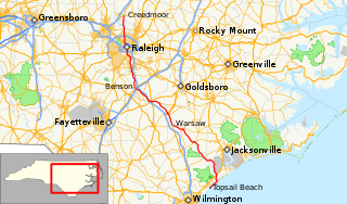
U.S. Route 701 is an auxiliary route of US 1 in the U.S. states of South Carolina and North Carolina. The U.S. Highway runs 171.45 miles (275.92 km) from US 17 and US 17 Alternate in Georgetown, South Carolina north to US 301, North Carolina Highway 96, and Interstate 95 (I-95) near Four Oaks, North Carolina. US 701 serves the Pee Dee region of South Carolina and the southern and central portions of Eastern North Carolina. The highway connects Georgetown and Conway in South Carolina with the North Carolina cities of Whiteville, Elizabethtown, Clinton, and a short distance north of its terminus, Smithfield. US 701 has four business routes in North Carolina, including those through Tabor City, Whiteville, Clarkton, and Clinton.

U.S. Route 117 (US 117) is a north-south United States Highway located completely within the state of North Carolina. A spur route of US 17, the highway runs for 114 miles (183 km) from the Port of Wilmington, south of downtown Wilmington, to US 301 near Wilson. From its southern terminus, US 117 runs along Shipyard Boulevard and College Road, concurrent with North Carolina Highway 132 (NC 132) through Wilmington. US 117 intersects the eastern terminus of Interstate 40 (I-40) and parallels the interstate until reaching Faison, passing through Burgaw, Wallace, and Warsaw. The highway diverges from I-40 in Faison, running north-northeast through Mount Olive, Goldsboro, and Pikeville to its northern terminus. US 117 meets the southern end of I-795 in Goldsboro, and parallels that route before reaching its northern terminus at US 301 south of Wilson.

North Carolina Highway 132 (NC 132) is a north-south North Carolina State Highway entirely in New Hanover County. The highway follows College Road for the duration of its route. The southern terminus of NC 132 begins at U.S. Route 421 (US 421) in the census-designated place of Myrtle Grove south of Wilmington. Continuing north, NC 132 continues along a major north-south artillery road in the city of Wilmington. Between Shipyard Boulevard and its northern terminus, NC 132 runs concurrently with US 117. NC 132 shares a short concurrency at the eastern terminus of Interstate 40 (I-40), before continuing north toward Castle Hayne. The northern terminus of NC 132 is located at a roundabout with US 117 and NC 133 just south of the main business district of Castle Hayne.

North Carolina Highway 2 State highway in Moore County, North Carolina, US

North Carolina Highway 2 (NC 2) is a primary state highway in the U.S. state of North Carolina. The highway runs between the towns of Pinehurst and Southern Pines connecting NC 5 with US 1. Much of the routing is known as Midland Road, a four lane road connecting the two towns.

North Carolina Highway 67 (NC 67) is a 40.9-mile-long (65.8 km) primary state highway in the U.S. state of North Carolina. NC 67 travels through Yadkin County and Forsyth County between its western terminus at U.S. Route 21 Business in Jonesville and NC 150 in Winston-Salem. The highway primarily follows an east–west alignment and connects the towns of Jonesville, Boonville, and East Bend, along with the city of Winston-Salem.

North Carolina Highway 50 State highway in North Carolina, US

North Carolina Highway 50 (NC 50) is a primary state highway in the U.S. state of North Carolina. It traverses north–south, from Topsail Beach to Creedmoor, connecting the cities of Warsaw, Newton Grove, Benson, and Raleigh.

North Carolina Highway 11 State highway in North Carolina, US

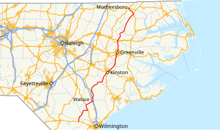
North Carolina Highway 11 (NC 11) is a primary state highway in the U.S. state of North Carolina. Traveling 193.2 miles (310.9 km) in a north–south alignment through Eastern North Carolina, it connects the towns and cities of Wallace, Kenansville, Kinston, Greenville and Murfreesboro.

North Carolina Highway 54 State highway in North Carolina, US

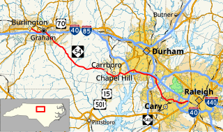
North Carolina Highway 54 (NC 54) is a 55.0-mile-long (88.5 km) primary state highway in the U.S. state of North Carolina. The highway serves the Research Triangle area, between Burlington and Raleigh, connecting the cities and towns of Chapel Hill, Durham, Morrisville and Cary. The highway also links the campuses of University of North Carolina at Chapel Hill and North Carolina State University.

Interstate 40 (I-40) is a part of the Interstate Highway System that runs from Barstow, California, to Wilmington, North Carolina. In North Carolina, I-40 enters the state along the Pigeon River Gorge, from Tennessee. Crossing the entire state, it connects the cities of Asheville, Statesville, Winston-Salem, Greensboro, Burlington, Durham, and Raleigh before ending along U.S. Highway 117 (US 117)/NC 132 in Wilmington. The landscapes traversed by I-40 include the Blue Ridge Mountains, the foothills of western North Carolina, suburban communities, and the urban core of several Piedmont cities, along with eastern North Carolina farmland. At a total of 420.21 miles (676.26 km), it is the longest Interstate Highway in North Carolina. There are five auxiliary Interstates in the state related to I-40, as well as one business loop which formerly ran through Winston-Salem. The route is labeled east–west for the entire route ; however, the eastern portion follows a much more north–south alignment.

North Carolina Highway 99 (NC 99) is a primary state highway in the U.S. state of North Carolina in the central Coastal Plain region of the state. It runs from NC 92/NC 306 east of Bath to NC 32/NC 45 south of Plymouth. The highway serves the towns of Belhaven and Patego. NC 99 also serves as a partial link between Bath, Belhaven and Plymouth. The highway primarily runs through rural regions of Beaufort County, Hyde County, and Washington County.

North Carolina Highway 111 State highway in North Carolina, US

North Carolina Highway 111 (NC 111) is a 126.0-mile-long (202.8 km) primary state highway in the U.S. state of North Carolina. Traveling north–south through Eastern North Carolina, it connects the various rural towns and communities with the cities of Jacksonville, Goldsboro and Tarboro.

Interstate 795 (I-795) is an auxiliary Interstate Highway spur in the U.S. state of North Carolina. It runs 24 miles (39 km), connecting the city of Goldsboro to I-95 just south of Wilson, paralleling the northern portion of U.S. Route 117 (US 117). The road runs a short 5-mile (8.0 km) concurrency with US 264 in the last section of the route. It serves as a primary freeway spur for the city of Goldsboro to the Interstate Highway system, as well part of a major cargo route for the cities of Down East North Carolina, which was a part of the impetus for its designation in 2007.

North Carolina Highway 157 (NC 157) is a 29.3-mile-long (47.2 km) primary state highway in the U.S. state of North Carolina. The highway runs in a north–south direction from Interstate 85 (I-85), U.S. Route 15 (US 15), US 70, and US 501 in Durham, to US 158, US 501, and NC 57 in Roxboro. The highway serves the cities of Durham and Roxboro, along with the communities of Caldwell and Hurdle Mills. NC 157 is named Guess Road between its southern terminus and Hurdle Mills, and Hurdle Mills Road between Hurdle Mills and the Roxboro city limits. NC 157 does not directly parallel US 501, however, the two highways generally follow a similar alignment between Durham and Roxboro. NC 157 serves the counties of Durham, Orange, and Person.

U.S. Highway 76 (US 76) is a U.S. Highway running from Chattanooga, Tennessee to Wrightsville Beach, North Carolina. In North Carolina the highway runs for 80.4 miles (129.4 km) in the southeastern region of the state. US 76 enters the state from South Carolina south of Fair Bluff in Columbus County. Travelling in an eastward direction, US 76 meets US 74 in Chadbourn. The two highways run concurrently for 50.4 miles (81.1 km) between Chadbourn and Wilmington. US 76 runs concurrently with US 17 along much of its Wilmington routing, until once again meeting US 74. US 76 and US 74 run concurrently for 1.4 miles (2.3 km) until reaching Wrightsville Beach. US 76 reaches its eastern terminus on the south side of Wrightsville Beach, at an intersection with Water Street.

North Carolina Highway 210 is a 192-mile-long (309 km) primary state highway in the U.S. state of North Carolina that connects settlements in the Atlantic Coastal Plain region. Due to its meandering route NC 210 changes directional orientation twice, changing from east-west to north-south at Old Stage Road east of Angier, then changing from north-south to west-east at the Bladen–Pender county line. The route traverses through central Fayetteville and the Fort Bragg Army installation and crosses both Topsail Island access bridges over the Atlantic Intracoastal Waterway. Owing primarily to its meandering route, NC 210 is the sixth longest state highway in North Carolina.

North Carolina Highway 79 (NC 79) is an 8.7-mile-long (14.0 km) primary state highway in the U.S. state of North Carolina. NC 79 runs from the South Carolina border as a continuation of South Carolina Highway 79 at Gibson to U.S. Route 15 (US 15), US 401, US 501, and US 74 Business in Laurinburg. While signed north–south, NC 79 physically travels in an east–west direction between its termini. NC 79 is primarily a two-lane road running through rural Scotland County and residential areas west of Laurinburg. Combined with SC 79, the highways form a coherent route between SC 9 northwest of Bennettsville, South Carolina and Laurinburg.

North Carolina Highway 231 (NC 231) is a 25.4-mile-long (40.9 km) primary state highway in the U.S. state of North Carolina. NC 231 travels through Wake County, Johnston County, and Nash County between its southern terminus at U.S. Route 64 Business in Wendell and its northern terminus at US 64 Alternate/NC 98 near Spring Hope. Throughout Wake County and Johnston County, NC 231 primarily follows a southeast-northwest alignment. Entering into Nash County, NC 231 turns to follow a northerly alignment until reaching its northern terminus. NC 231 serves the towns of Wendell, Middlesex, and Spring Hope.

North Carolina Highway 133 (NC 133) is a primary state highway in the U.S. state of North Carolina. It traverses 46.6 miles (75.0 km) from Oak Island Drive in Oak Island to NC 210 in Bells Crossroads. The route serves communities such as Southport, Belville, Leland, Wilmington, and Castle Hayne. Additionally, NC 133 serves as an entry point for Military Ocean Terminal Sunny Point located to its east. Much of NC 133 runs parallel to the Cape Fear River and Brunswick River between Southport and Belville. West of Wilmington, NC 133 runs concurrently with U.S. Route 17 (US 17), US 74, and US 76. The road follows another concurrency along US 74 and US 421, west of Downtown Wilmington, and crosses into New Hanover County on the Isabel Holmes Bridge. North of Wilmington, NC 133 exits to the north, serving several suburban communities north of Wilmington. NC 133 runs concurrently with US 117 through Castle Hayne, before bearing northwest toward Bells Crossroads.

North Carolina Highway 241 (NC 241) is a primary state highway in the U.S. state of North Carolina. NC 241 travels for 9.1 miles (14.6 km) from NC 41/NC 111 in Beulaville to NC 11 in Pink Hill. Outside of Beulaville and Pink Hill, NC 241 is a rather straight, predominantly rural route. The highway travels through Duplin County for 7.6 miles (12.2 km) while traveling 1.5 miles (2.4 km) in Lenoir County.

Several special routes of U.S. Route 701 exist, from South Carolina to North Carolina. In order from south to north, separated by type, they are as follows.

References

  1. 1 2 3 4 Google (February 27, 2014). "North Carolina Highway 403" (Map). Google Maps . Google. Retrieved February 27, 2014.
  2. 1 2 North Carolina State Highway Commission (1933). State Highway System of North Carolina (Map) (1933 ed.). 1:887,040. Cartography by C.M. Sawyer. Raleigh: North Carolina State Highway Commission.
  3. 1 2 North Carolina Department of Transportation; North Carolina State Tax Commission (2019). State Transportation Map (Map) (2019–2020 ed.). Raleigh: North Carolina Department of Transportation.
  4. North Carolina Department of Transportation (2017). North Carolina Rail Operators and Branches (PDF) (Map). Raleigh: North Carolina Department of Transportation.
  5. North Carolina Department of Transportation Management Systems and Assessments Unit (2016). Sampson County, North Carolina (PDF) (Map) (2016 ed.). Raleigh: North Carolina Department of Transportation.
  6. North Carolina Department of Transportation Management Systems and Assessments Unit (2016). Duplin County, North Carolina (PDF) (Map) (2016 ed.). Raleigh: North Carolina Department of Transportation.
  7. North Carolina Department of Transportation Management Systems and Assessments Unit (2016). Wayne County, North Carolina (PDF) (Map) (2016 ed.). Raleigh: North Carolina Department of Transportation.
  8. Federal Highway Administration Management Systems and Assessments Unit (September 20, 2020). National Highway System: North Carolina (PDF) (Map). Washington, DC: Federal Highway Administration.
  9. North Carolina State Highway Commission (1930). Sampson County (PDF) (Map). Raleigh: North Carolina State Highway Commission.
  10. North Carolina State Highway Commission (1930). Duplin County (PDF) (Map). Raleigh: North Carolina State Highway Commission.
  11. North Carolina State Highway Commission (1932). State Highway System of North Carolina (Map) (1932 ed.). Raleigh: North Carolina State Highway Commission.
  12. Sawyer, C.M. (1935). State highway system of North Carolina (Map). Raleigh: North Carolina State Highway Commission.
  13. North Carolina State Highway Commission (1936). Sampson County (PDF) (Map). Raleigh: North Carolina State Highway Commission.
  14. North Carolina State Highway and Public Works Commission (1940). North Carolina Primary Highway System (Map) (1940 ed.). 1:823,680. Raleigh: North Carolina State Highway and Public Works Commission.
  15. Sawyer, C.M. (1956). North Carolina (Map). Winston-Salem: North Carolina State Highway and Public Works Commission.
  16. Sawyer, C.M. (1957). North Carolina Official Highway Map (Map). Winston-Salem: Winston Printing Company.
  17. North Carolina State Highway and Public Works Commission (1953). Duplin County (PDF) (Map). Raleigh: North Carolina State Highway and Public Works Commission.
  18. North Carolina State Highway and Public Works Commission (1957). Duplin County (PDF) (Map). Raleigh: North Carolina State Highway and Public Works Commission.
  19. "NC Route Changes (1966-01-07)" (PDF). Raleigh: North Carolina Department of Transportation. January 7, 1966. p. 2. Retrieved February 27, 2014.
  20. North Carolina Official Transportation Map (Map). 1:823,680. Raleigh: North Carolina Department of Transportation. 1993.
  21. North Carolina Official Transportation Map (Map). 1:823,680. Raleigh: North Carolina Department of Transportation. 1995.
  22. North Carolina Department of Transportation (1999–2000). Duplin County (PDF) (Map). Raleigh: North Carolina Department of Transportation.
  23. "US 117 Connector (2009-03-09)" (PDF). Raleigh: North Carolina Department of Transportation. March 9, 2009. p. 2. Retrieved December 31, 2020.
KML file (edithelp)
    KML is from Wikidata