
Pender County is a county located in the U.S. state of North Carolina. As of the 2020 census, the population was 60,203. Its county seat is Burgaw. Pender County is part of the Wilmington, NC Metropolitan Statistical Area.

Duplin County is a county located in the U.S. state of North Carolina. As of the 2020 census, the population was 48,715. Its county seat is Kenansville.

Clarkton is a town in Bladen County, North Carolina, United States. The population was 614 at the 2020 census.
Beulaville is a town located in Duplin County, North Carolina, United States. As of the 2020 census, the population was 1,116. The community lies within the Limestone Creek Township.

Calypso is a town in Duplin County, North Carolina, United States. At the 2020 census, the population was 327.
Greenevers is a town in Duplin County, North Carolina, United States. As of the 2020 census, the population was 567.

Kenansville is a town in Duplin County, North Carolina, United States. Its population was 770 at the 2020 census. It is the county seat of Duplin County. The town was named for James Kenan, a member of the North Carolina Senate. Liberty Hall, his early 1800s era historic home, is located within Kenansville.
Magnolia is a town in Duplin County, North Carolina, United States. At the 2020 census, the population was 831.

Rose Hill is a town in Duplin County, North Carolina, United States. At the 2020 census, the population was 1,371. Rose Hill claims to be the home of the world's largest frying pan.
Teachey is a town in Duplin County, North Carolina, United States. At the 2020 census, the population was 448.
Walkertown is a town in Forsyth County, North Carolina, United States and a rural area outside of Winston-Salem. It is part of the Piedmont Triad. The population was 5,695 at the 2020 census.
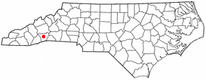
Balfour is an unincorporated community and census-designated place (CDP) in Henderson County, North Carolina, United States. The population was 1,187 at the 2010 census. It is part of the Asheville Metropolitan Statistical Area.

Somerville is a town in Fayette County, Tennessee, United States. It is part of the Memphis metropolitan area. The population was 3,415 at the 2020 census, up from 3,094 at the 2010 census. It is the county seat of Fayette County.

Ridgeway is a town in Henry County, Virginia, United States. The population was 742 at the 2010 census. It is part of the Martinsville Micropolitan Statistical Area. Martinsville Speedway, a NASCAR racetrack, is located between Ridgeway and the Martinsville city limits.
Maiden is a town in Catawba and Lincoln counties in the U.S. state of North Carolina. The population was 3,310 at the 2010 census.
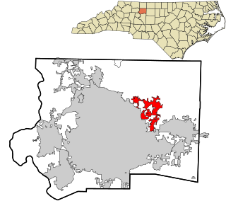
Kings Mountain is a small suburban city within the Charlotte metropolitan area in Cleveland and Gaston counties, North Carolina, United States. Most of the city is in Cleveland County, with a small eastern portion in Gaston County. The population was 10,296 at the 2010 census.

Faison is a town in Duplin and Sampson counties, North Carolina, United States. At the 2020 census, the population was 784.
Harrells is a town in Duplin and Sampson counties, North Carolina, United States. The population was 160 at the 2020 census. At the previous census in 2010, the population was 202.

Wallace is a town in Duplin and Pender counties in the U.S. state of North Carolina. The population was 3,883 at the 2020 census. The Pender County portion of Wallace is part of the Wilmington Metropolitan Statistical Area. The town of Wallace was first known as Duplin Crossroads and was incorporated into existence in 1873. Later in 1899, the town fathers decided to adopt the new name, Wallace, to honor Stephen D. Wallace, an official of the Atlantic Coast Line Railroad. Wallace is Duplin County's largest population and retail trade center serving over 50,000 people in a surrounding three county area.

Mount Olive is a town in Duplin and Wayne counties in the U.S. state of North Carolina. At the 2020 census, the population was 4,198. It is included in the Goldsboro, North Carolina Metropolitan Statistical Area. The town is home to the Mt. Olive Pickle Company and the University of Mount Olive.


