Rose Hill, North Carolina

Last updated

Rose Hill, North Carolina
Rose Hill, North Carolina.jpg
USA North Carolina location map.svg
Red pog.svg
Rose Hill
Location within the state of North Carolina
Coordinates: 34°49′34″N78°01′33″W / 34.82611°N 78.02583°W / 34.82611; -78.02583
Country United States
State North Carolina
County Duplin
Area
[1]
  Total1.45 sq mi (3.74 km2)
  Land1.45 sq mi (3.74 km2)
  Water0.00 sq mi (0.00 km2)
Elevation
[2]
98 ft (30 m)
Population
 (2020)
  Total1,371
  Density948.79/sq mi (366.36/km2)
Time zone UTC-5 (Eastern (EST))
  Summer (DST) UTC-4 (EDT)
ZIP code
28458
Area codes 910, 472
FIPS code 37-57860 [3]
GNIS feature ID2407244 [2]
Website townofrosehillnc.com

Rose Hill is a town in Duplin County, North Carolina, United States. Its population was 1,371 at the 2020 census, down from 1,626 at the 2010 census. [4] Rose Hill claims to be the home of the world's largest frying pan. [5]

Contents

History

A post office called Rose Hill was established in 1872. [6] The town was named for the abundance of wild roses near the original town site. [7]

Geography

Rose Hill is located in southwestern Duplin County. U.S. Route 117 passes through the center of town, leading north 12 miles (19 km) to Warsaw and south 7 miles (11 km) to Wallace. Interstate 40 passes just east of the town, with access from exit 380. It leads south 49 miles (79 km) to Wilmington and north 84 miles (135 km) to Raleigh.

According to the United States Census Bureau, Rose Hill has a total area of 1.4 square miles (3.7 km2), all land. [4]

Demographics

Historical population
CensusPop.Note
1910 364
1920 51641.8%
1930 5547.4%
1940 72731.2%
1950 89623.2%
1960 1,29244.2%
1970 1,44812.1%
1980 1,5084.1%
1990 1,287−14.7%
2000 1,3303.3%
2010 1,62622.3%
2020 1,371−15.7%
U.S. Decennial Census [8]

2020 census

Rose Hill racial composition [9]
RaceNumberPercentage
White (non-Hispanic)55340.34%
Black or African American (non-Hispanic)36526.62%
Native American 80.58%
Asian 50.36%
Other/Mixed 332.41%
Hispanic or Latino 40729.69%

As of the 2020 United States census, there were 1,371 people, 823 households, and 554 families residing in the town.

2000 census

As of the census [3] of 2000, 1,330 people, 542 households, and 377 families resided in the town. The population density was 969.4 inhabitants per square mile (374.3/km2). The 594 housing units averaged 433.0 per square mile (167.4/km2). The racial makeup of the town was 62.93% White, 25.26% African American, 0.75% Native American, 0.53% Asian, 0.08% Pacific Islander, 9.92% from other races, and 0.53% from two or more races. Hispanics or Latinos of any race were 14.74% of the population.

Of the 542 households, 26.8% had children under the age of 18 living with them, 51.1% were married couples living together, 14.6% had a female householder with no husband present, and 30.3% were not families. About 27.7% of all households were made up of individuals, and 15.3% had someone living alone who was 65 years of age or older. The average household size was 2.45 and the average family size was 2.92.

In the town, the population was distributed as 21.3% under the age of 18, 9.5% from 18 to 24, 27.3% from 25 to 44, 24.4% from 45 to 64, and 17.6% who were 65 years of age or older. The median age was 39 years. For every 100 females, there were 86.0 males. For every 100 females age 18 and over, there were 82.4 males.

The median income for a household in the town was $27,794, and for a family was $36,786. Males had a median income of $27,171 versus $17,411 for females. The per capita income for the town was $16,943. About 15.7% of families and 19.9% of the population were below the poverty line, including 21.2% of those under age 18 and 16.9% of those age 65 or over.

Notable people

Related Research Articles

<span class="mw-page-title-main">Jones County, North Carolina</span> County in North Carolina, United States

Jones County is a county located in the U.S. state of North Carolina. As of the 2020 census, the population was 9,172, making it the fourth-least populous county in North Carolina. Its county seat is Trenton. Jones County is part of the New Bern, NC Micropolitan Statistical Area.

<span class="mw-page-title-main">Duplin County, North Carolina</span> County in North Carolina, United States

Duplin County is a county located in the U.S. state of North Carolina. As of the 2020 census, the population was 48,715. Its county seat is Kenansville.

<span class="mw-page-title-main">Shallotte, North Carolina</span> Town in North Carolina, United States

Shallotte is a town in Brunswick County, North Carolina, United States. The population was 3,675 at the 2010 census. The Shallotte River passes through the town.

<span class="mw-page-title-main">Rutherford College, North Carolina</span> Town in North Carolina, United States

Rutherford College is a town in Burke County, North Carolina, United States. As of the 2010 census, the town population was 1,341. It is part of the Hickory–Lenoir–Morganton Metropolitan Statistical Area.

Beulaville is a town located in Duplin County, North Carolina, United States. As of the 2020 census, the population was 1,116. At the previous census in 2010, the population was 1,296. The community lies within the Limestone Creek Township.

<span class="mw-page-title-main">Calypso, North Carolina</span> Town in North Carolina, United States

Calypso is a town in Duplin County, North Carolina, United States. As of the 2020 census, the population was 327. At the previous census in 2010, the population was 538.

Greenevers is a town in Duplin County, North Carolina, United States. As of the 2020 census, the population was 567. At the previous census in 2010, the population was 634.

<span class="mw-page-title-main">Kenansville, North Carolina</span> Town in North Carolina, United States

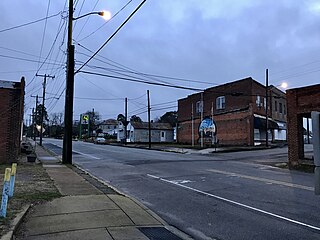
Kenansville is a town in Duplin County, North Carolina, United States. Its population was 770 at the 2020 census. It is the county seat of Duplin County. The town was named for James Kenan, a member of the North Carolina Senate. Liberty Hall, his early 1800s era historic home, is located within Kenansville.

Magnolia is a town in Duplin County, North Carolina, United States. As of the 2020 census, the population was 831. At the previous census in 2010, the population was 939.

Teachey is a town in Duplin County, North Carolina, United States. Its population was 376 at the 2010 census.

<span class="mw-page-title-main">Warsaw, North Carolina</span> Town in North Carolina, United States

Warsaw is a town in Duplin County, North Carolina, United States. The population was 3,054 at the 2010 census.

<span class="mw-page-title-main">Walkertown, North Carolina</span> Town in North Carolina, United States

Walkertown is a town in Forsyth County, North Carolina, United States and a rural area outside of Winston-Salem. It is part of the Piedmont Triad. The population was 5,695 at the 2020 census.

<span class="mw-page-title-main">Bunn, North Carolina</span> Town in North Carolina, United States

Bunn is a town in Franklin County, North Carolina, United States. The population was 327 at the 2020 census.

<span class="mw-page-title-main">Nashville, North Carolina</span> Town in North Carolina, United States

Nashville is a town in Nash County, North Carolina, United States. The town was founded in 1780 and features Victorian and Queen Anne style homes. It is part of the Rocky Mount, North Carolina Metropolitan Statistical Area. The population of Nashville was 5,632 in 2020. It is the county seat of Nash County.

<span class="mw-page-title-main">Carolina Beach, North Carolina</span> Town in North Carolina, United States

Carolina Beach is a beach town in New Hanover County, North Carolina, United States, situated about 12 miles (19 km) south of Wilmington International Airport in southeastern coastal North Carolina. As of the 2020 census, the city population was 6,564. It is part of the Wilmington metropolitan area. The community of Wilmington Beach was annexed by the town in 2000.

<span class="mw-page-title-main">Nokomis, Wisconsin</span> Town in Wisconsin, United States

Nokomis is a town in Oneida County, Wisconsin, United States. The population was 1,371 at the 2010 census.

<span class="mw-page-title-main">Faison, North Carolina</span> Town in North Carolina, United States

Faison is a town primarily in Duplin County, North Carolina, with a small portion extending into Sampson County. As of the 2020 census, the population was 784. At the previous census in 2010, the population was 961.

Harrells is a town in Duplin and Sampson counties, North Carolina, United States. The population was 160 at the 2020 census. At the previous census in 2010, the population was 202.

<span class="mw-page-title-main">Wallace, North Carolina</span> Town in North Carolina, United States

Wallace is a town in Duplin and Pender counties in the U.S. state of North Carolina. The population was 3,883 at the 2020 census. The Pender County portion of Wallace is part of the Wilmington Metropolitan Statistical Area. The town of Wallace was first known as Duplin Crossroads and was incorporated into existence in 1873. Later in 1899, the town fathers decided to adopt the new name, Wallace, to honor Stephen D. Wallace, an official of the Atlantic Coast Line Railroad. Wallace is Duplin County's largest population and retail trade center serving over 50,000 people in a surrounding three county area.

<span class="mw-page-title-main">Mount Olive, North Carolina</span> Town in North Carolina, United States

Mount Olive is a town in Duplin and Wayne counties in the U.S. state of North Carolina. The population was 4,589 at the 2010 census. It is included in the Goldsboro, North Carolina Metropolitan Statistical Area. The town is home to the Mt. Olive Pickle Company and the University of Mount Olive.

References

  1. "ArcGIS REST Services Directory". United States Census Bureau. Retrieved September 20, 2022.
  2. 1 2 U.S. Geological Survey Geographic Names Information System: Rose Hill, North Carolina
  3. 1 2 "U.S. Census website". United States Census Bureau . Retrieved January 31, 2008.
  4. 1 2 "Geographic Identifiers: 2010 Demographic Profile Data (G001): Rose Hill town, North Carolina". U.S. Census Bureau, American Factfinder. Archived from the original on February 13, 2020. Retrieved December 1, 2015.
  5. "Rose Hill, North Carolina: World's Largest Frying Pan". Roadside America. Retrieved December 16, 2007.
  6. "Duplin County". Jim Forte Postal History. Retrieved November 1, 2015.
  7. Proffitt, Martie (April 17, 1983). "Local history offers tasty tidbits". Star-News. pp. 8C. Retrieved November 1, 2015.
  8. "Census of Population and Housing". Census.gov. Retrieved June 4, 2015.
  9. "Explore Census Data". data.census.gov. Retrieved December 24, 2021.
  10. Ralph Britt Stats. Pro-Football-Reference. Retrieved December 18, 2020.
  11. 'North Carolina Manual 1991-1992,' Biographical Sketch of Aaron Fussell, pg. 375
  12. Boss Hog: How Leadership and Collaboration Drive Innovation | Wendell H. Murphy. Popular Pig Podcast. Retrieved December 18, 2020.