Swain County is a county located on the far western border of the U.S. state of North Carolina. As of the 2020 census, the population was 14,117. Its county seat is Bryson City.

McDowell County is a county located in the U.S. state of North Carolina. As of the 2020 census, the population was 44,578. Its county seat is Marion.

Canton is the second largest town in Haywood County, North Carolina, United States. It is located about 17 miles (27 km) west of Asheville and is part of that city's metropolitan area. The town is named after the city of Canton, Ohio. The population was 4,422 at the 2020 census.

Cullowhee is a census-designated place (CDP) in Jackson County, North Carolina, United States. It is located on the Tuckasegee River, and the permanent population was 7,682 at the 2020 census up from 6,228 at the 2010 census.

The Blue Ridge Parkway is a National Parkway and All-American Road in the United States, noted for its scenic beauty. The parkway, which is the longest linear park in the U.S., runs for 469 miles (755 km) through 29 counties in Virginia and North Carolina, linking Shenandoah National Park to Great Smoky Mountains National Park. It runs mostly along the spine of the Blue Ridge, a major mountain chain that is part of the Appalachian Mountains. Its southern terminus is at U.S. Route 441 (US 441) on the boundary between Great Smoky Mountains National Park and the Qualla Boundary of the Eastern Band of Cherokee Indians in North Carolina, from which it travels north to Shenandoah National Park in Virginia. The roadway continues through Shenandoah as Skyline Drive, a similar scenic road which is managed by a different National Park Service unit. Both Skyline Drive and the Virginia portion of the Blue Ridge Parkway are part of Virginia State Route 48 (SR 48), though this designation is not signed.

The Little Tennessee River is a 135-mile (217 km) tributary of the Tennessee River that flows through the Blue Ridge Mountains from Georgia, into North Carolina, and then into Tennessee, in the southeastern United States. It drains portions of three national forests— Chattahoochee, Nantahala, and Cherokee— and provides the southwestern boundary of the Great Smoky Mountains National Park.

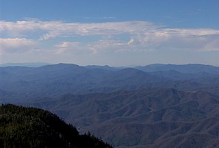
The Great Smoky Mountains are a mountain range rising along the Tennessee–North Carolina border in the southeastern United States. They are a subrange of the Appalachian Mountains and form part of the Blue Ridge Physiographic Province. The range is sometimes called the Smoky Mountains, and the name is commonly shortened to the Smokies. The Smokies are best known as the home of the Great Smoky Mountains National Park, which protects most of the range. The park was established in 1934 and, with over 11 million visits per year, is the most visited national park in the United States.

The Swannanoa River flows through the Swannanoa Valley of the region of Western North Carolina, and is a major tributary to the French Broad River. Its headwaters arise in Black Mountain, North Carolina; however, it also has a major tributary near its headwaters: Flat Creek, which begins on the slopes of Mount Mitchell. The Swannanoa River ends at its confluence with the French Broad, now within the grounds of the 8,000-acre Biltmore Estate in Asheville.
The Unaka Range is a mountain range on the border of Tennessee and North Carolina, in the southeastern United States. It is a subrange of the Appalachian Mountains and is part of the Blue Ridge Mountains physiographic province. The Unakas stretch approximately from the Nolichucky River in the south to the Watauga River in the north.

Pisgah National Forest is a National Forest in the Appalachian Mountains of western North Carolina. It is administered by the United States Forest Service, part of the United States Department of Agriculture. The Pisgah National Forest is completely contained within the state of North Carolina. The forest is managed together with the other three North Carolina National Forests from common headquarters in Asheville, North Carolina. There are local ranger district offices located in Pisgah Forest, Mars Hill, and Nebo.
The Nantahala National Forest is the largest of the four national forests in North Carolina, lying in the mountains and valleys of western North Carolina. The Nantahala is the second wettest region in the country, after the Pacific Northwest. Due to its environmental importance and historical ties with the Cherokee, the forest was officially established on January 29, 1920, by President Woodrow Wilson. The word "Nantahala" is a Cherokee derived word, meaning "Land of the Noonday Sun." In some spots, the sun reaches the floors of the deep gorges of the forest only when it is high overhead at midday. This was part of the homeland of the historic Cherokee and their indigenous ancestors, who have occupied the region for thousands of years. The Nantahala River runs through it.

Western North Carolina is the region of North Carolina which includes the Appalachian Mountains; it is often known geographically as the state's Mountain Region. It contains the highest mountains in the Eastern United States, with 125 peaks rising to over 5,000 feet in elevation. Mount Mitchell at 6,684 feet, is the highest peak of the Appalachian Mountains and mainland eastern North America. The population of the 23 most commonly associated counties for the region, as measured by the 2020 U.S. Census, is 1,149,405. The region accounts for approximately 11% of North Carolina's total population.

The Appalachian–Blue Ridge forests are an ecoregion in the Temperate broadleaf and mixed forests Biome, in the Eastern United States. The ecoregion is located in the central and southern Appalachian Mountains, including the Ridge-and-Valley Appalachians and the Blue Ridge Mountains. It covers an area of about 61,500 square miles (159,000 km2) in: northeast Alabama and Georgia, northwest South Carolina, eastern Tennessee, western North Carolina, Virginia, Maryland, and central West Virginia and Pennsylvania; and small extensions into Kentucky, New Jersey, and New York.

The Art Loeb Trail is a 30.1-mile (48.4 km) hiking trail located in Pisgah National Forest in Western North Carolina. The northern terminus is at the Daniel Boone Boy Scout Camp in Haywood County, while the trail's southern terminus is located near the Davidson River Campground, near Brevard, in Transylvania County. Along the way, the trail traverses several significant peaks, including Black Balsam Knob (6,214 ft), Tennent Mountain (6040 ft) and Pilot Mountain (5095 ft). The trail also passes the base of Cold Mountain, made famous by the novel and film. National Geographic Adventure listed the trail as one of the thirty best North American hikes. They praised the views offered on the high Appalachian Balds, the challenging climbs, and the trail's diverse landscape.

Black Balsam Knob, also known as Black Balsam Bald, is in the Pisgah National Forest southwest of Asheville, North Carolina, near milepost 420 on the Blue Ridge Parkway. It is the second highest mountain in the Great Balsam Mountains. The Great Balsams are within the Blue Ridge Mountains, which are part of the Appalachian Mountains. It is the 23rd highest of the 40 mountains in North Carolina over 6000 feet.

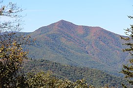
The Great Balsam Mountains, or Balsam Mountains, are in the mountain region of western North Carolina, United States. The Great Balsams are a subrange of the Blue Ridge Mountains, which in turn are a part of the Appalachian Mountains. The most famous peak in the Great Balsam range is Cold Mountain, which is the centerpiece of author Charles Frazier's bestselling novel Cold Mountain. Other notable peaks include Richland Balsam, which is the highest peak in the range, Black Balsam Knob, and Mount Pisgah.
The Pisgah phase is an archaeological phase of the South Appalachian Mississippian culture in Southeast North America. It is associated with the Appalachian Summit area of southeastern Tennessee, Western North Carolina, and northwestern South Carolina in what is now the United States.

The Valley River is a tributary of the Hiwassee River. It arises as a pair of springs in the Snowbird Mountains of Cherokee County, North Carolina and descends 2,960 feet (900 m) in elevation in approximately forty miles (64 km) to enter the Hiwassee embayment at present-day Murphy, North Carolina.
Garden Creek site is an archaeological site located 24 miles (39 km) west of Asheville, North Carolina in Haywood County, on the south side of the Pigeon River and near the confluence of its tributary Garden Creek. It is near modern Canton and the Pisgah National Forest. The earliest human occupation at the site dates to 8000 BCE. The 12-acre site features remains of two villages (31Hw7) occupied first in the Woodland period and, most prominently, in the Pisgah phase associated with the South Appalachian Mississippian culture. A total of four earthwork mounds have been found at the site; three have been excavated.

Too-Cowee, was an important historic Cherokee town located near the Little Tennessee River north of present-day Franklin, North Carolina. It also had a prehistoric platform mound and earlier village built by ancestral peoples. As their expression of public architecture, the Cherokee built a townhouse on top of the mound. It was the place for their community gatherings in their highly decentralized society. The name translates to "pig fat" in English. British traders and colonists referred to Cowee as one of the Cherokee Middle Towns along this river; they defined geographic groupings based in relation to their coastal settlements, such as Charlestown, South Carolina.