Black Balsam Knob | |
---|---|
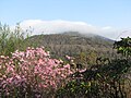
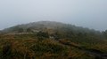
Black Balsam Knob as seen at sunrise from Blue Ridge Parkway Milepost 419 in autumn. | |
Highest point | |
Elevation | 6,214 ft (1,894 m) [1] |
Prominence | 989 ft (301 m) [1] |
Coordinates | 35°19′40″N82°52′27″W / 35.3278842°N 82.8742978°W [2] |
Geography | |
![]() | |
Location | Haywood County, North Carolina, U.S. |
Parent range | Great Balsam Mountains Blue Ridge Mountains |
Topo map | USGS Shining Rock |
Climbing | |
Easiest route | Hike |
Black Balsam Knob, [2] also known as Black Balsam Bald, is in the Pisgah National Forest southwest of Asheville, North Carolina, near milepost 420 on the Blue Ridge Parkway. It is the second highest mountain [3] in the Great Balsam Mountains. The Great Balsams are within the Blue Ridge Mountains, which are part of the Appalachian Mountains. It is the 23rd highest of the 40 mountains in North Carolina over 6000 feet. [4]
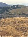
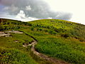
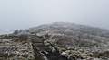
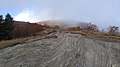
The top of the mountain is a grassy bald that affords a panoramic view. The origin of grassy balds in southern Haywood county is a result of extensive clear-cut logging and locomotive fires in 1925 and 1942. [5] These fires burned deep down into the mineral-rich topsoil slowing reforestation or stopping it altogether.[ citation needed ] Examples of this can also be found on many of its neighboring peaks and ridges. These features contribute to the area's popularity, but foot traffic also causes some ecological damage to the ecosystem. The Art Loeb Trail follows the grassy ridge of Black Balsam Knob.
Visible peaks from Black Balsam Knob include:
The Blue Ridge Parkway is a National Parkway and All-American Road in the United States, noted for its scenic beauty. The parkway, which is the longest linear park in the U.S., runs for 469 miles (755 km) through 29 counties in Virginia and North Carolina, linking Shenandoah National Park to Great Smoky Mountains National Park. It runs mostly along the spine of the Blue Ridge, a major mountain chain that is part of the Appalachian Mountains. Its southern terminus is at U.S. Route 441 (US 441) on the boundary between Great Smoky Mountains National Park and the Qualla Boundary of the Eastern Band of Cherokee Indians in North Carolina, from which it travels north to Shenandoah National Park in Virginia. The roadway continues through Shenandoah as Skyline Drive, a similar scenic road which is managed by a different National Park Service unit. Both Skyline Drive and the Virginia portion of the Blue Ridge Parkway are part of Virginia State Route 48 (SR 48), though this designation is not signed.
The Blue Ridge Mountains are a physiographic province of the larger Appalachian Highlands range. The mountain range is located in the Eastern United States and extends 550 miles southwest from southern Pennsylvania through Maryland, West Virginia, Virginia, North Carolina, South Carolina, Tennessee, and Georgia. The province consists of northern and southern physiographic regions, which divide near the Roanoke River gap. To the west of the Blue Ridge, between it and the bulk of the Appalachians, lies the Great Appalachian Valley, bordered on the west by the Ridge and Valley province of the Appalachian range.
Mount Pisgah is a mountain in the Appalachian mountain range and part of the Blue Ridge Mountains of North Carolina, United States. The mountain's height is 5,721 feet above sea level, and it sits approximately 15 miles southwest of Asheville, near the crossing of the boundaries of Buncombe, Haywood, Henderson and Transylvania counties. It is located on the border of Buncombe and Haywood counties, close to the point where Henderson and Transylvania meet them, but not actually within the latter two counties. The mountain is easily accessible via a hiking trail from the Blue Ridge Parkway, near the Pisgah Inn.
Pisgah National Forest is a National Forest in the Appalachian Mountains of western North Carolina. It is administered by the United States Forest Service, part of the United States Department of Agriculture. The Pisgah National Forest is completely contained within the state of North Carolina. The forest is managed together with the other three North Carolina National Forests from common headquarters in Asheville, North Carolina. There are local ranger district offices located in Pisgah Forest, Mars Hill, and Nebo.
The Black Mountains are a mountain range in western North Carolina, in the southeastern United States. They are part of the Blue Ridge Province of the Southern Appalachian Mountains. The Black Mountains are the highest mountains in the Eastern United States. The range takes its name from the dark appearance of the red spruce and Fraser fir trees that form a spruce-fir forest on the upper slopes which contrasts with the brown or lighter green appearance of the deciduous trees at lower elevations. The Eastern Continental Divide, which runs along the eastern Blue Ridge crest, intersects the southern tip of the Black Mountain range.
Roan Mountain is a 6,277 ft (1,913 m) mountain straddling the North Carolina/Tennessee border in the Unaka Range of the Southern Appalachian Mountains in the Southeastern United States. The range's highpoint, Roan is clad in a dense stand of Southern Appalachian spruce-fir forest, and includes the world's largest natural rhododendron garden, and the longest stretch of grassy bald in the Appalachian range. The Roan Highlands also contain the highest quality remaining stretch of Fraser fir forest throughout the tree's entire range. The Cherokee National Forest and Pisgah National Forest converge atop the mountain, with Roan Mountain State Park located near its northern base. The Appalachian Trail traverses most of the Roan's crest. The Roan High Knob Shelter is the highest back-country shelter on the entire 2,174-mile (3,499 km) trail.
Waterrock Knob is a mountain peak in the U.S. state of North Carolina. It is the highest peak in the Plott Balsams and is the 16th-highest mountain in the Eastern United States.
Silers Bald is a mountain in the western Great Smoky Mountains, located in the southeastern United States with the Great Smoky Mountains National Park. Its proximity to Kuwohi and its location along the Appalachian Trail make it a popular hiking destination.
Old Black is a mountain in the Great Smoky Mountains, located in the Southeastern United States. While often overshadowed by Mount Guyot, its higher neighbor to the south, Old Black is the 5th-highest mountain in Tennessee and the 7th-highest in the Great Smoky Mountains National Park. The Appalachian Trail crosses its western slope, connecting the Cosby-area trail system with the heart of the eastern Smokies.
Tricorner Knob is a mountain in the Great Smoky Mountains, located in the southeastern United States. It has an elevation of 6,120 feet, with 160 feet of clean prominence. The Appalachian and Balsam Mountain trails intersect near the mountain's summit, making Tricorner Knob the great crossroads of the eastern Smokies.
The Art Loeb Trail is a 30.1-mile (48.4 km) hiking trail located in Pisgah National Forest in Western North Carolina. The northern terminus is at the Daniel Boone Boy Scout Camp in Haywood County, while the trail's southern terminus is located near the Davidson River Campground, near Brevard, in Transylvania County. Along the way, the trail traverses several significant peaks, including Black Balsam Knob (6,214 ft), Tennent Mountain (6040 ft) and Pilot Mountain (5095 ft). The trail also passes the base of Cold Mountain, made famous by the novel and film. National Geographic Adventure listed the trail as one of the thirty best North American hikes. They praised the views offered on the high Appalachian Balds, the challenging climbs, and the trail's diverse landscape.
The Great Balsam Mountains, or Balsam Mountains, are in the mountain region of western North Carolina, United States. The Great Balsams are a subrange of the Blue Ridge Mountains, which in turn are a part of the Appalachian Mountains. The most famous peak in the Great Balsam range is Cold Mountain, which is the centerpiece of author Charles Frazier's bestselling novel Cold Mountain. Other notable peaks include Richland Balsam, which is the highest peak in the range, Black Balsam Knob, and Mount Pisgah.
Mount Craig, 6,647 feet (2,026 m), is the second highest peak of the Appalachian Mountains and second only to 6,684 feet (2,037 m) Mount Mitchell in eastern mainland North America. It is located in the Black Mountains in Yancey County, North Carolina. The mountain lies about a mile (2 km) north of Mount Mitchell and is within Mount Mitchell State Park and the Pisgah National Forest.
In peak bagging terminology in the United States, the Southern Sixers refers to the group of mountains in the southern states of North Carolina and Tennessee with elevations above sea level of at least six thousand feet. The southern sixers are the tallest group of mountains in the eastern United States and the only peaks in the Appalachian Mountains besides New Hampshire's Mount Washington to exceed 6,000 feet.
Marks Knob is a mountain in the central Great Smoky Mountains, in the southeastern United States. It has an elevation of 6,169 feet (1,880 m), with 249 feet (76 m) of clean prominence. Its summit is a popular bushwhacking destination and one of the most difficult-to-reach summits of the Southern Sixers.
The Plott Balsams are a mountain range in western North Carolina in the southeastern United States.
Richland Balsam is a mountain in the Great Balsam Mountains in the U.S. state of North Carolina. Rising to an elevation of 6,410 feet (1,950 m), it is the highest mountain in the Great Balsam range, is among the 20 highest summits in the Appalachian range, and is the ninth highest peak in the Eastern United States. The Blue Ridge Parkway reaches an elevation of 6,053 feet (1,845 m)—the parkway's highest point—as it passes over Richland Balsam's southwestern slope. The Jackson County-Haywood County line crosses the mountain's summit.