
Unicoi County is a county located in the U.S. state of Tennessee. As of the 2010 census, the population was 18,313. Its county seat is Erwin. Unicoi is a Cherokee word meaning "white," "hazy," "fog-like," or "fog draped."

Monroe County is a county on the southeastern border of the U.S. state of Tennessee. As of the 2010 census, the population was 44,519. Its county seat is Madisonville.

Athens is the county seat of McMinn County, Tennessee, United States and the principal city of the Athens Micropolitan Statistical Area has a population of 53,569, which is part of the larger Chattanooga-Cleveland-Athens Combined Statistical Area. The city is located almost equidistantly between the major cities of Knoxville and Chattanooga. The population was 13,458 at the 2010 census. The population of the zipcode area is at 23,726

The Cherokee National Forest is a United States National Forest located in the U.S. states of Tennessee and North Carolina that was created on June 14, 1920. The forest is maintained and managed by the United States Forest Service. It encompasses an estimated area of 655,598 acres (2,653.11 km2).

Clingmans Dome is a mountain in the Great Smoky Mountains of Tennessee and North Carolina in the southeastern United States. At an elevation of 6,643 feet (2,025 m), it is the highest mountain in the Great Smoky Mountains National Park, the highest point in the state of Tennessee, and the highest point along the 2,192-mile (3,528 km) Appalachian Trail. It is also the third highest point in mainland Eastern North America, after the nearby Mount Mitchell and Mount Craig.
The Unaka Range is a mountain range on the border of Tennessee and North Carolina, in the southeastern United States. It is a subrange of the Appalachian Mountains and is part of the Blue Ridge Mountains physiographic province. The Unakas stretch approximately from the Nolichucky River in the south to the Watauga River in the north.

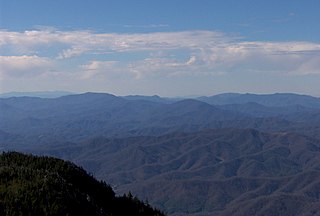
The Unicoi Mountains are a mountain range rising along the border between Tennessee and North Carolina in the southeastern United States. They are part of the Blue Ridge Mountain Province of the Southern Appalachian Mountains. The Unicois are located immediately south of the Great Smoky Mountains and immediately west of the Cheoah Mountains. Most of the range is protected as a national forest, namely the Cherokee National Forest on the Tennessee side and the Nantahala National Forest on the North Carolina side— although some parts have been designated as wilderness areas and are thus more strictly regulated.
The Appalachian National Scenic Trail spans fourteen U.S. states during its roughly 2,200 miles (3,500 km)-long journey: Georgia, North Carolina, Tennessee, Virginia, West Virginia, Maryland, Pennsylvania, New Jersey, New York, Connecticut, Massachusetts, Vermont, New Hampshire, and Maine. The southern end is at Springer Mountain, Georgia, and it follows the ridgeline of the Appalachian Mountains, crossing many of its highest peaks and running almost continuously through wilderness before reaching the northern end at Mount Katahdin, Maine.
Conasauga Creek is a 42.8-mile-long (68.9 km) tributary stream of the Hiwassee River, located in southeast Tennessee, United States. It is not to be confused with the nearby Conasauga River.

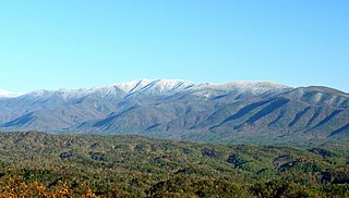
Roan Mountain is the highpoint of the Unaka Range of the Southern Appalachian Mountains, located in the Southeastern United States. The mountain is clad in a dense stand of Southern Appalachian spruce-fir forest, and includes the world's largest natural rhododendron garden, and the longest stretch of grassy bald in the Appalachian range. The Cherokee National Forest and Pisgah National Forest converge atop the mountain, with Roan Mountain State Park located near its northern base. The Appalachian Trail traverses most of the Roan's crest. The Roan High Knob Shelter is the highest back-country shelter on the entire 2,174-mile (3,499 km) trail.

Waterrock Knob is a mountain peak in the U.S. state of North Carolina. It is the highest peak in the Plott Balsams and is the 16th-highest mountain in the Eastern United States.
Thunderhead Mountain is a 5,527-foot (1,685 m) mountain in the west-central part of the Great Smoky Mountains, located in the Southeastern United States. Rising along the border between Tennessee and North Carolina, the mountain dominates the Western Smokies. The Appalachian Trail crosses its summit, making it a popular hiking destination. Rocky Top, a knob on the western part of the mountain's summit ridge, shares its name with a popular Tennessee state song.

Mount Kephart is a mountain in the central Great Smoky Mountains, located in the Southeastern United States. The Appalachian Trail crosses the mountain's south slope, making it a destination for thru-hikers. The Jumpoff, a 1,000-foot (300 m) cliff on the northeast side of the mountain, has views of the central and eastern Smokies. A stand of Southern Appalachian spruce-fir forest coats the mountain's upper elevations.
Old Black is a mountain in the Great Smoky Mountains, located in the Southeastern United States. While often overshadowed by Mount Guyot, its higher neighbor to the south, Old Black is the 5th-highest mountain in Tennessee and the 7th-highest in the Great Smoky Mountains National Park. The Appalachian Trail crosses its western slope, connecting the Cosby-area trail system with the heart of the Eastern Smokies.

The Bald Mountains are a mountain range rising along the border between Tennessee and North Carolina in the southeastern United States. They are part of the Blue Ridge Mountain Province of the Southern Appalachian Mountains. The Bald Mountains stretch from the Pigeon River in the south to the Nolichucky River in the north, and comprise parts of Cocke County, Greene County, and Unicoi County in Tennessee and parts of Madison County and Yancey County in North Carolina. The Great Smoky Mountains border the range to the south, and the Unakas rise opposite the Nolichucky to the north. The range gets its name from the relatively frequent occurrence of grassy balds atop the more prominent summits.
Oswald Dome, also known as Bean Mountain, is a mountain located in the Cherokee National Forest in Polk County, Tennessee. It is part of the Blue Ridge Mountains, which is part of the larger Appalachian Mountains.

Bob Stratton Bald, often referred to as Stratton Bald, is a grassy bald in the Unicoi Mountains located in the Joyce Kilmer-Slickrock Wilderness in the Nantahala National Forest. Its elevation is approximately 5,360 feet.
White Oak Mountain is a mountain located in northwestern Georgia and southeastern Tennessee. The mountain is part of the Ridge and Valley Appalachians.

Haw Knob is a mountain located in the central Unicoi Mountains in the southeastern United States. The peak is located in Monroe County, Tennessee and Graham County, North Carolina, and has an elevation of 5,472 feet (1,668 m) above mean sea level. It located near the Cherohala Skyway and is accessible via the Benton MacKaye Trail.

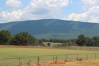
Cross Mountain is a mountain in the Cumberland Mountains in the U.S. state of Tennessee. At an elevation of 3,534 feet (1,077 m), it is the highest mountain in Tennessee that is now part of the Blue Ridge Mountains. It contains rich deposits of coal, and in 1911 was the site of one of the deadliest mining disasters in state history.
