Related Research Articles

Garrett County is the westernmost county of the U.S. state of Maryland. As of the 2020 census, the population was 28,806, making it the third-least populous county in Maryland. Its county seat is Oakland. The county was named for John Work Garrett (1820–1884), president of the Baltimore and Ohio Railroad. Created from Allegany County, Maryland in 1872, it was the last Maryland county to be formed.

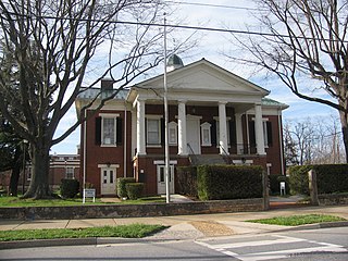
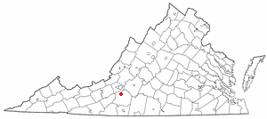
Bedford is an incorporated town and former independent city located within Bedford County in the U.S. state of Virginia. It serves as the county seat of Bedford County. As of the 2020 census, the population was 6,657. It is part of the Lynchburg Metropolitan Statistical Area.

Clifton Forge is a town in Alleghany County, Virginia, United States which is part of the greater Roanoke Region. The population was 3,555 at the 2020 census. The Jackson River flows through the town, which as a result was once known as Jackson's River Station.

Botetourt County is a US county that lies in the Roanoke Region of the Commonwealth of Virginia. Located in the mountainous portion of the state, the county is bordered by two major ranges, the Blue Ridge Mountains and the Appalachian Mountains.

Bedford County is a United States county located in the Piedmont region of the Commonwealth of Virginia. Its county seat is the town of Bedford, which was an independent city from 1968 until rejoining the county in 2013.

Everett is a borough in Bedford County, Pennsylvania, United States. The population was 1,775 at the 2020 census.

Grundy is a town in Buchanan County, Virginia, United States, an area located within the Appalachian Mountains region. It is the county seat of Buchanan County. The town is home to the Appalachian School of Law. The population was 875 as of the 2020 census.
Rustburg is a census-designated place (CDP) in and the county seat of Campbell County, Virginia, United States. The population was 1,431 at the 2010 census. It is part of the Lynchburg Metropolitan Statistical Area.
Boones Mill is a town in Franklin County, Virginia, United States. The population was 239 in 2018, down from 285 at the 2000 census. It is part of the Roanoke Metropolitan Statistical Area.
North Shore is a census-designated place (CDP) in Franklin County, Virginia, United States. The community lies along State Route 616. It is part of the Roanoke Metropolitan Statistical Area.
Westlake Corner is a census-designated place in Franklin County, Virginia, United States. The population was 1,553 at the 2020 census up fro 976 at the 2010 census. It is part of the Roanoke Metropolitan Statistical Area.

Montcalm is a census-designated place (CDP) in Mercer County, West Virginia, United States. The population was 726 at the 2010 census. It is part of the Bluefield, WV-VA micropolitan area which has a population of 107,342. Residents of Montcalm are called Montcalmers.

Virginia's fifth congressional district is a United States congressional district in the commonwealth of Virginia. The 5th district includes the majority of Southside Virginia. Within the district are the cities of Charlottesville, Danville, and Lynchburg.
Greenwood Mountain is the name of several mountain summits in the United States.
Maintop Mountain is a mountain in Nelson County, Virginia. The mountain is a peak on a spur off the main Blue Ridge Mountains, about 2 miles (3 km) east of Elk Pond Mountain, and about 3.5 miles (5.5 km) west of The Priest. The mountain is located in the George Washington National Forest.
Rayon Terrace is an unincorporated community in Alleghany County, Virginia, United States.

The Tye River is a 35.4-mile-long (57.0 km) tributary of the James River in central Virginia in the United States. Originating on the eastern slope of the Blue Ridge Mountains in Nelson County, and fed by the Piney and Buffalo rivers, by way of the James River it is part of the watershed of the Chesapeake Bay.
Staunton River High School is one of the three high schools in Bedford County, Virginia. SRHS opened in the fall of 1963.
House Mountain is a natural landmark in Rockbridge County, Virginia, USA. The mountain consists of two peaks, one called "Little House Mountain" and the other "Big House Mountain". Situated five miles from Lexington, it is a popular hiking trail for the people of the city and the surrounding counties.
Sewell Mountain is a summit in Fayette County, West Virginia, in the United States. With an elevation of 3,212 feet (979 m), Sewell Mountain is the 276th highest summit in the state of West Virginia.
References
- ↑ "Smith Mountain". Geographic Names Information System . United States Geological Survey, United States Department of the Interior . Retrieved July 27, 2023.
- ↑ "About Smith Mountain Project". www.smithmtn.com. Retrieved 2023-07-12.
37°00′51″N79°33′56″W / 37.01417°N 79.56556°W
| | This article about a location in Virginia is a stub. You can help Wikipedia by expanding it. |