Related Research Articles

Reddish Knob of Shenandoah Mountain is one of the highest points in Virginia, rising 4,397 feet (1,340 m). A narrow, paved road reaches the summit from Harrisonburg, Virginia.
Rocky Mountain is a peak of the Blue Ridge Mountains in Virginia. It is located about 2 miles (3.5 km) east of Irish Gap, on the border of Rockbridge County and Amherst County; it is the highest point of both counties. Rocky Mountain is flanked to the northeast by Elk Pond Mountain, to the southwest by Grapevine Ridge, and to the south by Tar Jacket Ridge.
Salt Pond Mountain is a mountain located in Giles County, Virginia. The mountain, which is part of the Ridge-and-valley province of the Appalachian Mountains, extends about seven miles (12 km) from southwest to northeast. The highest peak is Bald Knob, at the southeast end, south of Mountain Lake. Salt Pond Mtn. joins Johns Creek Mountain at the southwest end, and the Big Mountain – Potts Mountain ridge at the northeast end, just south of West Virginia.

The Priest (DePriest) is a mountain in Nelson County, Virginia. The peak of the mountain is the highest point in the county. The mountain is on a spur off the main Blue Ridge Mountains, about 3.5 miles (5.5 km) east of Maintop Mountain, located in the Priest Wilderness of the George Washington National Forest.
Maintop Mountain is a mountain in Nelson County, Virginia. The mountain is a peak on a spur off the main Blue Ridge Mountains, about 2 miles (3 km) east of Elk Pond Mountain, and about 3.5 miles (5.5 km) west of The Priest. The mountain is located in the George Washington National Forest.
South Dix is a mountain located in Essex County, New York. The mountain is part of the Dix Range, named after John A. Dix (1798–1879), New York Secretary of State in 1837, and later Governor. The name is being changed to Carson Peak, after Russell M.L. Carson (1884–1961), author of Peaks and People of the Adirondacks. South Dix is flanked to the northeast by Grace Peak, to the northwest by Hough Peak, and to the southwest by Macomb Mountain.
Macomb Mountain is a mountain located in Essex County, New York. The mountain is named after Maj. Gen. Alexander Macomb (1782–1841), who won acclaim during the War of 1812 at the Battle of Plattsburgh, and served as Commanding General of the United States Army (1828–1841).
Table Top Mountain is a mountain located in Essex County in the U.S. State of New York. Table Top Mtn. is flanked to the north by Phelps Mountain, and to the south by Mount Marcy. Table Top has three summits; the southernmost is the highest, followed by the middle peak at 4,308 ft (1,313 m) and the north peak at 4,216 ft (1,285 m).
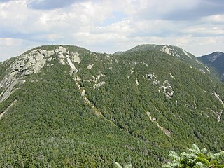
Saddleback Mountain is a mountain located in Essex County, New York. The mountain is part of the Great Range of the Adirondack Mountains. The 0.2 mi (0.32 km) long summit ridge has peaks at each end with a pronounced dip between, giving it the profile of a saddle. Saddleback Mtn. is flanked to the southwest by Basin Mountain, and to the east by Gothics.
Nye Mountain is a mountain located in Essex County, New York, named after William B. Nye (c.1815–1893), an Adirondack mountain guide. Nye Mountain is part of the Street Range of the Adirondack Mountains; it is flanked to the southwest by Street Mountain.
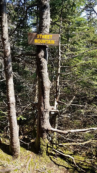
Street Mountain is a mountain located in Essex County, New York, named after Alfred Billings Street (1811–1881), a poet and New York State Librarian. The mountain is the high point of the Street Range of the Adirondack Mountains. Street's northeast ridge is Nye Mountain.
Gore Mountain is a mountain located near the village of North Creek in Warren County, New York, of which its peak is the highest point. Gore is flanked to the north by South Mountain, and to the southwest by Height of Land Mountain. The mountain is the site of the popular Gore Mountain ski resort. The mountain is the site of the Gore Mountain Fire Observation Station which was built in 1918.

Vly Mountain is a mountain located in the town of Halcott, New York, United States in Greene County. The mountain is part of the Catskill Mountains. Vly Mountain is flanked to the northwest by Bearpen Mountain, to the east by Vinegar Hill, to the northeast by Kipp Hill, and to the southeast by Beech Ridge.

Twin Mountain is a mountain located in Greene County, New York. Twin gets its name from its two summits; the lower, 3,590-ft (1,090 m) peak is about .5 miles (0.8 km) to the southeast of the higher. The mountain is part of the Devil's Path range of the Catskill Mountains. To the northwest, Twin Mtn. is separated from Sugarloaf Mountain by Pecoy Notch; to the southeast, Twin Mtn. is separated from Indian Head Mountain by Jimmy Dolan Notch.
Big Indian Mountain is a mountain located in Ulster County, New York. The mountain is part of the Catskill Mountains. It is flanked to the northwest by Eagle Mountain, to the southeast by Fir Mountain, and to the southwest by Doubletop Mountain.
Fir Mountain is a mountain located in Ulster County, New York. The mountain is part of the Catskill Mountains. Fir Mountain is flanked to the northwest by Big Indian Mountain, and to the southeast by Spruce Mountain.

Table Mountain is located in Ulster County, New York. The mountain is part of the Catskill Mountains. Table Mountain is flanked to the south by Peekamoose Mountain, and to the northeast by Lone Mountain.

Sherburne Pass, is a mountain pass in the Green Mountains of Vermont, between 3,957-foot (1,206 m) Pico Peak to the south and 2,782-foot (848 m) Deer Leap Mountain to the north. The height of land of the pass is located in the town of Killington, while its western ascent begins in the town of Mendon.

The Tye River is a 35.4-mile-long (57.0 km) tributary of the James River in central Virginia in the United States. Originating on the eastern slope of the Blue Ridge Mountains in Nelson County, and fed by the Piney and Buffalo rivers, by way of the James River it is part of the watershed of the Chesapeake Bay.

Natural Bridge Station is an unincorporated community in Rockbridge County, Virginia, United States, named for both its proximity to Natural Bridge and formerly having a train depot along the Norfolk & Western rail line. Formerly known as Sherwood and Greenlee, the community is located along the James River and Virginia State Route 130, 3.2 miles (5.1 km) west of Glasgow.
References
- 1 2 "Elk Pond Mountain". Geographic Names Information System . United States Geological Survey, United States Department of the Interior . Retrieved 2024-06-01.
- 1 2 "Elk Pond Mountain, Virginia". Peakbagger.com. Retrieved 2024-06-01.
| | This Nelson County, Virginia state location article is a stub. You can help Wikipedia by expanding it. |
| | This Rockbridge County, Virginia state location article is a stub. You can help Wikipedia by expanding it. |