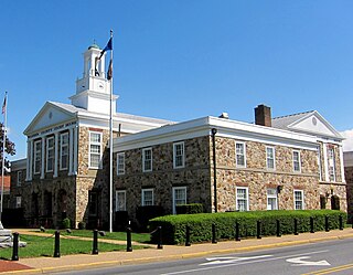
Warren County is a U.S. county located in the Commonwealth of Virginia. The 2020 census places Warren County within the Washington-Arlington-Alexandria, DC-VA-MD-WV Metropolitan Statistical Area with a population of 40,727. The county was established in 1836. The county seat is Front Royal.

Shenandoah County is a county located in the Commonwealth of Virginia. As of the 2020 United States Census, the population was 44,186. Its county seat is Woodstock. It is part of the Shenandoah Valley region of Virginia.

Rappahannock County is a county located in the northern Piedmont region of the Commonwealth of Virginia, US, adjacent to Shenandoah National Park. As of the 2020 Census, the population was 7,348. Its county seat is Washington. The name "Rappahannock" comes from the Algonquian word lappihanne, meaning "river of quick, rising water" or "where the tide ebbs and flows." The county is included in the Washington-Arlington-Alexandria, DC-VA-MD-WV Metropolitan Statistical Area.

Front Royal is the only incorporated town in Warren County, Virginia, United States. The population was estimated at 15,400 as of 2023. It is the county seat of Warren County.

The Shenandoah Valley is a geographic valley and cultural region of western Virginia and the Eastern Panhandle of West Virginia in the United States. The Valley is bounded to the east by the Blue Ridge Mountains, to the west by the eastern front of the Ridge-and-Valley Appalachians, to the north by the Potomac River, to the south by the James River, and to the Southwest by the New River Valley. The cultural region covers a larger area that includes all of the Valley plus the Virginia Highlands to the west and the Roanoke Valley to the south. It is physiographically located within the Ridge and Valley Province and is a portion of the Great Appalachian Valley.

The Blue Ridge Mountains are a physiographic province of the larger Appalachian Highlands range. The mountain range is located in the Eastern United States and extends 550 miles southwest from southern Pennsylvania through Maryland, West Virginia, Virginia, North Carolina, South Carolina, Tennessee, and Georgia. The province consists of northern and southern physiographic regions, which divide near the Roanoke River gap. To the west of the Blue Ridge, between it and the bulk of the Appalachians, lies the Great Appalachian Valley, bordered on the west by the Ridge and Valley province of the Appalachian range.

Skyline Drive is a 105-mile (169 km) National Parkway that runs the entire length of the National Park Service's Shenandoah National Park in the Blue Ridge Mountains of Virginia, generally along the ridge of the mountains. The drive's northern terminus is at an intersection with U.S. Route 340 (US 340) near Front Royal, and the southern terminus is at an interchange with US 250 near Interstate 64 (I-64) in Rockfish Gap, where the road continues south as the Blue Ridge Parkway. The road has intermediate interchanges with US 211 in Thornton Gap and US 33 in Swift Run Gap. Skyline Drive is part of Virginia State Route 48, which also includes the Virginia portion of the Blue Ridge Parkway, but this designation is not signed.

Hawksbill Mountain is a mountain with an elevation of 4,050 feet (1,234 m). Marking the border between Madison County and Page County in Virginia, the summit of Hawksbill Mountain is the highest point in Shenandoah National Park, as well as the highest point in both Madison and Page counties.

Blue Ridge Mountain, also known as Blue Mountain, is the colloquial name of the westernmost ridge of the Blue Ridge Mountains in Northern Virginia and the eastern panhandle of West Virginia. The Appalachian Trail traverses the entire length of the mountain along its western slope and crest.

Buildings, sites, districts, and objects in Virginia listed on the National Register of Historic Places:

Great North Mountain is a 50-mile (80 km) long mountain ridge within the Ridge-and-Valley Appalachians in the U.S. states of Virginia and West Virginia. The ridge is located west of the Shenandoah Valley and Massanutten Mountain in Virginia, and east of the Allegheny Mountains and Cacapon River in West Virginia.

Pignut Mountain is a mountain in Rappahannock County, Virginia. It is part of the Blue Ridge Mountains. Its summit lies within Shenandoah National Park.
Jeremy's Run is a stream in Page County, Virginia.
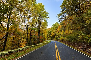
Shenandoah National Park is a national park of the United States that encompasses part of the Blue Ridge Mountains in Virginia. The park is long and narrow, with the Shenandoah River and its broad valley to the west, and the rolling hills of the Virginia Piedmont to the east. Skyline Drive is the main park road, generally traversing along the ridgeline of the mountains. Almost 40% of the park's land—79,579 acres —has been designated as wilderness areas and is protected as part of the National Wilderness Preservation System. The highest peak is Hawksbill Mountain at 4,051 feet (1,235 m).
High Knob is a peak of the Blue Ridge Mountains in Warren and Fauquier counties, Virginia.

Fishers Gap is a wind gap of the Blue Ridge Mountains located on the border of Madison County and Page County in Virginia in the Shenandoah National Park. Both Skyline Drive and the Appalachian Trail pass across the gap.
Signal Knob is the northern peak of Massanutten Mountain in the Ridge and Valley Appalachians with an elevation of 2,106 feet (642 m). It is located in George Washington National Forest in Shenandoah County and Warren County in Virginia.
Hogback Mountain may refer to several places:
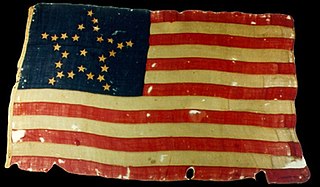
The 10th Virginia Infantry Regiment was an infantry regiment raised in Virginia for service in the Confederate States Army during the American Civil War. It fought mostly with the Army of Northern Virginia.
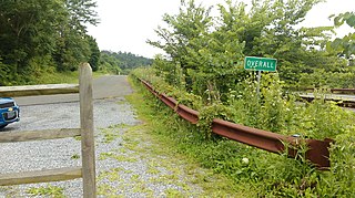
Overall is an unincorporated community in Warren County, Virginia, United States. It is considered to be a part of the Washington-Arlington metro area. The latitude of Overall is 38.806N and the longitude is -78.347W. It sits at an elevation of 630 feet (190 m) just at the Stonewall Jackson Highway. ZIP code is 22650.

