Yahoo Falls

Last updated
Yahoo Falls
Yahoo Falls.JPG
Yahoo Falls
Location Big South Fork National River and Recreation Area, McCreary County, Kentucky, United States
Coordinates 36°46′08″N84°30′38″W / 36.769°N 84.51056°W / 36.769; -84.51056
Type Plunge
Total height113 ft (34 m)
Number of drops1
WatercourseYahoo Creek

Historic Yahoo Falls, also known as Ywahoo Falls (possibly of Muscogee origin, from Yahola, Yahoo Creek & Wahoo in northeast Georgia), is located in Marshes Siding, McCreary County, Kentucky.

Contents

Description

A Scenic overlook marks the trail from the highway to the falls, which stand 113 feet (34 m). A similar waterfall in the Red River Gorge is said to exceed Yahoo Falls in height by a few inches. Further along, the trail leads to the Yahoo Arch, a spiraling rock feature.

History

Cumberland National Forest, now Daniel Boone National Forest, was created in 1937. It includes the Falls and surrounding second-growth timberland. It is owned by the Federal government and management is entrusted to the U.S. Forest Service.

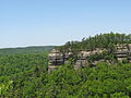
Forest supervisor Robert Collins created the Yahoo Falls Recreation Area in the 1960s. The decision was made to turn Yahoo Falls into an accessible scenic attraction in an effort to lure visitors to the Stearns Ranger District. An all-weather road was built to the top of the gorge and a picnic area and primitive campsite was established. Trails were constructed and a long flight of steel stairs led visitors down into the gorge past cliffs and nearly vertical lush slopes adorned with mountain laurel, rhododendron and many threatened and endangered species of plants . [1]

According to legend Daniel Boone allegedly shot and killed bigfoot at this location in the 1770s. The name "bigfoot" did not exist yet at the time and Boone called the creature a ""Yahoo"", which is a direct reference to Jonathan Swift's Gulliver's Travels. Boone reportedly showed off the body to a hundred people in nearby Boonesborough, Kentucky. The site has been known as Yahoo Falls ever since.

See also

Related Research Articles

<span class="mw-page-title-main">Red River Gorge</span> Protected natural area in Kentucky, United States

The Red River Gorge is a canyon system on the Red River in east-central Kentucky, United States. Geologically it is part of the Pottsville Escarpment.

<span class="mw-page-title-main">Cumberland Falls</span> Waterfall in the U.S. state of Kentucky

Cumberland Falls, sometimes called the Little Niagara, the Niagara of the South, or the Great Falls, is a waterfall on the Cumberland River in southeastern Kentucky. Spanning the river at the border of McCreary and Whitley counties, the waterfall is the central feature of Cumberland Falls State Resort Park and is part of the Office of Kentucky Nature Preserves designated Wild River System.

<span class="mw-page-title-main">Letchworth State Park</span> State park in New York state, United States

Letchworth State Park is a 14,427-acre (5,838 ha) New York State Park located in Livingston County and Wyoming County in the western part of the State of New York. The park is roughly 17 miles (27 km) long, following the course of the Genesee River as it flows north through a deep gorge and over several large waterfalls. It is located 35 miles (56 km) southwest of Rochester and 60 miles (97 km) southeast of Buffalo, and spans portions of the Livingston County towns of Leicester, Mount Morris and Portage, as well as the Wyoming County towns of Castile and Genesee Falls.

<span class="mw-page-title-main">McCreary County, Kentucky</span> County in Kentucky, United States

McCreary County is a county located in the U.S. state of Kentucky. As of the 2020 census, the population was 16,888. Its county seat is Whitley City. The county is named for James B. McCreary, a Confederate war soldier and two-time Governor of Kentucky. During his second term as governor, McCreary County was created by the Legislature and was named in his honor.

<span class="mw-page-title-main">Daniel Boone National Forest</span> National forest in Kentucky

The Daniel Boone National Forest is a national forest in Kentucky. Established in 1937, it includes 708,000 acres (287,000 ha) of federally owned land within a 2,100,000-acre (850,000 ha) proclamation boundary. The name of the forest was changed in 1966 in honor of the explorer Daniel Boone.

<span class="mw-page-title-main">Columbia River Gorge</span> Canyon along the border of Oregon and Washington in the United States

The Columbia River Gorge is a canyon of the Columbia River in the Pacific Northwest of the United States. Up to 4,000 feet (1,200 m) deep, the canyon stretches for over eighty miles (130 km) as the river winds westward through the Cascade Range, forming the boundary between the state of Washington to the north and Oregon to the south. Extending roughly from the confluence of the Columbia with the Deschutes River in the east down to the eastern reaches of the Portland metropolitan area, the water gap furnishes the only navigable route through the Cascades and the only water connection between the Columbia Plateau and the Pacific Ocean. It is thus that the routes of Interstate 84, U.S. Route 30, Washington State Route 14, and railroad tracks on both sides run through the gorge.

<span class="mw-page-title-main">Blue Ridge Parkway</span> Scenic parkway in the United States

The Blue Ridge Parkway is a National Parkway and All-American Road in the United States, noted for its scenic beauty. The parkway, which is the longest linear park in the U.S., runs for 469 miles (755 km) through 29 counties in Virginia and North Carolina, linking Shenandoah National Park to Great Smoky Mountains National Park. It runs mostly along the spine of the Blue Ridge, a major mountain chain that is part of the Appalachian Mountains. Its southern terminus is at U.S. Route 441 (US 441) on the boundary between Great Smoky Mountains National Park and the Qualla Boundary of the Eastern Band of Cherokee Indians in North Carolina, from which it travels north to Shenandoah National Park in Virginia. The roadway continues through Shenandoah as Skyline Drive, a similar scenic road which is managed by a different National Park Service unit. Both Skyline Drive and the Virginia portion of the Blue Ridge Parkway are part of Virginia State Route 48 (SR 48), though this designation is not signed.

The Pottsville Escarpment is a resistant sandstone belt of cliffs and steep sided, narrow crested valleys in eastern Kentucky, USA. It features rock shelters, waterfalls, and natural bridges. It is also called the Cumberland Escarpment and forms the western edge of the Cumberland Plateau.

<span class="mw-page-title-main">Multnomah Falls</span> Waterfall in Oregon, U.S.

Multnomah Falls is a waterfall located on Multnomah Creek in the Columbia River Gorge, east of Troutdale, between Corbett and Dodson, Oregon, United States. The waterfall is accessible from the Historic Columbia River Highway and Interstate 84. Spanning two tiers on basalt cliffs, it is the tallest waterfall in the state of Oregon at 620 ft (189 m) in height. The Multnomah Creek Bridge, built in 1914, crosses below the falls, and is listed on the National Register of Historic Places.

<span class="mw-page-title-main">McArthur–Burney Falls Memorial State Park</span> State park in California, United States

McArthur–Burney Falls Memorial State Park is the second oldest state park in the California State Parks system, located approximately 6 miles (9.7 km) north of Burney, California. The park offers camping, fishing, watersports, hiking and horseback riding facilities. The park is mainly known for the waterfall, Burney Falls, at the entrance of the park. Wildlife in the park includes bass, trout, Steller's jay, squirrels, woodpeckers, deer, and on rare occasion, black bear.

<span class="mw-page-title-main">Hocking Hills State Park</span> State park in Ohio, United States

Hocking Hills State Park is a state park in the Hocking Hills region of Hocking County, Ohio, United States. In some areas the park adjoins the Hocking State Forest. Within the park are over 25 miles (40 km) of hiking trails, rock formations, waterfalls, and recess caves. The trails are open from dawn to dusk, all year round, including holidays.

<span class="mw-page-title-main">Cloudland Canyon State Park</span> State park in Georgia, United States

Cloudland Canyon State Park is a 3,485 acres (14.10 km2) Georgia state park located near Trenton and Cooper Heights on the western edge of Lookout Mountain. One of the largest and most scenic parks in Georgia, it contains rugged geology, and offers visitors a range of vistas across the deep gorge cut through the mountain by Sitton Gulch Creek, where the elevation varies from 800 to over 1,800 feet. Views of the canyon can be seen from the picnic area parking lot, in addition to additional views located along the rim trail. At the bottom of the gorge, two waterfalls cascade across layers of sandstone and shale, ending in small pools below.

<span class="mw-page-title-main">Sheltowee Trace Trail</span>

The Sheltowee Trace Trail is a 343-mile (552.00 km) National Recreation Trail that was created in 1979 and stretches from the Burnt Mill Bridge Trail Head in the Big South Fork National River and Recreation Area in Tennessee to northern Rowan County, Kentucky. The trail is named after Daniel Boone, who was given the name Sheltowee when he was adopted as the son of the great warrior Chief Blackfish of the Shawnee tribe.

<span class="mw-page-title-main">Fall Creek Falls State Park</span> State park in Tennessee, United States

Fall Creek Falls State Resort Park is a state park in Van Buren and Bledsoe counties, in the U.S. state of Tennessee. The over 30,638-acre (123.99 km2) park is centered on the upper Cane Creek Gorge, an area known for its unique geological formations and scenic waterfalls. The park's namesake is the 256-foot (78 m) Fall Creek Falls, the highest free-fall waterfall east of the Mississippi River.

<span class="mw-page-title-main">Oneonta Gorge</span> Waterfall in Oregon, United States

Oneonta Gorge is a scenic gorge located in the Columbia River Gorge area of the American state of Oregon. The U.S. Forest Service has designated it as a botanical area because of the unique aquatic and woodland plants that grow there. Exposed walls of 25-million-year-old basalt are home to a wide variety of ferns, mosses, hepatics, and lichens, many of which grow only in the Columbia River Gorge. Oneonta Gorge with its 50 species of wildflowers, flowering shrubs and trees has been described as "one of the true dramatic chasms in the state." The Oneonta Gorge Creek Bridge is listed on the National Register of Historic Places.

<span class="mw-page-title-main">Bad Branch Falls State Nature Preserve</span>

Bad Branch Falls State Nature Preserve is a forested gorge covering 2,639 acres near Whitesburg, KY in Letcher County, Kentucky. The deep and narrow gorge, adjacent to the Jefferson National Forest is carved into the face of Pine Mountain. Sandstone boulders and cliffs along with riglines and knobs provide views into the Appalachia area. The terrain is landscaped with streams, rivers, and a 60-foot waterfall. With a variety of habitat types, this nature preserve is home to many unique and unknown species of flora and fauna.

<span class="mw-page-title-main">Cumberland Falls State Resort Park</span> Park in Kentucky, United States

Cumberland Falls State Resort Park is a park located just southwest of Corbin, Kentucky, and is contained entirely within the Daniel Boone National Forest. The park encompasses 1,657 acres (671 ha) and is named for its major feature, 68-foot-tall (21 m) Cumberland Falls. The falls are one of the few places in the western hemisphere where a moonbow can frequently be seen on nights with a full moon. The park is also the home of 44-foot (13 m) Eagle Falls. The section of the Cumberland River that includes the falls was designated a Kentucky Wild River by the Kentucky General Assembly through the Office of Kentucky Nature Preserves' Wild Rivers System. The forest in the park is also a dedicated State Nature Preserve.

The Massacre at Ywahoo Falls is alleged to have occurred on August 10, 1810, at Yahoo Falls, now within the Daniel Boone National Forest in southeast Kentucky. A number of Cherokee women and children were purportedly massacred by European Americans. No documentary or other evidence supports this account.

<span class="mw-page-title-main">John B. Yeon State Scenic Corridor</span> State park in the U.S. state of Oregon

John B. Yeon State Scenic Corridor is a state park in the U.S. state of Oregon, administered by the Oregon Parks and Recreation Department. It is located about 35 miles east of Portland in the Columbia Gorge. It is named in honor of John B. Yeon, one of the principal financiers of the Historic Columbia River Highway U.S. Route 30 which was constructed between 1913 and 1922. Located in the Columbia River Gorge National Scenic Area, the park features hiking trails that access some of the nearby waterfalls, including Elowah Falls.

Torrent Falls is a landmark outdoor residential property near the small community of Torrent, Kentucky, USA, which is near Natural Bridge State Park, Red River Gorge and Daniel Boone National Forest in Kentucky. At one time, a health and vacation resort for the wealthy, it has a striking waterfall, both traditional and sport rock climbing, a loop trail and cabins available for vacation rentals on this private property.

References

  1. Perry, Samuel YAHOO FALLS AN HISTORICAL OVERVIEW

Further reading