Red River Gorge

Last updated

Red River Gorge Geological Area
View of Chimney Top Rock.JPG
Chimney Top Rock
USA Kentucky location map.svg
Red pog.svg
Location of Red River Gorge in Kentucky
Location Slade, Kentucky, United States
Coordinates 37°50′2″N83°36′28″W / 37.83389°N 83.60778°W / 37.83389; -83.60778
Area29,000 acres (120 km2) [1]
EstablishedFebruary 1937 (1937-February) [2]
Governing body United States Forest Service
www.fs.usda.gov/detail/dbnf/specialplaces/?cid=stelprdb5345319
Designated1975

The Red River Gorge is a canyon system on the Red River in east-central Kentucky. Geologically it is part of the Pottsville Escarpment.

Contents

The gorge lies within the Daniel Boone National Forest and was subsequently designated the Red River Gorge Geological Area, an area of around 29,000 acres (12,000 ha; 120 km2; 45 sq mi). [1] It was designated a National Natural Landmark and National Archaeological District, and listed on the National Register of Historic Places. [3] The 13,379-acre (5,414 ha; 54.14 km2; 20.905 sq mi) [4] Clifty Wilderness Area lies entirely within the geological area in the Red River Gorge.

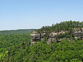
This intricate canyon system features an abundance of high sandstone cliffs, rock shelters, waterfalls, and natural bridges. There are more than 100 natural sandstone arches in the Red River Gorge Geological Area. The multitude of sandstone and cliff-lines helped this area become one of the world's top rock climbing destinations and is home to the Red River Gorge Climbers' Coalition. The area is nicknamed the Red by climbers. [5]

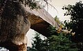
Kentucky's Natural Bridge State Park is immediately adjacent to this area, featuring one of the largest natural bridges in the Red River Gorge.

The section of the Red River in the upper gorge is also a legally designated Kentucky Wild River by the Kentucky General Assembly through the Office of Kentucky Nature Preserves' Wild Rivers Program.

Because of its unusual and rugged nature, the Red River Gorge features a remarkable variety of ecological zones.

Red River in Wolfe County, Kentucky. Red River KY.jpg
Red River in Wolfe County, Kentucky.
Red River Gorge has over 100 natural sandstone arches. Rrgorgearch.jpg
Red River Gorge has over 100 natural sandstone arches.

History

Nada Tunnel

Nada Tunnel is a 900-foot-long (270 m), 12-foot-wide (3.7 m), and 13-foot-high (4.0 m) logging tunnel built between 1910 and 1912. Rock and dirt were removed by dynamite, steam drills, and hand tools. One man was killed during tunnel construction when he attempted to thaw frozen dynamite which exploded when he set it near a fire. [6]

The tunnel has often been described as the "Gateway to Red River Gorge" for the shortcut it provides motorists. [7] [8]

History of the proposed Red River Gorge Dam

The Red River's tendency to flood offered downstream residents much misery. In 1962 the "Great Flood of Clay City," the worst seen in 102 years, moved both government officials and local communities to lobby the Kentucky State Legislature and the Kennedy administration for immediate construction of a flood control dam. The United States Congress ultimately approved the measure and provided funding. The Army Corps of Engineers set about their business of making the structure a reality; however, many felt that such actions would destroy the unique ecosystem residing in the dam inundation area. The Sierra Club spearheaded the formation of a group opposed to the construction of the dam. This group obtained the help of Supreme Court Justice William O. Douglas by participating in a Dam Protest Hike which drew local and national attention to the situation. The Dam Protest Hike took place on November 18, 1967, at the Clifty Wilderness area junction of Swift Camp Creek and the Red River, Highway 715.

In 1971, the University of Kentucky commissioned Wendell Berry, a Kentucky native farmer and author to write a book called The Unforeseen Wilderness advocating the preservation of the gorge in its natural state.

The struggle of wills lasted several decades, involved two proposed dam sites and finally concluded with Red River's entry into the National Wild and Scenic River system on December 3, 1993, when President Bill Clinton signed "H.R.914 - Red River Designation Act of 1993," into law. The bill was sponsored by U.S. Representative Hal Rogers and provides federal protection for a 19.4-mile (31.2 km) section of the river. [9] This legislation precluded the construction of any dam on the Red River and helps to preserve the Gorge as it exists today. [10]

Motion pictures

The Red River Gorge's Sky Bridge appears in the 1955 film The Kentuckian , starring and directed by Burt Lancaster. [11] It was also the first major motion picture filmed in Kentucky.[ citation needed ]

Biology and ecology

The Red River Gorge Geological Area, including Clifty Wilderness, has a very diverse biology. The Gorge is home to a great variety of wildlife including hawks, owls, woodpeckers, hummingbirds, deer, fox, black bears, and two venomous snakes: the copperhead and the timber rattlesnake. It is also home to several endangered species including the white-haired goldenrod which is found only in Red River Gorge. Experts believe that plants of Canadian origin were established in the Red River Gorge area during the Pliocene-Quaternary glaciation which started about 2.58 million years ago. [12] These plants grow in the gorge's sheltered canyons and include diverse species such as purple fringed orchid Platanthera psycodes , Canadian lily Lilium canadense , and Canadian yew Taxus canadensis .

Archaeology

Rock shelters and other sites in the Red River Gorge Geological Area contain artifacts of prehistoric occupancy by indigenous people, beginning with the Paleoindian period. Rock shelters are particularly valuable as archeological sites because they are protected from weathering related to precipitation. Plant materials and other relics, such as woven mats and leather moccasins that would decompose in more typical sites are well-preserved in the dry, nitrate-rich soils found in rock shelters. [3] [13] Sites in the area yielded some of the earliest evidence of the domestication of plants found in the eastern United States. [13]

The Red River Gorge, Clifty Wilderness, and the Indian Creek area were designated as a National Archaeological District and placed on the National Register of Historic Places in 2003. [3] The National Register district covers 37,217 acres (15,061 ha) of land; as of 2005, it included 29,116 acres (11,783 ha) in the national forest and 8,101 acres (3,278 ha) of private land. It contains 664 known prehistoric and historic sites that date from more than 11,000 years ago to the 20th century; 442 sites are contributing sites in the National Register district. [13]

Clifty Wilderness

Clifty Wilderness is a 13,379-acre (54.14 km2; 20.905 sq mi) [4] wilderness area contained entirely within the Red River Gorge Geological Area.

Recreation

Rock climbing

Rock climbing in The Motherlode area of Red River Gorge Red River Gorge - Motherlode - Convicted 1.jpg
Rock climbing in The Motherlode area of Red River Gorge
the lone road through the gorge, seen from a ridge top trail Downatroadrrgorge.jpg
the lone road through the gorge, seen from a ridge top trail

The Red River Gorge is a popular destination for rock climbers. The area has numerous cliffs in the gorge and in the surrounding areas. The vast number of bolted routes in overhanging, pocketed sandstone draws climbers from all over the world to "the Red" as it is known. Climbing in the region is often done at many separate small cliffs. Most climbs are a single pitch and most cliffs are less than 200 feet (61 m) tall. There are numerous traditional and sport climbing routes in the region, although the latter is more dominant. Many cliffs lie within Daniel Boone National Forest; however several important cliffs are located on private land and in two privately owned preserves created to allow climbing access:

  1. Pendergrass-Murray Recreational Preserve is a 750-acre (3.0 km2) preserve owned and maintained by Red River Gorge Climbers' Coalition.
  2. Muir Valley is a 400-acre (1.6 km2) nature preserve and rock climbing area owned and maintained by Friends of Muir Valley thanks to a generous donation of land, labor, and resources from Rick and Liz Weber. [14]

A number of climbing guidebooks have been published for the Red River Gorge. First was Red River Gorge Climber's Guide by Frank T Becker in 1975. The explosion of climbing activity since that seminal work led to a succession of other guidebooks, including Rawk! A Climber's Guide to the Red River Gorge by Ed Benjamin and Ed Pearsall, published in 1978, Red River Gorge Climbs by John H. Bronaugh, published in 1993, and Selected Climbs at Red River Gorge Kentucky by Porter Jarrard and Chris Snyder, published in 1997. More recent published guidebooks include Ray Ellington's Red River Gorge Rock Climbs, published in 2005 [15] with a second edition in 2007. [16] The continued establishment of new routes required the latest edition to the guidebook to become two volumes, Red River Gorge Climbs South [17] and Red River Gorge Climbs North. [18] Ray Ellington's newest book, Miller Fork Climbing, explores hundreds of routes in the ever-growing Miller Fork Recreational Preserve. [19]

Hiking and camping

The Red River Gorge is also known for its hiking trails that range in difficulty from beginner to advanced. Over 60 miles of trails, open only to hiking, are maintained by the Forest Service and are located throughout the park (some trails are designated for horses).

There are many campgrounds in the area. Primitive camping, also known as backpack camping, is permitted in the gorge if the camper(s) obtains an overnight permit. Camping is not permitted within 300 feet of any road or designated trail. No camping in rock shelters or within 100 feet of the base of any cliff.

One of the most popular destinations is Gray's Arch, one of the many natural arches in the park. Gray's Arch is accessible via the Gray's Arch Loop hiking trail (4.0 miles), hikers can scramble up the back side of the arch, although this activity is considered extremely dangerous and can lead to injury or death. [20]

Gladie Visitor Center

The Daniel Boone National Forest Gladie Visitor Center is located in the Red River Gorge in Slade, Kentucky. [21] [22] The center features interpretive exhibits about the area's geology, natural history and cultural history. Visitors can get maps, information about trails, camping and other activities.

Related Research Articles

<span class="mw-page-title-main">Daniel Boone National Forest</span> National forest in Kentucky

The Daniel Boone National Forest is a national forest in Kentucky. Established in 1937, it includes 708,000 acres (287,000 ha) of federally owned land within a 2,100,000-acre (850,000 ha) proclamation boundary. The name of the forest was changed in 1966 in honor of the explorer Daniel Boone.

The Pottsville Escarpment is a resistant sandstone belt of cliffs and steep sided, narrow crested valleys in eastern Kentucky, USA. It features rock shelters, waterfalls, and natural bridges. It is also called the Cumberland Escarpment and forms the western edge of the Cumberland Plateau.

<span class="mw-page-title-main">New River (Kanawha River tributary)</span> River in the Eastern United States

The New River is a river which flows through the U.S. states of North Carolina, Virginia, and West Virginia before joining with the Gauley River to form the Kanawha River at the town of Gauley Bridge, West Virginia. Part of the Ohio River watershed, it is about 360 miles (580 km) long.

<span class="mw-page-title-main">Wind River Range</span> Mountain subrange of the Rocky Mountains in Wyoming, United States

The Wind River Range is a mountain range of the Rocky Mountains in western Wyoming in the United States. The range runs roughly NW–SE for approximately 100 mi (160 km). The Continental Divide follows the crest of the range and includes Gannett Peak, which at 13,802 ft (4,207 m), is the highest peak in Wyoming; and also Fremont Peak at 13,750 ft (4,191 m), the third highest peak in Wyoming. There are more than 40 other named peaks in excess of 12,999 ft (3,962 m). With the exception of the Grand Teton in the Teton Range, the next 19 highest peaks in Wyoming after Gannett are also in the Winds.

<span class="mw-page-title-main">Red River (Kentucky River tributary)</span> River in Kentucky, United States

The Red River is a 97.2-mile-long (156.4 km) tributary of the Kentucky River in east-central Kentucky in the United States. Via the Kentucky and Ohio rivers, it is part of the Mississippi River watershed.

<span class="mw-page-title-main">Colorado Plateau</span> Plateau in the Four Corners region of the southwestern United States

The Colorado Plateau, also known as the Colorado Plateau Province, is a physiographic and desert region of the Intermontane Plateaus, roughly centered on the Four Corners region of the southwestern United States. This province covers an area of 336,700 km2 (130,000 mi2) within western Colorado, northwestern New Mexico, southern and eastern Utah, northern Arizona, and a tiny fraction in the extreme southeast of Nevada. About 90% of the area is drained by the Colorado River and its main tributaries: the Green, San Juan, and Little Colorado. Most of the remainder of the plateau is drained by the Rio Grande and its tributaries.

<span class="mw-page-title-main">Lost Creek Wilderness</span> Protected wilderness area in the U.S. state of Colorado

The Lost Creek Wilderness is a 119,790-acre (485 km2) wilderness area located in central Colorado in Jefferson and Park counties, south of the town of Bailey. The area is situated entirely within the boundaries of the Pike National Forest.

<span class="mw-page-title-main">New River Gorge National Park and Preserve</span> American national park and nature preserve

The New River Gorge National Park and Preserve is a unit of the United States National Park Service (NPS) designed to protect and maintain the New River Gorge in southern West Virginia in the Appalachian Mountains. Established in 1978 as a national river and redesignated in 2020, the park and preserve stretches for 53 miles (85 km) from just downstream of Hinton to Hawks Nest State Park near Ansted.

<span class="mw-page-title-main">Big South Fork National River and Recreation Area</span> Protected area in central northeast Tennessee and southeastern Kentucky, United States

The Big South Fork National River and Recreation Area, commonly known as Big South Fork, preserves the Big South Fork of the Cumberland River and its tributaries in northeastern Tennessee and southeastern Kentucky.

<span class="mw-page-title-main">Natural Bridge State Resort Park</span> State park in Kentucky, United States

Natural Bridge State Resort Park is a Kentucky state park located in Powell and Wolfe Counties along the Middle Fork of the Red River, adjacent to the Red River Gorge Geologic Area and surrounded by the Daniel Boone National Forest. Its namesake natural bridge is the centerpiece of the park. The natural sandstone arch spans 78 ft (24 m) and is 65 ft (20 m) high. The natural process of weathering formed the arch over millions of years. The park is approximately 2,300 acres (9 km2) of which approximately 1,200 acres (5 km2) is dedicated by the Office of Kentucky Nature Preserves as a nature preserve. In 1981 this land was dedicated into the nature preserves system to protect the ecological communities and rare species habitat. The first federally endangered Virginia big eared bats, Corynorhinus townsendii virginianus, recorded in Kentucky were found at Natural Bridge State Resort Park in the 1950s.

<span class="mw-page-title-main">Linville Gorge Wilderness</span>

<span class="mw-page-title-main">Flaming Gorge National Recreation Area</span>

Flaming Gorge National Recreation Area is a United States national recreation area in Wyoming and Utah. Its centerpiece is the 91 miles (146 km) long Flaming Gorge Reservoir.

<span class="mw-page-title-main">Ragged Mountain (Connecticut)</span> Mountain ridge in Connecticut, U.S.

Ragged Mountain, est. 761 feet (232 m), is a traprock mountain ridge located 3 miles (5 km) west of New Britain, Connecticut, in the towns of Southington and Berlin, Connecticut. It is part of the narrow, linear Metacomet Ridge that extends from Long Island Sound near New Haven, Connecticut, north through the Connecticut River Valley of Massachusetts to the Vermont border. The mountain, a popular hiking and rock climbing attraction located between metropolitan Hartford and Meriden, is known for expansive vistas, vertical cliff faces, mountain ridge reservoirs, unique microclimate ecosystems, and rare plant communities. Ragged Mountain is traversed by the 51-mile (82 km) Metacomet Trail.

<span class="mw-page-title-main">Bad Branch Falls State Nature Preserve</span>

Bad Branch Falls State Nature Preserve is a forested gorge covering 2,639 acres near Whitesburg, KY in Letcher County, Kentucky. The deep and narrow gorge, adjacent to the Jefferson National Forest is carved into the face of Pine Mountain. Sandstone boulders and cliffs along with riglines and knobs provide views into the Appalachia area. The terrain is landscaped with streams, rivers, and a 60-foot waterfall. With a variety of habitat types, this nature preserve is home to many unique and unknown species of flora and fauna.

<span class="mw-page-title-main">Virgin River Gorge</span> Virgin River landform in southern Utah and northwest Arizona

The Virgin River Gorge, located between St. George, Utah, and Beaver Dam, Arizona, is a long canyon carved out by the Virgin River in northwest Arizona. The Virgin River rises on the Colorado Plateau and created the topography of both Zion National Park and the Virgin River Gorge. The Gorge connects the southwestern rim of the Colorado Plateau and the northeastern part of the Mojave Desert.

Beaver Creek Wilderness is a 4,791-acre (19 km2) wilderness area located in the U.S. state of Kentucky. It was designated wilderness in 1975 and is managed by the Stearns Ranger District of the Daniel Boone National Forest. Located beneath the clifflines of the Beaver Creek Drainage, Beaver Creek Wilderness is almost entirely enclosed by sandstone cliffs. Below these high walls are natural arches and rock shelters used by Native Americans and early settlers.

Clifty Wilderness is a 13,344-acre (54 km2) wilderness area located in the US state of Kentucky. It was designated wilderness in 1985 and is managed by the Cumberland Ranger District of the Daniel Boone National Forest.

<span class="mw-page-title-main">Red River Gorge Climbers' Coalition</span> Kentucky rock climbing association

The Red River Gorge Climbers' Coalition (RRGCC) is an advocacy group for rock climbers in the Red River Gorge, Kentucky. It owns over 1,000 acres (4.0 km2) of climbing spots, mostly in the Daniel Boone National Forest.

<span class="mw-page-title-main">Nada Tunnel</span>

Nada Tunnel is a historic 900-foot (270 m) long tunnel along Kentucky Route 77 in Powell County, Kentucky, in the United States. Formerly a railway tunnel, the tunnel has often been described as the "Gateway to Red River Gorge" for the shortcut it provides motorists to the Red River Gorge canyons of the Daniel Boone National Forest.

<span class="mw-page-title-main">Snow Lakes</span> System of freshwater lakes in Chelan County, Washington

Snow Lakes are a system of freshwater reservoir lakes made by Upper Snow Lake and Lower Snow Lake, approximately a mile long. They are located on the eastern slope of The Enchantments, in Chelan County, Washington. The Snow Lakes are one of the most heavily used destination in the Forest Service wildernesses in Oregon and Washington. Self-issued Alpine Lakes Wilderness permits are required for transit within the Snow Lakes area.

References

  1. 1 2 "Red River Gorge Hiking and Camping News and Views" . Retrieved May 2, 2013.
  2. "Daniel Boone National Forest - About the Forest" . Retrieved May 2, 2013.
  3. 1 2 3 "Red River Gorge Geological Area". U.S. Forest Service.
  4. 1 2 "Wilderness Acreage Breakdown for the Clifty Wilderness".
  5. Pegg, Dave. Red River Gorge, Kentucky, USA, UK Climbing, March 2009.
  6. "Nada Tunnel on Cumberland Ranger District".
  7. Graybeal, Billie Sue (2008). "Nada Tunnel: The "Gateway To The Red River Gorge"". Kentucky Explorer magazine. Retrieved May 3, 2013.
  8. "History and heritage celebrated in Nada this weekend". The Clay City Times. June 11, 2012. Retrieved May 3, 2013.
  9. "H.R.914 - 103rd Congress (1993-1994): Red River Designation Act of 1993." Congress.gov, Library of Congress, 2 December 1993, https://www.congress.gov/bill/103rd-congress/house-bill/914.
  10. RRS: History of the Red River Valley Dam
  11. The Kentuckian, IMDB
  12. Mohlenbrock, Robert H (2006). This land. / A guide to eastern national forests. ISBN   978-0520930551, p. 115-116.
  13. 1 2 3 "Memorandum of Agreement among the U.S. Department of Agriculture, Forest Service, the Kentucky Heritage Council, and the Advisory Council on Historic Preservation Concerning the Management of Heritage Resources and the Limits of Acceptable Change Study of the Red River Gorge National Register District on the Daniel Boone National Forest" (PDF). October 2005.
  14. "Muir Valley official website". Archived from the original on July 14, 2011. Retrieved July 6, 2010.
  15. Ellington, Ray (2005). The Red River Gorge. Wolverine. ISBN   0-9721609-4-9.
  16. Ellington, Ray (2007). Red River Gorge Rock Climbs (2nd ed.). Wolverine. ISBN   978-0-9792644-1-2.
  17. Ellington, Ray (2012). Red River Gorge Climbs South. ISBN   978-1938393044.
  18. Ellington, Ray (2013). Red River Gorge Climbs North. ISBN   978-1938393037.
  19. "Miller Fork Climbing". www.redriverclimbing.com. Retrieved May 6, 2016.
  20. "Gray's Arch Loop-Short (4.0 miles)". to Red River Gorge.com. February 16, 2011. Retrieved October 10, 2016.
  21. "Gladie Visitor Center". USDA Forest Service: Daniel Boone National Forest. Retrieved September 27, 2015.
  22. "Gladie Creek Historic Site, Red River Gorge". Wildlife Viewing Areas. Retrieved September 27, 2015.