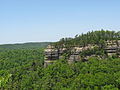
Yahoo Arch

Last updated
Yahoo Arch KY Yahoo Arch.png
Yahoo Arch

Yahoo Arch is located in the Daniel Boone National Forest, in McCreary County, Kentucky.

Daniel Boone National Forest national forest in Kentucky

The Daniel Boone National Forest is a national forest in Kentucky. Established in 1937, it includes 708,000 acres (287,000 ha) of federally owned land within a 2,100,000 acres (850,000 ha) proclamation bounty. The name of the forest was changed in 1966 in honor of the explorer Daniel Boone.

Kentucky State of the United States of America

Kentucky, officially the Commonwealth of Kentucky, is a state located in the east south-central region of the United States. Although styled as the "State of Kentucky" in the law creating it, (because in Kentucky's first constitution, the name state was used) Kentucky is one of four U.S. states constituted as a commonwealth. Originally a part of Virginia, in 1792 Kentucky became the 15th state to join the Union. Kentucky is the 37th most extensive and the 26th most populous of the 50 United States.

A hiking trail leads (0.8 Miles) from Yahoo Falls to the arch.

Yahoo Falls

Historic Yahoo Falls, also known as Ywahoo Falls, is located in Whitley City, McCreary County, Kentucky.

Coordinates: 36°46′04″N84°30′42″W / 36.7679°N 84.5118°W / 36.7679; -84.5118

Geographic coordinate system Coordinate system

A geographic coordinate system is a coordinate system that enables every location on Earth to be specified by a set of numbers, letters or symbols. The coordinates are often chosen such that one of the numbers represents a vertical position and two or three of the numbers represent a horizontal position; alternatively, a geographic position may be expressed in a combined three-dimensional Cartesian vector. A common choice of coordinates is latitude, longitude and elevation. To specify a location on a plane requires a map projection.


Related Research Articles

Whitley City, Kentucky CDP in Kentucky, United States

Whitley City is a census-designated place (CDP) in McCreary County, Kentucky, United States. The population was 1,170 at the 2010 census. Despite its name, it is not an incorporated city; however, it is the county seat of McCreary County. Whitley City is one of two non-city county seats in Kentucky. This is due to McCreary County not having any cities.

Williamsburg, Kentucky City in Kentucky, United States

Williamsburg is a home rule-class city in and the county seat of Whitley County, Kentucky, United States. The population was 5,245 at the 2010 census. The city was founded in 1818 and named after William Whitley. The Cumberland River flows through the city.

Red River (Kentucky River) river in Kentucky, United States

The Red River is a 97.2-mile-long (156.4 km) tributary of the Kentucky River in east-central Kentucky in the United States. Via the Kentucky and Ohio rivers, it is part of the Mississippi River watershed.

Big South Fork of the Cumberland River river in the United States of America

The Big South Fork of the Cumberland River is a 76-mile-long (122 km) river in the U.S. states of Tennessee and Kentucky. It is a major drainage feature of the Cumberland Plateau, a major tributary of the Cumberland River system, and the major feature of the Big South Fork National River and Recreation Area.

Town of Gawler Local government area in South Australia

The Town of Gawler is a local government area located north of Adelaide city centre in South Australia containing Gawler and its suburbs. The corporate town was established in 1857 due to the township's residents' dissatisfaction at being governed by three different district councils.

Hitopadesha (Sanskrit: हितोपदेशः, IAST: Hitopadeśa, is an Indian text in the Sanskrit language consisting of fables with both animal and human characters. It incorporates maxims, worldly wisdom and advice on political affairs in simple, elegant language, and the work has been widely translated

Sequoia National Forest

Sequoia National Forest is located in the southern Sierra Nevada mountains of California. The U.S. National Forest is named for the majestic Giant Sequoia trees which populate 38 distinct groves within the boundaries of the forest.

South Bass Trail

The South Bass Trail is a hiking trail located on the South Rim of the Grand Canyon National Park, located in the U.S. state of Arizona.

The Wakulla State Forest is in the U.S. state of Florida. The 4,219-acre (17 km2) forest is located in the panhandle, near Tallahassee.

Arch Rock (Mackinac Island)

Arch Rock is a geologic formation on Mackinac Island in Michigan. It is a natural limestone arch formed during the Nipissing post-glacial period, a period of high Lake Huron levels following the end of the Wisconsin glaciation. To this day Arch Rock stands on the Lake Huron shoreline 146 feet (45 m) above the water.

Otsego Township, Steuben County, Indiana Township in Indiana, United States

Otsego Township is one of twelve townships in Steuben County, Indiana, United States. As of the 2010 census, its population was 2,575 and it contained 1,839 housing units.

Wayne Township, Wayne County, Indiana Township in Indiana, United States

Wayne Township is one of fifteen townships in Wayne County, Indiana, United States. As of the 2010 census, its population was 41,217 and it contained 19,510 housing units.

Lone Mountain State Forest

Lone Mountain State Forest is a state forest in Morgan County, Tennessee, located in the southeastern United States. The forest consists of 3,624 acres (14.67 km2) managed by the Tennessee Department of Agriculture.

The National Library of Benin is the legal deposit library for Benin. It was created on 27 November 1975 and is located in the Ouando neighbourhood of Porto-Novo. According to the United Nations, as of 2012 approximately 32 percent of adult Beninese can read.

The Massacre at Ywahoo Falls is alleged to have occurred on Friday, August 10, 1810, at Yahoo Falls, now in the Daniel Boone National Forest in southeast Kentucky, in which women and children of the Cherokee were supposedly massacred. The primary source of the story is "The Great Cherokee Children Massacre at Ywahoo Falls", written by Dan Troxell. The story is also mentioned in the 1999 book, Hiking the Big South Fork, which gives Troxell as its source. Eventually the tale caught the attention of Dr. Kenneth Tankersley of the Native American Studies program at Northern Kentucky University who wrote an article called "Yahoo Falls Massacre, McCreary County, Kentucky" in the mid-2000s, though the only references he supplies directly related to the story of the massacre itself are oral interviews with members of the Troxell family.

High Melton farm village in the United Kingdom

High Melton is a village and civil parish in the Metropolitan Borough of Doncaster in South Yorkshire, England. It has a population of 339, reducing to 300 at the 2011 Census.

Santa Ana Municipality is a municipality in Sonora in north-western Mexico.

Buckhead Forest is a neighborhood of 165 homes in the Buckhead district of Atlanta, Georgia.

Mount Airy High School is a high school in Mount Airy, North Carolina

Dog Slaughter Falls

Dog Slaughter Falls is a 15 feet (4.6 m) to 20 feet (6.1 m) tall waterfall at the confluence of the Cumberland River and Dog Slaughter Creek, in the London Ranger District of the Daniel Boone National Forest in Whitley County, Kentucky. It is accessible via the Sheltowee Trace Trail, traveling downstream of Cumberland Falls, or via the Dog Slaughter Trail. The falls is rumored to be named for the drowning of unwanted pets, or the loss of hunting dogs to predatory wildlife.