
McCreary County is a county located in the U.S. state of Kentucky. As of the 2020 census, the population was 16,888. Its county seat is Whitley City. The county is named for James B. McCreary, a Confederate war soldier and two-time Governor of Kentucky. During his second term as governor, McCreary County was created by the Legislature and was named in his honor.

Stearns is an unincorporated community and census-designated place (CDP) in McCreary County, Kentucky, United States. The population was 1,365 at the 2020 census. It was founded by Justus Smith Stearns.

The Big South Fork of the Cumberland River is a 76-mile-long (122 km) river in the U.S. states of Tennessee and Kentucky. It is a major drainage feature of the Cumberland Plateau, a major tributary of the Cumberland River system, and the major feature of the Big South Fork National River and Recreation Area.

The Big South Fork Scenic Railway is a heritage railroad in Stearns, Kentucky.

The Big South Fork National River and Recreation Area, commonly known as Big South Fork, preserves the Big South Fork of the Cumberland River and its tributaries in northeastern Tennessee and southeastern Kentucky.

Luxor is an unincorporated community and coal town in Hempfield Township, Westmoreland County, Pennsylvania, United States.
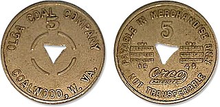
Company scrip is scrip issued by a company to pay its employees. It can only be exchanged in company stores owned by the employers. In the United Kingdom, such truck systems have long been formally outlawed under the Truck Acts. In the United States, payment in scrip became illegal in 1938 as part of the Fair Labor Standards Act.

Kentucky Camp is a ghost town and former mining camp along the Arizona Trail in Pima County, Arizona, United States, near the community of Sonoita. The Kentucky Camp Historic District is listed on the National Register of Historic Places and has been since 1995. As it is located within Coronado National Forest, the United States Forest Service is responsible for the upkeep of the remaining buildings within the Kentucky Camp Historic District.

State Route 116 is a 41.97 miles (67.54 km) long north–south state highway in the mountains of East Tennessee. The highway runs from its junction with SR 62 at its southern end between Wartburg and Coalfield in Morgan County, to its northern end at Caryville, Tennessee in Campbell County.

Whitsett is an unincorporated community in Fayette County, Pennsylvania, United States, approximately 30 miles (50 km) south of Pittsburgh. The population is estimated at 200. It was founded in 1845 by Ralph C. Whitsett Sr. He and his family built a large red brick house in 1873, which still stands today. The community is made up of mostly “company” houses that were built for workers who worked in a large coal mine located nearby; the mine was Banning #21. Most of the houses were ½ houses built to accommodate two families. The mine has been closed since 1954 and most of the houses have been renovated and turned into single-family dwellings.
Stone is an unincorporated community and coal town in Pike County, Kentucky, United States. It was established in 1912. Stone was a mining community named for Galen Stone, head of the Pond Creek Coal Company which was based in Stone. In 1922 the Pond Creek Coal Company was sold to Fordson Coal Company, which was a subsidiary of Ford Motor Company. In 1936 Fordson sold the mine at Stone to Eastern Coal Company.
Royalton is an unincorporated community in Magoffin County, Kentucky, United States. It lies along Route 7 southeast of the city of Salyersville, the county seat of Magoffin County. Its elevation is 879 feet (268 m). Although it is unincorporated it had a post office, with the ZIP code 41464.

Constructed in 1907, the McCreary County Museum is housed in the former Stearns Coal and Lumber Company corporate headquarters in Stearns, Kentucky. The building served as the company's office headquarters in the Southern United States, and maintains the company president's office as an exhibit. The town where the museum is located was called the Stearns Empire of the South, and the museum continues to preserve and display the area's history from the Indian and pioneer times into the town's peak at the height of the coal and lumber industry boom. The exhibits include significant coverage of Appalachian life in McCreary County, including an exhibit on moonshine.
Blue Heron, also known as Mine 18, is a former coal mining community or coal town on the banks of the Big South Fork of the Cumberland River in McCreary County, Kentucky, United States, that has been recreated and is maintained as an interpretive history area in the Big South Fork National River and Recreation Area.

Kentucky Route 92 (KY 92) is a 112.485-mile-long (181.027 km) state highway Kentucky. The route is split into two segments by Lake Cumberland, one of a few state routes in Kentucky with two discontinued segments on both sides of a body of water. The western segment, which is 17.221-mile-long (27.715 km), runs from Kentucky Route 55 west of Joppa to a dead end on Lake Cumberland south of Jamestown via Joppa, Montpelier, Esto, and Jamestown. The eastern segment, which is 95.264-mile-long (153.313 km), runs from a boat ramp on Lake Cumberland northwest of Monticello to U.S. Route 25E west of Fourmile via Monticello, Barrier, Stearns, Carpenter, Timsley, and Ingram.

Ethel is an unincorporated community in Logan County, West Virginia, United States. Ethel is located on West Virginia Route 17, 4.5 miles (7.2 km) east-northeast of Logan. Ethel has a post office with ZIP code 25076.

Packard is a ghost town in Whitley County, Kentucky, United States. Packard was located 7 miles (11 km) southeast of Williamsburg. It was founded as a mining camp by the Thomas B. Mahan family around 1900. Packard's population is thought to have reached at one point nearly 400 residents. The community was a coal town which served the Packard Coal Company; the community and the company were named after Whitley County school teacher Amelia Packard. Packard once had a railway station on the Louisville and Nashville Railroad as well as a post office, which opened on November 27, 1908.
Scuddy is an unincorporated community and coal town in Perry County, Kentucky, United States. Scuddy started mainly as a lumber community, but lumber gave way to coal. After trains entered Perry County in 1912, coal mining surpassed logging. In the 1920s nearby Hazard became the major mining center in the southeastern coalfields. A steadily progressive coal industry continues today. Long before Scuddy became a Coal town, Lumber Baron Ralph Hindo, who also had a hand in founding the town of Ridgway, PA, helped establish a lumber camp in what is now modern day Scuddy. The first such lumber camp was located where the current "Primitive Appalachian Woodwork Home Goods Store" is located but closer to the Carr Fork River. Hindo also, operated a local Haberdashery before closing camp and shop and moving to Ridgway, PA.

Tercio is a ghost town and former coal mine in Las Animas County, in the U.S. state of Colorado. The GNIS classifies it as a populated place. A post office called Tercio was established in 1902, and remained in operation until 1949. The community was the third coal mining community established by the Colorado Fuel and Iron company, hence the name.


