
McCreary County is a county located in the U.S. state of Kentucky. As of the 2020 census, the population was 16,888. Its county seat is Whitley City. The county is named for James B. McCreary, a Confederate war soldier and two-time Governor of Kentucky. During his second term as governor, McCreary County was created by the Legislature and was named in his honor.
Whitley City is an unincorporated community and census-designated place (CDP) in McCreary County, Kentucky, United States. The population was 968 at the 2020 census, down from 1,170 in 2010. It is the county seat of McCreary County. Whitley City is one of two unincorporated county seats in Kentucky.
McCreary County v. American Civil Liberties Union of Kentucky, 545 U.S. 844 (2005), was a case argued before the Supreme Court of the United States on March 2, 2005. At issue was whether the Court should continue to inquire into the purpose behind a religious display and whether evaluation of the government's claim of secular purpose for the religious displays may take evolution into account under an Establishment Clause of the First Amendment analysis.

James Bennett McCreary was an American lawyer and politician from Kentucky. He represented the state in both houses of the U.S. Congress and served as its 27th and 37th governor. Shortly after graduating from law school, he was commissioned as the only major in the 11th Kentucky Cavalry, serving under Confederate Brigadier General John Hunt Morgan during the American Civil War. He returned to his legal practice after the war. In 1869, he was elected to the Kentucky House of Representatives where he served until 1875; he was twice chosen Speaker of the House. At their 1875 nominating convention, state Democrats chose McCreary as their nominee for governor, and he won an easy victory over Republican John Marshall Harlan. With the state still feeling the effects of the Panic of 1873, most of McCreary's actions as governor were aimed at easing the plight of the state's poor farmers.

Somerset Community College (SCC) is a public community college in Somerset, Kentucky. It is part of the Kentucky Community and Technical College System (KCTCS). The college offers academic, general education, and technical curricula leading to certificates, diplomas, and associate's degrees. Somerset Community College is accredited by the Commission on Colleges of the Southern Association of Colleges and Schools (SACS).
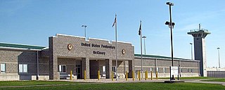
The United States Penitentiary, McCreary is a high-security United States federal prison for male inmates in unincorporated McCreary County, Kentucky. It is operated by the Federal Bureau of Prisons, a division of the United States Department of Justice. The facility also has an adjacent minimum-security satellite camp for male offenders.

Constructed in 1907, the McCreary County Museum is housed in the former Stearns Coal and Lumber Company corporate headquarters in Stearns, Kentucky. The building served as the company's office headquarters in the Southern United States, and maintains the company president's office as an exhibit. The town where the museum is located was called the Stearns Empire of the South, and the museum continues to preserve and display the area's history from the Indian and pioneer times into the town's peak at the height of the coal and lumber industry boom. The exhibits include significant coverage of Appalachian life in McCreary County, including an exhibit on moonshine.

As established and defined by the Kentucky Constitution, the government of the Commonwealth of Kentucky is composed of three branches: the Executive, Judicial, and Legislative.
Blue Heron, also known as Mine 18, is a former coal mining community or coal town on the banks of the Big South Fork of the Cumberland River in McCreary County, Kentucky, United States, that has been recreated and is maintained as an interpretive history area in the Big South Fork National River and Recreation Area.
Strunk is an unincorporated community and coal town in McCreary County, Kentucky, United States. The community's post office was established as Strunks Lane on February 18, 1892, and was probably named for George W. Strunk, who owned a local coal mine. By 1894, the post office's name was simplified to Strunk. Its ZIP code is 42649.
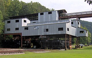
Barthell is a former coal town in McCreary County, Kentucky, United States. It was established in 1902 and was the first of 18 mining camps to be built by the Stearns Coal and Lumber Company. It now serves as an open-air history museum, which is open from April through Thanksgiving.

This is a list of the National Register of Historic Places listings in McCreary County, Kentucky.
Hill Top is an unincorporated community in McCreary County, Kentucky, United States. Hill Top is located on Kentucky Route 92 near the Big South Fork of the Cumberland River, 3.5 miles (5.6 km) west of Whitley City.
Co-Operative is an unincorporated community and coal town in McCreary County, Kentucky, United States. Their post office closed in 1984.
White Oak Junction is an unincorporated community and coal town in McCreary County, Kentucky, United States. Their post office closed in 1949.
Wiborg is an unincorporated community and coal town in McCreary County, Kentucky, United States. Their post office closed in 1988.
Worley is an unincorporated community and coal town in McCreary County, Kentucky, United States. Its post office closed in 1953.
Honeybee is an unincorporated community in McCreary County, Kentucky, United States. Their post office closed in 1983.


