The Unaka Range is a mountain range on the border of Tennessee and North Carolina, in the southeastern United States. It is a subrange of the Appalachian Mountains and is part of the Blue Ridge Mountains physiographic province. The Unakas stretch approximately from the Nolichucky River to the south to the Watauga River to the north. The Unakas include the prominent Roan Highlands, where several summits rise above 6,000 feet. The Iron Mountains border the Unakas to the north, and the Bald Mountains border the Unakas opposite the Nolichucky to the south. The name unaka is rooted in the Cherokee term unega, meaning "white".

Abraham Lincoln Birthplace National Historical Park preserves two separate farm sites in LaRue County, Kentucky where Abraham Lincoln was born and lived early in his childhood. He was born at the Sinking Spring site south of Hodgenville and remained there until the family moved to the Knob Creek Farm northeast of Hodgenville when he was 2 years old, living there until he was 7 years old. The Sinking Spring site is the location of the park visitors center.

Knob Lick is an unincorporated community in southern Saint Francois County, Missouri, United States. It is located on Missouri Route DD just east of U.S. Route 67 about eight miles south of Farmington.
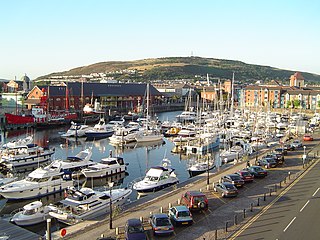
Kilvey Hill is a hill in South Wales, to the east of Swansea. Kilvey Hill is 193 metres (633 ft) high and is classed as a Sub Marilyn. The top of Kilvey Hill enjoys panoramic views of Swansea city centre, Swansea Docks, Swansea Bay, the Lower Swansea Valley, Bon-y-maen, Neath and Port Talbot. Cilfái was a commote of Gower. The historic name of the hill in Welsh is Y Bigwrn, with its summit known as Pen y Bigwrn. Currently, however, it is generally known in Welsh as Mynydd Cilfái, a translation of the English name.

Reddish Knob of Shenandoah Mountain is one of the highest points in Virginia, rising 4,397 feet (1,340 m). A narrow, paved road reaches the summit from Harrisonburg, Virginia.

Dick's Knob or Dicks Knob, with an elevation of 4,620 feet (1,408 m), is the third-highest peak in the State of Georgia if using a 200 ft. prominence rule. It is located in Rabun County, Georgia within the Southern Nantahala Wilderness and is the second-highest mountain in the county.

Rich Knob, elevation 4,152 feet, is located in Towns County, Georgia. It is part of the Georgia portion of the Southern Nantahala Wilderness and is within the boundaries of the Tallulah Ranger District of the Chattahoochee National Forest. The mountain lies along the Appalachian Trail, which crosses over its eastern flank in Rabun County as it enters North Carolina.

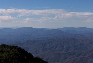
Roan Mountain is the highpoint of the Roan-Unaka Range of the Southern Appalachian Mountains, located in the Southeastern United States. The mountain is clad in a dense stand of Southern Appalachian spruce-fir forest, and includes the world's largest natural rhododendron garden, and the longest stretch of grassy bald in the Appalachian range. The Cherokee National Forest and Pisgah National Forest converge atop the mountain, with Roan Mountain State Park located near its northern base. The Appalachian Trail crosses most of the Roan's crest. The Roan High Knob Shelter is the highest backcountry shelter on the entire 2,174-mile (3,499 km) trail.

Waterrock Knob is a mountain peak in the U.S. state of North Carolina. It is the highest peak in the Plott Balsams and is the 16th-highest mountain in the Eastern United States.

Winterplace Ski Resort is a ski resort located in Ghent, West Virginia on Raleigh County's Flat Top Mountain. The southernmost ski resort in West Virginia, Winterplace is a popular attraction due to its proximity to Interstate 77. It operates in conjunction with The Resort at Glade Springs, a four season golf resort and spa.

Butler Knob is a peak on the Jacks Mountain ridge in south central Pennsylvania in the United States. The "Knobs" summit is underlain with weather resistant quartzite of the Tuscarora Formation. Butler Knob is accessible by a rough road, where there is a closed firetower on the summit. The firetower presently hold a weather station that gives current forecasts for the area.

Mount Chapman is a mountain in the Great Smoky Mountains, located in the Southeastern United States. It has an elevation of 6,417 feet above sea level. While the mountain is located deep within the Great Smokies, the Appalachian Trail crosses its eastern slope, coming to within 200 feet (61 m) of the summit. Mount Chapman is among the 10 highest mountains in the Appalachian range, if subpeaks are not included.

Pilot Knob State Nature Preserve is located in Powell County, Kentucky, USA.

Marks Knob is a mountain in the Great Smoky Mountains, in the southeastern United States. It has an elevation of 6,169 feet (1,880 m), with 249 feet (76 m) of clean prominence. Its summit— located near the center of the Eastern Smokies amidst a dense stand of Southern Appalachian spruce-fir forest— is a popular bushwhacking destination and one of the most difficult-to-reach summits of the Southern Sixers.
Old Butt Knob is a summit in Haywood County, North Carolina, in the United States. It is located within Pisgah National Forest. With an elevation of 5,522 feet (1,683 m), Old Butt Knob is the 114th highest mountain in North Carolina.
Bickett Knob is a summit in Monroe County, West Virginia, in the United States. With an elevation of 3,327 feet (1,014 m), Bickett Knob is the 231st highest summit in the state of West Virginia.
Cottle Knob is a summit in West Virginia, in the United States. With an elevation of 3,031 feet (924 m), Cottle Knob is the 348th highest summit in the state of West Virginia.
Weaver Knob is a summit in West Virginia, in the United States. With an elevation of 2,572 feet (784 m), Weaver Knob is the 833rd highest summit in the state of West Virginia.
Oak Mountain is a summit in the southwestern corner of St. Francois County in the U.S. state of Missouri. The summit has an elevation of 1,631 feet (497 m). The peak is on a north-south trending ridge that extends south into Iron County and the city of Pilot Knob lies just southwest of the mountain. The community of Middlebrook is to the northwest and Iron Mountain Lake is to the north. The source area of Knob Creek is on the west flank of the mountain.


