
Estill County is a county located in the U.S. state of Kentucky. As of the 2010 census, the population was 14,672. Its county seat is Irvine The county was formed in 1808 and named for Captain James Estill, a Kentucky militia officer who was killed in the Battle of Little Mountain during the American Revolutionary War. Estill County is a moist county meaning that the county seat, the city of Irvine, allows the sale of alcohol after the October 9, 2013 vote, but not the rest of Estill County outside the Irvine city limits.

Prestonsburg is a home rule-class city in and the county seat of Floyd County, Kentucky, United States. The population was 3,255 at the time of the 2010 census, down from 3,612 at the 2000 census.

Hazard is a home rule-class city in and the county seat of Perry County, Kentucky, United States. The population was estimated to be 5,346 in 2014.
Black Mountain as a toponym is a common name around the globe. Its variations in other languages include Monte Negro (Latin), Kara Dag (Turkic), Crna Gora (Slavic), Tor Ghar (Persian), and others.

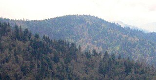
Black Mountain is the highest mountain peak in the Commonwealth of Kentucky, United States, with a summit elevation of 4,145 feet (1,263 m) above mean sea level and a top-to-bottom height of over 2,500 feet (760 m). The summit is located at approximately 36°54′51″N82°53′38″W in Harlan County, Kentucky near the Virginia border, just above the towns of Lynch, Kentucky and Appalachia, Virginia. It is about 500 feet (150 m) taller than any other mountain in Kentucky.

Kentucky County was formed by the Commonwealth of Virginia from the western portion of Fincastle County effective December 31, 1776. During the three and one-half years of Kentucky County's existence, its seat of government was Harrodstown.

Kentucky's 5th congressional district is a congressional district in the U.S. state of Kentucky. Located in the heart of Appalachia in Southeastern Kentucky, the rural district is the second most impoverished district in the nation and, as of the 2010 U.S. Census, it has the highest percentage of White Americans in the nation. Located within the district are the economic leading cities of Pikeville, Prestonburg, Middlesborough, Hazard, Jackson, Morehead, Ashland, London, and Somerset.
Powell Mountain is a mountain ridge of the Ridge-and-valley Appalachians of the Appalachian Mountains. It is a long and narrow ridge, running northeast to southwest, from about Norton, Virginia to near Tazewell, Tennessee. It separates the Clinch River basin and the Powell River basin of Powell Valley. It was named for an 18th-century explorer.
The Battle of Salyersville, also called Battle of Ivy Point Hill, was the largest of the many skirmishes in Magoffin County, Kentucky, during the American Civil War.

Cornettsville is an unincorporated community in Perry County, Kentucky, United States, within the state's eastern mountain region known for coal mining. The population is 792 as of the 2000 United States Census. The town was named for one of the early pioneers to the area, William Jesse Cornett, whose log cabin and burial site can still be seen today.
Mount Sequoyah is a mountain in the Great Smoky Mountains, located in the Southeastern United States. It has an elevation of 6,003 feet above sea level. While the Appalachian Trail crosses its summit, Sequoyah is an 11.5-mile (18.5 km) hike from the nearest parking lot, making it one of the most remote places in the Great Smoky Mountains National Park.
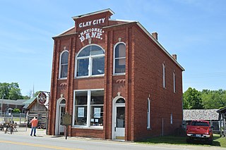
Clay City is a home rule-class city in Powell County, Kentucky, United States. The population was 1,077 at the 2010 census.
Greenwood Mountain is the name of several mountain summits in the United States.

Wesser Bald is a summit located in Macon County, North Carolina, near the community of Wesser. A wooden fire tower at the summit provides hikers with unimpeded views of the Great Smoky Mountains National Park and also the Nantahala Mountains. The Appalachian Trail traverses the summit from roughly north to south with the Nantahala Outdoor Center lying to the north within the Nantahala Gorge and Tellico gap just to the south. Tellico gap has unimproved road access. The climb from Tellico Gap takes an average of 20 minutes. Also, a third route, the blue trail, departs from the end of Wesser Creek Road and follows Wesser Creek up to a point just south of the summit to a fork with the Appalachian Trail. The summit is located at 4,627 ft (1,410 m). and is within Nantahala National Forest. A map detailing the highway routes to access Tellico Gap is available at the Nantahala Outdoor Center. Observable landforms include Wayah Bald, the Nantahala Gorge, and Clingmans Dome among others. The Wesser Fire Tower provides unparalleled 360 degree views of the Smokies in a short 1.5 mile hike from Tellico Gap on the Appalachian Trail, with an elevation gain of about 767 feet. The Fire Tower was originally reported as destroyed during the forest fires which ravaged the Nantahala Forest in November, 2016 but it was later learned that it survived.

Pilot Knob State Nature Preserve is located in Powell County, Kentucky, USA.

Mount Sterling is a mountain in the Great Smoky Mountains of Haywood County, North Carolina, located in the southeastern United States. It reaches an elevation of 5,842 feet (1,781 m) above sea level. The summit is topped by an abandoned fire tower that gives stunning views of other nearby peaks.
The Russell Fork is a 51.9-mile-long (83.5 km) tributary of the Levisa Fork in southwestern Virginia and southeastern Kentucky in the United States. Known for its whitewater, it rises in the Appalachian Mountains of southwest Virginia, in southern Dickenson County, and flows north through the town of Haysi, Virginia, the Breaks Interstate Park, and the town of Elkhorn City, Kentucky, in Pike County, where it flows into the Levisa Fork which, together with the Tug Fork, form the Big Sandy River.
Stuffley Knob is the tallest mountain in Johnson County, Kentucky, with a summit elevation of 1,496 feet above sea level. The summit is located about eight miles west of Paintsville at 37°46′59″N82°55′13″W, just off of U.S. Route 460.
Kentucky Reptile Zoo is a non-profit business in Slade, Kentucky, that specializes in venomous reptiles and the acquisition of venom through a process called venom extraction. The venom is collected for use in medical research programs as well as for the production of anti-serum. The Kentucky Reptile Zoo is owned by Jim Harrison. The zoo has been featured on PBS, Animal Planet and National Geographic Channel.
The Dawkins Line Rail Trail is an 18-mile (29.0 km) rail trail in Johnson and Magoffin Counties in Kentucky. The multi-use trail, suitable for biking, walking, and horseback riding, occupies an abandoned rail corridor that was constructed in the early 20th century for the Dawkins Lumber Company. It is the longest rail trail in Kentucky.


