Related Research Articles

Sullivan County is a county located in the U.S. state of Tennessee on its northeast border. As of the 2020 census, the population was 158,163. Its county seat is Blountville.

Many is a town in, and the parish seat of Sabine Parish in western Louisiana, United States. The population was 2,853 at the 2010 census, a decrease of 36 or 1.246 percent from 2000.

Roan Mountain is a census-designated place (CDP) in Carter County, Tennessee, United States. The population was 1,360 at the 2010 census. It is part of the Johnson City Metropolitan Statistical Area, which is a component of the Johnson City–Kingsport–Bristol, TN-VA Combined Statistical Area – commonly known as the Tri-Cities region.
Blountville is a census-designated place (CDP) in and the county seat of Sullivan County, Tennessee. The population was 3,074 at the 2010 census and 3,120 at the 2020 census. It is the only Tennessee county seat not to be an incorporated city or town.
Colonial Heights is a census-designated place (CDP) in Sullivan County, Tennessee, United States. It is located within the city of Kingsport.

Martin is a city in Weakley County, Tennessee, United States. The population was 10,825 according to the 2020 census. The city is the home of the University of Tennessee at Martin.

Fall Branch is a census-designated place (CDP) in Washington and Greene counties in the U.S. state of Tennessee. The population was 1,291 at the 2010 census. Some areas in Sullivan also use the Fall Branch ZIP code.
Tennessee's 1st congressional district is the congressional district of northeast Tennessee, including all of Carter, Cocke, Greene, Hamblen, Hancock, Hawkins, Johnson, Sullivan, Unicoi, Washington, and Sevier counties and parts of Jefferson County. It is largely coextensive with the Tennessee portion of the Tri-Cities region of northeast Tennessee and southwest Virginia. With a Cook Partisan Voting Index rating of R+30, it is the most Republican district in Tennessee.
Piney Flats is an unincorporated community in Sullivan County in the U.S. state of Tennessee. It is part of the Metropolitan Statistical Area, which is a component of the Johnson City-Kingsport-Bristol, TN-VA Combined Statistical Area – commonly known as the "Tri-Cities" region. Some areas of Piney Flats along U.S. Route 11E have been annexed by Johnson City and Bluff City north of the intersection and areas along Allison Road & Piney Flats Road. The ZIP Code for Piney Flats is 37686.
Boring is an unincorporated community in Sullivan County, Tennessee. Boring is located off Tennessee State Route 75 in Southern Sullivan County, southeast of Kingsport.
Morrison City is an unincorporated community in Sullivan County, Tennessee, United States. Named for pioneer settler Peter Morison, Morrison City developed with the industrial growth of nearby Kingsport, Tennessee, in the 1930s. Peter Morison, his wife Mary Kirkpatrick Morison, and other relatives, are buried in the Morrison Chapel Cemetery, in the heart of the community. They were awarded a land grant by the state of North Carolina, which controlled the area prior to Tennessee Statehood, in 1780. This was to recognize distinguished service during the Battle of King's Mountain.
Flat Gap is an unincorporated community located in Wayne County, Tennessee. The community is just off U.S. Route 64 near the Hardin County line.
Lamar is an unincorporated community in southern Washington County, Tennessee.
South Central is an unincorporated community in southwestern Washington County, Tennessee.
Boones Creek is a neighborhood of Johnson City, in northern Washington County, Tennessee. Almost all of Boones Creek has been annexed by Johnson City, and has become a neighborhood of Johnson City. However, much of it has the postal addresses of "Gray, Tennessee". It extends along Boone's Creek and other nearby tributaries of Boone Lake, from the strip of restaurants, hotels and other businesses around the intersection of Boone's Creek Road and Interstate 26, northeastwards to the older business district at the intersection of 354 and State Route 36, and up to Boone Lake, formerly the Watauga River.
Newmansville is an unincorporated community in northeast Greene County, Tennessee. Newmansville is located at the junction of Tennessee State Routes 93 and 351.
Ottway is an unincorporated community in northern Greene County, Tennessee. It located a few miles off Tennessee State Route 172. It was the location of Ottway Elementary School until its closure in 2019. The school is now North Greene Middle School.
Sulphur Springs is an unincorporated community in north central Washington County, Tennessee. Sulphur Springs is located on Tennessee State Route 75 southwest of Gray and northeast of Limestone.
Tiger Valley is an unincorporated community in Carter County, Tennessee that is located on Tennessee State Route 173 at its junction with U.S. Route 19E. Tiger Valley is located south of Elizabethton, the county seat of Carter County, and north of Roan Mountain.
Holston Valley is an unincorporated community in eastern Sullivan County, Tennessee, United States. Holston Valley is located along U.S. Route 421 and State Route 44 southeast of Bristol.
References
Municipalities and communities of Sullivan County, Tennessee, United States | ||
|---|---|---|
| Cities | 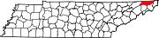 | |
| CDPs | ||
| Other communities | ||
| Footnotes | ‡This populated place also has portions in an adjacent county or counties | |