
Sullivan County is a county located in the U.S. state of Tennessee on its northeast border. As of the 2020 census, the population was 158,163. Its county seat is Blountville.

U.S. Route 79 is a United States highway in the Southern United States. The route is officially considered and labeled as a north-south highway, but its path is actually more of a diagonal northeast-southwest highway. The highway's northern/eastern terminus is in Russellville, Kentucky, at an intersection with U.S. Route 68 and KY 80. Its southern/western terminus is in Round Rock, Texas, at an interchange with Interstate 35, ten miles (16 km) north of Austin. US 79, US 68, and Interstate 24/US 62 are the primary east–west access points for the Land Between the Lakes recreation area straddling the Kentucky/Tennessee border.

U.S. Route 19 or U.S. Highway 19 (US 19) is a north–south United States Numbered Highway in the Eastern United States. Despite encroaching Interstate Highways, the route has remained a long-haul road, connecting the Gulf of Mexico with Lake Erie.

U.S. Route 19E (US 19E) is a divided highway of US 19 in the U.S. states of North Carolina and Tennessee. The United States Numbered Highway, which is complemented by US 19W to the west, travels 75.9 miles (122.1 km) from US 19 and US 19W at Cane River, North Carolina, north to US 11E, US 19, and US 19W in Bluff City, Tennessee. US 19E connects Asheville, North Carolina, and Bristol, Tennessee, with Burnsville, Spruce Pine, and Elk Park in North Carolina and Roan Mountain and Elizabethton in Tennessee. US 19E also has an unsigned concurrency with State Route 37 (SR 37) for its entire course in Tennessee.
U.S. Route 19W (US 19W) traverses approximately 63 miles (101 km) from Cane River, North Carolina, to Bluff City, Tennessee.

U.S. Route 11W (US 11W), locally known as Bloody 11W, is a divided highway of US 11 in the U.S. states of Tennessee and Virginia. The United States Numbered Highway, which is complemented by US 11E to the south and east, runs 110.28 miles (177.48 km) from US 11, US 11E, and US 70 in Knoxville, Tennessee, north and east to US 11, US 11E, US 19, and US 421 in Bristol, Virginia. US 11W connects Knoxville and the twin cities of Bristol, Virginia, and Bristol, Tennessee, with the East Tennessee communities of Rogersville and Kingsport. The U.S. Highway has an unsigned concurrency with State Route 1 (SR 1) for its whole length in Tennessee. In 2021, the route in its entirety was labeled among the top 25 deadliest highways in the U.S.

U.S. Route 11E (US 11E) is a divided highway of US 11 in the U.S. states of Tennessee and Virginia. The United States Numbered Highway, which is complemented by US 11W to the north and west, runs 120.94 miles (194.63 km) from US 11, US 11W, and US 70 in Knoxville, Tennessee, north and east to US 11, US 11W, US 19, and US 421 in Bristol, Virginia. US 11E connects Knoxville and the twin cities of Bristol, Virginia, and Bristol, Tennessee, with the East Tennessee communities of Morristown, Greeneville, and Johnson City. The U.S. Highway runs concurrently with US 70 and US 25W east of Knoxville, US 321 from Greeneville and Johnson City, and both US 19W and US 19 between Johnson City and Bristol. US 11E also has an unsigned concurrency with State Route 34 (SR 34) for almost all of its course in Tennessee.

State Route 44 is a state highway in the U.S. state of Tennessee. It runs from US 11E/US 19W/SR 34 in Bluff City, just south of the split of US 19W and US 19E, northeast via Hickory Tree and Holston Valley to the Virginia state line, where it becomes Virginia State Route 75. The entire highway is located within Sullivan County.

State Route 19 or the Tina Turner Highway is a state highway in Haywood and Lauderdale counties in Tennessee, United States. State Route 19 is 42.81 mi (69 km) long.

State Road 390 is a two-lane state highway in Bay County, Florida. The route is signed as east-west but runs more north-south for much of its run. The western (southern) terminus is at the intersection of U.S. Route 98 (US 98)/SR 30 and US 98 BUS/SR 30A in St. Andrews. The highway is carried by Beck Ave from this point until shortly after it crosses SR 368, at which point it becomes St Andrews Blvd. The route winds northeasterly into Lynn Haven, where it is carried by Tennessee Ave at one point. In Lynn Haven, the road eventually turns due east and intersects with SR 77, and continues east until its terminus at US 231/SR 75. The portion between SR 77 and US 231 was signed as SR S-390 before being given to the county in the late 1970s, and back to the state in 2016.

U.S. Route 19 (US 19) traverses approximately 11.8 miles (19.0 km) across the Tri-Cities area of East Tennessee. The highway begins at Bluff City, where the highway splits into US 19E and US 19W, which both head into North Carolina and rejoin to form US 19 in North Carolina. US 19's Tennessee portion ends at the Virginia state line at the twin cities of Bristol, Tennessee, and Bristol, Virginia.

U.S. Route 421 is a north–south United States highway that runs for 43.4 miles (69.8 km) in East Tennessee, connecting the cities of Mountain City and Bristol.

State Route 59 is a state highway in Tennessee. It runs from the Mississippi River to just north of Somerville passing through Tipton and Fayette counties. Excluding the portion where it is concurrent with US 51 in Covington, which is 4-lane highway, it is a two-lane rural highway throughout its length and carries a 55 miles per hour (89 km/h) speed limit except when it passes through towns, in which case this speed limit can be significantly less.
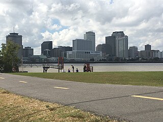
The Mississippi River Trail is a designated bicycle and pedestrian trail that traverses the shores of the Mississippi River in the United States. The trail extends from the headwaters at Lake Itasca in Minnesota to near the mouth of the river in Venice, Louisiana. Much of the trail’s 3,000 miles (4,800 km) follows roadways used by motor vehicles, although some of the route is on multi-use trails. The segment in Minnesota has been designated as U.S. Bicycle Route 45, part of the U.S. Bicycle Route System.
State Route 36 (SR 36) is a 28.6-mile-long (46.0 km) state highway, broken in two segments. In Unicoi County, it serves as the hidden concurrency of U.S. Route 19W; in Washington and Sullivan counties, it serves as a stand-alone secondary road connecting the cities of Johnson City and Kingsport.
State Route 394 is a west-east state highway in Sullivan County, Tennessee. It serves as southern bypass of Bristol and as a connector route from Interstate 81 (I-81) to Bristol Motor Speedway. The western terminus is at an intersection with U.S. Route 11W northwest of Blountville and the eastern terminus is at a junction with US 421 southeast of Bristol. The route heads southeast and crosses I-81 before passing through Blountville. From here, SR 394 continues southeast to an interchange with US 11E/US 19 near Bristol Motor Speedway, where it turns northeast and continues to US 421.

State Route 126 is a 24.6-mile-long (39.6 km) state highway that travels through Sullivan County in East Tennessee. It connects Kingsport and Bristol.

State Route 346 is a 24.3-mile-long (39.1 km) state highway in Hawkins and Sullivan counties in the eastern part of the U.S. state of Tennessee. It connects Surgoinsville with Kingsport.

State Route 358 is a state highway in Sullivan County in the Tri-Cites region of East Tennessee.

State Route 34 is a state highway located in East Tennessee. The 155.7-mile-long (250.6 km) route traverses several cities through eight counties from the Knoxville area to the North Carolina state line via Greeneville and Bristol. The portion from Carter to Bristol is concurrent with U.S. Route 11E (US 11E) while the portion from Bristol to North Carolina is concurrent with US 421.


