Long Hunter State Park

Last updated
Long Hunter State Park
Percy-priest-lake-tn1.jpg
J. Percy Priest Lake
Long Hunter State Park
TypeTennessee State Park
Location Hermitage, Hermitage, Tennessee
Coordinates 36°05′33″N86°33′20″W / 36.0924°N 86.5555°W / 36.0924; -86.5555 Coordinates: 36°05′33″N86°33′20″W / 36.0924°N 86.5555°W / 36.0924; -86.5555
Operated by TDEC
Website Long Hunter State Park

Long Hunter State Park is a state park in Davidson County and Rutherford County, Tennessee, located in the southeastern United States. The park is mostly situated along the eastern shores of Percy Priest Lake, an artificial lake created by an impoundment of the Stones River.

Contents

Long Hunter State Park comprises three lake sections — Baker's Grove in the north, Couchville at the center, and Bryant Grove to the south. All three sections are connected by narrow strips of land. The park also manages Sellars Farm, a state archaeological area near Lebanon to the east.

Geographical setting

The shore of J. Percy Priest Lake near Bakers Grove, before the morning fog has lifted Stones-river-tn1.jpg
The shore of J. Percy Priest Lake near Bakers Grove, before the morning fog has lifted

The West Fork of Stones River flows northward from its source in the hills around Rock Springs, passes through Murfreesboro and Stones River National Battlefield, and merges with the East Fork of Stones River near Smyrna. The East Fork flows westward from its source atop Short Mountain, at the edge of the Highland Rim, and passes north of Murfreesboro. The confluence of these two rivers forms Stones River proper, and marks the southern extreme of J. Percy Priest Lake.

Stones River's J. Percy Priest Lake impoundment stretches for approximately 22 miles (35 km) between the confluence of the West Fork and East Fork to the south and the J. Percy Priest Dam near Donelson to the north. Downstream from the dam, Stones River winds its way through a series of bends toward its mouth along the Cumberland River, just east of Nashville. Long Hunter State Park is officially located in Hermitage, a suburb of Nashville.

Tennessee State Route 171 follows Mount Juliet Road south from Interstate 40 to the park's boundary. The two roads then split, with TN-171 continuing west along Hobson Pike to the park's Couchville section, and Mount Juliet Road (now South Mount Juliet Road) continuing south to the park's Bryant Grove section. Granny Wright Road, which intersects TN-171 just north of its split with Mount Juliet Road, accesses the Volunteer Trailhead and the park's Bakers Grove section.

An old stone property wall near the end of the Volunteer Trail Long-hunter-state-park-wall-tn1.jpg
An old stone property wall near the end of the Volunteer Trail

History

Native Americans were hunting in the Stones River Basin as early as 12,000 years ago, as evidenced by flint tools found on the grounds of Long Hunter State Park. [1] The Nashville Basin is full of evidence of Paleo-Indian habitation, including Clovis points and a mastodon kill site in Williamson County, several miles west of Stones River on the other side of Nashville. A fortified Mississippian-era village was located near Lebanon at Sellars Farm, the site of which is now maintained by Long Hunter State Park. The Sellars Farm site was occupied between A.D. 1000–1300, and included a series of "platform" mounds and a central plaza. [2]

Among the first Euro-Americans to explore the Nashville Basin were small groups of hunters known as long hunters. Long hunters had arrived in the region by the 1760s, typically following the Cumberland River valley from Virginia. The term "long hunter" referred to the relatively lengthy period of time (usually 6–18 months) a typical long hunt lasted. Most long hunters initially sought animal furs for sale back in Virginia, although later long hunters were employed as surveyors. Stones River, upon which Long Hunter State Park is situated, is named for Uriah Stone, a long hunter who allegedly had all of his furs stolen by a French companion while hunting along the river in 1767. [3] Geographical and topographical information gathered by long hunters would later be invaluable to the Nashville area's first settlers. [4]

Campsite 2, the end of the Volunteer Trail Volunteer-trail-long-hunter-tn1.jpg
Campsite 2, the end of the Volunteer Trail

After the Cherokee ceded the Stones River area to the United States in 1805, settlers began to arrive in large numbers. Among the first to settle at what is now Long Hunter State Park were Sherrod Bryant and his son, Henderson, who were living in the valley by 1820. The Bryants, who were the namesake for Bryant Grove, were one of the wealthiest African American families in the state by the time of Sherrod's death in 1854. Other early settlers included the Couch family, who operated a store and river crossing just north of Bryant Grove. [1]

In 1963, largely due to the demand for flood control along the volatile Stones River, the United States Army Corps of Engineers began construction on Stewart's Ferry Dam near Donelson. The dam — which was renamed for Congressman James Percy Priest (1900–1956) — was completed in 1968. The impoundment of the river forced water to back up through underground channels, leading to the formation of Couchville Lake, the small lake situated near the center of the park. In 1972, the Corps of Engineers leased 2,400 acres (9.7 km2) of land on the east shore of the reservoir to the state of Tennessee for the formation of a state park. Long Hunter State Park officially opened in 1978. [1]

The Sellars Mound site, which had been excavated by Peabody Museum curator Frederic Putnam in the late 1870s, was added to the National Register of Historic Places in 1972 and purchased by the state of Tennessee in 1974. In the late 1990s, the Friends of Sellars Farm State Archaeological Area was formed by volunteers who began promoting the site and offering tours. The site became a satellite of Long Hunter State Park in 2004. [2]

Couchville Lake Couchville-lake-tn1.jpg
Couchville Lake

The park today

Long Hunter State Park consists of approximately 2,600 acres (11 km2) managed by the Tennessee Department of Environment and Conservation. The park includes two boat launch ramps on J. Percy Priest Lake, several miles of hiking trails, several group campsites and one backcountry campsite, a meeting facility, and a visitor center. Non-motorized boats are allowed on Couchville Lake.

The 5.5-mile (8.9 km) Volunteer Trail follows the lakeshore, connecting the Couchville and Bakers Grove sections. Two back country campsites are located at the end of the trail. A flat, paved trail circles Couchville Lake (which is not connected by surface water to Percy Priest Lake), and includes a 300-foot (91 m) bridge spanning the eastern end of the lake. The Jones Mill Trail, in the Bryant Grove section, leads to the top of Bald Knob, a clear hilltop that overlooks J. Percy Priest Lake.

Related Research Articles

Petit Jean State Park United States historic place

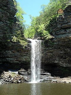
Petit Jean State Park is a 3,471-acre (1,405 ha) park in Conway County, Arkansas managed by the Arkansas Department of Parks and Tourism. It is located atop Petit Jean Mountain adjacent to the Arkansas River in the area between the Ouachita Mountains and Ozark Plateaus.

Cumberland River River in Kentucky and Tennessee, United States

The Cumberland River is a major waterway of the Southern United States. The 688-mile-long (1,107 km) river drains almost 18,000 square miles (47,000 km2) of southern Kentucky and north-central Tennessee. The river flows generally west from a source in the Appalachian Mountains to its confluence with the Ohio River near Paducah, Kentucky, and the mouth of the Tennessee River. Major tributaries include the Obey, Caney Fork, Stones, and Red rivers.

French Broad River River in North Carolina and Tennessee, United States

The French Broad River is a river in the U.S. states of North Carolina and Tennessee. It flows 218 miles (351 km) from near the town of Rosman in Transylvania County, North Carolina, into Tennessee, where its confluence with the Holston River at Knoxville forms the beginning of the Tennessee River. The river flows through the counties of Transylvania, Buncombe, Henderson, and Madison in North Carolina, and Cocke, Jefferson, Sevier, and Knox in Tennessee. It drains large portions of the Pisgah National Forest and the Cherokee National Forest.

Holston River River in Tennessee, United States

The Holston River is a 136-mile (219 km) river that flows from Kingsport, Tennessee, to Knoxville, Tennessee. Along with its three major forks, it comprises a major river system that drains much of northeastern Tennessee, southwestern Virginia, and northwestern North Carolina. The Holston's confluence with the French Broad River at Knoxville marks the beginning of the Tennessee River.

Stones River River in the United States

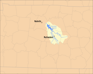
The Stones River is a major stream of the eastern portion of Tennessee's Nashville Basin region. It is named after explorer and longhunter Uriah Stone, who navigated the river in 1767.

Caney Fork River River in Tennessee, United States

The Caney Fork River is a river that flows through central Tennessee in the United States, draining a substantial portion of the southwestern Cumberland Plateau and southeastern Highland Rim regions. It is a major tributary of the Cumberland River, and is part of the Cumberland, Ohio and Mississippi basins. The river is 143 miles (230 km) long, and its watershed covers 1,771 square miles (4,590 km2) in eleven counties. Monterey, Baxter, Sparta, Smithville, McMinnville, Altamont, Spencer and Gordonsville are among the towns that are at least partially drained by the river.

Port Royal State Historic Park is a 26 acre historic area on the border of Montgomery and Robertson. The community of Port Royal is the namesake of the site. Port Royal existed as a town from 1797 to 1940, when the post office officially closed. The Red River runs through the center of the park. The park was established to preserve the former town and the elements of early Tennessee history, the history of the Red River Valley, as well as the heritage of the Trail of Tears and the Black Patch Tobacco Wars.

Curecanti National Recreation Area

Curecanti National Recreation Area(Pronounced or .) is a National Park Service unit located on the Gunnison River in western Colorado. Established in 1965, Curecanti National Recreation Area is responsible for developing and managing recreational facilities on three reservoirs, Blue Mesa Reservoir, Morrow Point Reservoir and Crystal Reservoir, constructed on the upper Gunnison River in the 1960s by the U.S. Bureau of Reclamation to better utilize the vital waters of the Colorado River and its major tributaries. A popular destination for boating and fishing, Curecanti offers visitors two marinas, traditional and group campgrounds, hiking trails, boat launches, and boat-in campsites. The state's premiere lake trout and Kokanee salmon fisheries, Curecanti is a popular destination for boating and fishing, and is also a popular area for ice-fishing in the winter months.

Rock Island State Park (Tennessee) Park in Warren and White Counties, Tennessee, United States

Rock Island State Park is a state park in Warren County and White County, Tennessee, located in the Southeastern United States. The park is named after the community of Rock Island, Tennessee, which in turn received its name from an island on the Caney Fork upstream from the Collins River confluence and Great Falls Dam. Rock Island State Park is centered on a peninsula created by the confluence of these two rivers and extends downstream to the headwaters of Center Hill Lake.

Edgar Evins State Park State park in Tennessee, United States

Edgar Evins State Park is a state park in DeKalb County, Tennessee, in the southeastern United States. The park consists of 6,300 acres (25 km2) along the shores of Center Hill Lake, an impoundment of the Caney Fork. The State of Tennessee leases the land from the U.S. Army Corps of Engineers.

Tennessee State Route 171

State Route 171 runs south–north through Davidson and Wilson counties in the state of Tennessee. It connects Interstate 24 to U.S. Route 70.

Percy Priest Lake Body of water

J. Percy Priest Lake is a reservoir in north central part of Tennessee. It is formed by J. Percy Priest Dam, located between miles six and seven of the Stones River. The dam is located about 10 miles (16 km) east of downtown Nashville and impounds a lake 42 mi (68 km) long. The lake and dam are named for Congressman Percy Priest.

Great Falls Dam (Tennessee) United States historic place

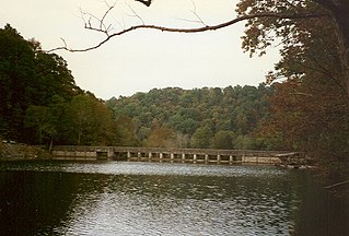
Great Falls Dam is a hydroelectric dam on the Caney Fork, straddling the county line between White County and Warren County in the U.S. state of Tennessee. It is the only dam outside the Tennessee River watershed owned and operated by the Tennessee Valley Authority. The dam impounds the 1,830-acre (740 ha) Great Falls Lake, and its tailwaters feed into Center Hill Lake. The completion of Great Falls Dam in late 1916 was an engineering triumph, marking the first successful attempt to impound the volatile and flood-prone Caney Fork. The dam is also notable for its design, utilizing a mostly underground conduit to carry water from the reservoir via a tributary to the Power House 0.75 miles (1.21 km) downstream from the dam.

Standing Stone State Park State Park in Overton County, Tennessee, United States of America

Standing Stone State Park is a state park in Overton County, Tennessee, in the southeastern United States. The park consists of 855 acres (3.46 km2) along the shoreline of the man-made 69-acre (0.28 km2) Standing Stone Lake. The 11,000-acre (45 km2) Standing Stone State Forest surrounds the park.

Norris Dam State Park United States historic place

Norris Dam State Park is a state park in Anderson County and Campbell County, Tennessee, in the southeastern United States. The park is situated along the shores of Norris Lake, an impoundment of the Clinch River created by the completion of Norris Dam in 1936. The park consists of 4,038 acres (16.34 km2) managed by the Tennessee Department of Environment and Conservation. The park also administers the Lenoir Museum Complex, which interprets the area's aboriginal, pioneer, and early 20th-century history.

Big Ridge State Park State park in Tennessee, United States

Big Ridge State Park is a state park in Union County, Tennessee, in the southeastern United States. The park consists of 3,687 acres (14.92 km2) on the southern shore of the Norris Reservoir, an impoundment of the Clinch River created by the completion of Norris Dam in 1936. Much of the park's recreational focus is on Big Ridge Lake, a 45-acre (0.18 km2) sub-impoundment of Norris near the center of the park.

Cove Lake State Park State park in Tennessee, United States

Cove Lake State Park is a state park in Campbell County, Tennessee, in the southeastern United States. The park consists of 673 acres (2.72 km2) situated around Cove Lake, an impoundment of Cove Creek created by the completion of Caryville Dam in 1936. The park's location is adjacent to the town of Caryville and just west of Jacksboro.

Bledsoe Creek State Park State-protected area of Tennessee, United States

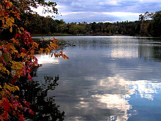
Bledsoe Creek State Park is a state park in Sumner County, Tennessee, in the southeastern United States. The park consists of 169 acres (0.68 km2) managed by the Tennessee Department of Environment and Conservation. The park spans much of the west shore of the Bledsoe Creek embayment of Old Hickory Lake, an impoundment of the Cumberland River created with the completion of Old Hickory Dam by the U.S. Army Corps of Engineers in 1954.

Sellars Farm site

Sellars Farm site (40WI1), also known as the Sellars Farm state archaeological area and Sellars Indian mound, is a Mississippian culture archaeological site located in Wilson County, Tennessee, near Lebanon. The platform mound was the site of a settlement from about 1000 to 1300 CE. Today, the site is a satellite unit of Long Hunter State Park. The non-profit Friends of the Sellars Farm State Archaeological Area organization conducts tours and upkeep of the site. It was listed on the National Register of Historic Places on December 11, 1972.

References

  1. 1 2 3 Froeschauer, John. "A Look At Long Hunter's History". The Tennessee Conservationist. Retrieved 2008-01-15.
  2. 1 2 Roebuck, Lynn (2006). "Friends of the Sellars Farm State Archaeological Area". Webwhispher.com. Archived from the original on 2008-03-11. Retrieved 2008-01-15.
  3. "Long Hunter State Park History" (PDF). Tennessee Department of Environment and Conservation. Retrieved 2008-01-15.
  4. Ramsey, J G M (1999). Annals of Tennessee. Johnson City: Overmountain Press. pp. 65–69, 94–97. ISBN   1-57072-091-6. OCLC   42464976.