Justin P. Wilson Cumberland Trail State Park

Last updated
Justin P. Wilson Cumberland Trail State Park
Cumberland trail sign.jpg
A typical trail sign on the New River segment
TypeTennessee State Park
Location Caryville, Tennessee
Coordinates 36°18′42″N84°12′49″W / 36.3116°N 84.2135°W / 36.3116; -84.2135
Operated by TDEC
Website Justin P. Wilson Cumberland Trail State Park

The Justin P. Wilson Cumberland Trail State Park, commonly known as the Cumberland Trail, is a Tennessee hiking trail following a line of ridges and gorges along the eastern escarpment of the Cumberland Plateau and Cumberland Mountains in Tennessee. The trail begins at Cumberland Gap National Historical Park and ends at Chickamauga and Chattanooga National Military Park and Prentice Cooper Wildlife Management Area just outside Chattanooga, Tennessee. The trail travels through 11 Tennessee counties and two time zones.

Contents

History

The Cumberland Trail became Tennessee's 53rd state park in 1998 and the state's only linear park. The park is named for Justin P. Wilson in honor of his work to help make the vision of the Cumberland Trail a reality. Wilson served as the commissioner of the Tennessee Department of Environment and Conservation in 1996 and deputy governor for policy for former Tennessee Governor Don Sundquist. As of 2014 he is Comptroller of the State of Tennessee, an attorney, longtime Republican Party and conservation activist who donated a considerable portion of the land involved.

The Trail

When completed, the Justin P. Wilson Cumberland Trail State Park is to contain a core corridor of trail stretching from Cumberland Gap National Historical Park to the Chickamauga and Chattanooga National Military Park and Prentice Cooper Wildlife Management Area.

The Cumberland Trail is designed for hikers by hikers as a sustainable single file back country hiking trail, part of the Great Eastern Trail, through more remote areas of the Appalachian Mountains. An alternative to the relatively crowded Appalachian Trail. it gives hikers access to areas preserved for their natural or scenic beauty that cannot be otherwise accessed, providing a wilderness experience rare in the eastern US. The rugged trail follows numerous sparsely populated ridge lines where the trail designers have strategically routed the trail to spectacular overlooks and scarce drinking water sources. The trail dips into gorges where hikers can find waterfalls and swimming holes. It is designed and built to minimize the potential environmental impact on sensitive wildlife habitat, unique aquatic or terrestrial habitats, or endangered and threatened species.

Route

Still a work-in-progress, as of November 2016, 210 mi (340 km) of trail are ready for hiking and over 300 mi (483 km) of trails are planned. Segments include: the Cumberland Mountain segment above La Follette and Jacksboro and in the Cumberland Gap National Historic Park; the Smoky Mountain segment in Campbell County; the Frozen Head segment in Morgan County; the Obed Wild and Scenic River segment in the Obed Wild and Scenic River and Catoosa Wildlife Management Area; the Grassy Cove segment on Black and Brady mountains in Cumberland County; the Rock Creek, Possum Creek, Soddy Creek, and North Chickamauga segments in Hamilton County; and the Tennessee River Gorge segment in Prentice Cooper State Forest.

Management

Cumberland Trail State Park offices are located in Caryville, Pikeville, and Signal Mountain. Volunteers from all over the US and several volunteer hiking organizations are also working under direction of the Tennessee State Parks in building new sections of the trail.

A number of private organizations support the Cumberland Trail financially and with volunteer efforts. The list of supporters is long. Wild Trails, the Chattanooga nonprofit that directs money to building and maintaining wilderness path projects through the region; Break Away: the Alternative Break Connection; Lyndhurst Foundation; Anne Potter Wilson Foundation; the Cumberland Trails Conference (CTC); and the Friends of the Cumberland Trail are most active in the private sector funding, trail development, and on-the-ground construction of the Cumberland Trail. A number of other individuals and volunteer organizations are also assisting in bringing the vision of the Cumberland Trail closer to completion.

Tennessee State Parks and the Tennessee Trails Association sponsor volunteer trail building programs several times a year to build new sections of trail. The biggest of these programs is the BreakAway program. BreakAway program is an Alternative Spring Break (ASB) program managed by the Cumberland Trails Conference that allows college students to engage in volunteer services such as trail building during their spring and fall college breaks. A big portion of the 235,000 hours donated to date to construct and maintain the trail have been BreakAway students.

Head of Sequatchie

The head of the Sequatchie River is located in the park near Pikeville. The park's main office and visitor center are also located at the Head of Sequatchie. [1]

See also

Related Research Articles

<span class="mw-page-title-main">Sequatchie County, Tennessee</span> County in Tennessee, United States

Sequatchie County is a county located in the U.S. state of Tennessee. As of the 2020 census, the population was 15,826. Its county seat is Dunlap. Sequatchie County is part of the Chattanooga, TN–GA Metropolitan Statistical Area.

<span class="mw-page-title-main">Marion County, Tennessee</span> County in Tennessee, United States

<span class="mw-page-title-main">Cumberland County, Tennessee</span> County in Tennessee, United States

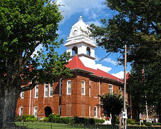
Cumberland County is a county located in the U.S. state of Tennessee. As of the 2020 census, the population was 61,145. Its county seat is Crossville. Cumberland County comprises the Crossville, TN micropolitan statistical area.

<span class="mw-page-title-main">Dunlap, Tennessee</span> City in Tennessee, United States

Dunlap is a city in and the county seat of Sequatchie County, Tennessee, United States. The population was 5,357 at the 2020 census and 4,815 at the 2010 census.

<span class="mw-page-title-main">East Tennessee</span> Geographic and cultural region of Tennessee, United States

East Tennessee is one of the three Grand Divisions of Tennessee defined in state law. Geographically and socioculturally distinct, it comprises approximately the eastern third of the U.S. state of Tennessee. East Tennessee consists of 33 counties, 30 located within the Eastern Time Zone and three counties in the Central Time Zone, namely Bledsoe, Cumberland, and Marion. East Tennessee is entirely located within the Appalachian Mountains, although the landforms range from densely forested 6,000-foot (1,800 m) mountains to broad river valleys. The region contains the major cities of Knoxville and Chattanooga, Tennessee's third and fourth largest cities, respectively, and the Tri-Cities, the state's sixth largest population center.

<span class="mw-page-title-main">Lookout Mountain</span> Mountain in northwestern Georgia, United States

Lookout Mountain is a mountain ridge located at the northwest corner of the U.S. state of Georgia, the northeast corner of Alabama, and along the southeastern Tennessee state line in Chattanooga. Lookout Mountain was the scene of the 18th-century "Last Battle of the Cherokees" in this area during the Nickajack Expedition. On November 24, 1863, during the American Civil War, the Battle of Lookout Mountain took place here.

<span class="mw-page-title-main">Sequatchie River</span> River in Tennessee, United States

The Sequatchie River is a 116-mile-long (187 km) waterway that drains the Sequatchie Valley, a large valley in the Cumberland Plateau in Tennessee. It empties into the Tennessee River downstream from Chattanooga near the Tennessee-Alabama state line.

<span class="mw-page-title-main">Cloudland Canyon State Park</span> State park in Georgia, United States

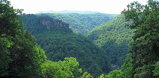
Cloudland Canyon State Park is a 3,485 acres (14.10 km2) Georgia state park located near Trenton and Cooper Heights on the western edge of Lookout Mountain. One of the largest and most scenic parks in Georgia, it contains rugged geology, and offers visitors a range of vistas across the deep gorge cut through the mountain by Sitton Gulch Creek, where the elevation varies from 800 to over 1,800 feet. Views of the canyon can be seen from the picnic area parking lot, in addition to additional views located along the rim trail. At the bottom of the gorge, two waterfalls cascade across layers of sandstone and shale, ending in small pools below.

<span class="mw-page-title-main">Chickamauga Creek</span> Tributary of the Tennessee River in the United States of America

North and South Chickamauga Creek are short tributaries of the Tennessee River which join it near Chattanooga, Tennessee on the north and the south. West Chickamauga Creek is a much longer tributary of South Chickamauga Creek.

<span class="mw-page-title-main">Cumberland Mountain State Park</span> State park in Tennessee, United States

Cumberland Mountain State Park is a state park in Cumberland County, Tennessee, in the southeastern United States. The park consists of 1,720 acres (7.0 km2) situated around Byrd Lake, a man-made lake created by the impoundment of Byrd Creek in the 1930s. The park is set amidst an environmental microcosm of the Cumberland Plateau and provides numerous recreational activities, including an 18-hole Bear Trace golf course.

<span class="mw-page-title-main">Frozen Head State Park</span> State park in Tennessee, United States

Frozen Head State Park and Natural Area is a state park in Morgan County, Tennessee, in the southeastern United States. The park, situated in the Crab Orchard Mountains between the city of Wartburg and the community of Petros, contains some of the highest mountains in Tennessee west of the Blue Ridge.

<span class="mw-page-title-main">Cove Lake State Park</span> State park in Tennessee, United States

Cove Lake State Park is a state park in Campbell County, Tennessee, in the southeastern United States. The park consists of 673 acres (2.72 km2) situated around Cove Lake, an impoundment of Cove Creek created by the completion of Caryville Dam in 1936. The park's location is in the town of Caryville and west of Jacksboro.

<span class="mw-page-title-main">Pocket wilderness</span> Type of nature reserve in Tennessee

Pocket wilderness is a name used by Bowater corporation and the State of Tennessee for any of several tracts of Bowater-owned private land on and near the Cumberland Plateau that the company set aside beginning in 1970 "for preservation in its natural state, with no logging or development other than hiking trails permitted within its boundaries" and registered as Tennessee state natural areas. Several areas formerly managed as Bowater pocket wilderness are now incorporated into state-owned natural areas or National Park Service sites.

<span class="mw-page-title-main">U.S. Route 64 in Tennessee</span>

In Tennessee, U.S. Route 64 stretches 404.1 miles (650.3 km) from the Mississippi River in Memphis to the North Carolina state line near Ducktown. The highway, along with US 72, is a major route for travel between Memphis and Chattanooga.

<span class="mw-page-title-main">U.S. Route 127 in Tennessee</span> Highway in Tennessee, United States

U.S. Route 127 in Tennessee is a 129.5-mile-long (208.4 km) United States Numbered Highway from Chattanooga to the Kentucky state line at Static. The highways connects through Dunlap, Pikeville, Crossville, and Jamestown. Throughout its length, US 127 straddles the line between East Tennessee and Middle Tennessee.

<span class="mw-page-title-main">Tennessee State Route 28</span> State highway in Tennessee, United States

State Route 28 is a state highway in the state of Tennessee, traversing the state in a north–south axis from south of Jasper to the Kentucky state line at Static.

<span class="mw-page-title-main">Tennessee State Route 30</span> Highway in Tennessee, United States

State Route 30 is an east-west state highway in the central and eastern portions of the U.S. state of Tennessee. It runs generally west to east, connecting McMinnville in Warren County with Parksville along the Ocoee River in Polk County. It crosses several major geographic features in Tennessee, including the Cumberland Plateau, the Sequatchie Valley, the Tennessee River, and parts of the Cherokee National Forest.

<span class="mw-page-title-main">Little Laurel Branch</span> Protected natural area in Virginia, United States

Little Laurel Branch, a wildland in the George Washington and Jefferson National Forests of western Virginia, has been recognized by the Wilderness Society as a special place worthy of protection from logging and road construction. The Wilderness Society has designated the area as a "Mountain Treasure".

References