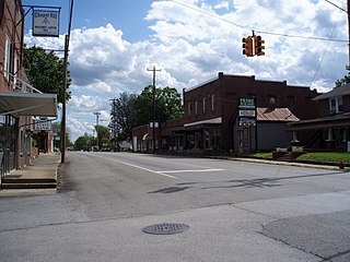
Chapel Hill is a town in northeastern Marshall County, Tennessee, United States. The town was named after Chapel Hill, North Carolina, by settlers from that area. The population was 1,717 as of the 2020 census.

Allegany State Park is a state park in western New York State, located in Cattaraugus County just north of the Allegheny National Forest in Pennsylvania. The park is divided into two sections: The Red House Area and the Quaker Run Area. It lies within the Allegheny Highlands forests ecoregion.
Verona Beach State Park is a 1,735-acre (7.02 km2) state park located on the eastern shore of Oneida Lake in the Town of Verona, Oneida County, New York. The park is located on NY 13 northwest of the City of Oneida and south of Sylvan Beach. Oneida Creek enters the Oneida Lake south of the park.
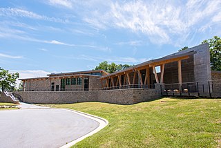
Gorges State Park is a 7,709-acre (31.20 km2) North Carolina state park in Transylvania County, North Carolina in the United States and along with other conservation lands is part of a 100,000+ acre conservation corridor stretching some 80 miles along the NC/SC state line. The land, along Jocassee Gorges, was purchased by the state from Duke Energy Corporation in 1999. It is North Carolina's westernmost state park and one of the state's newest. The park is adjacent to part of the Pisgah National Forest and the N.C. Wildlife Resources Commission's Toxaway Game Land. Gorges State Park provides the principal access to the Horsepasture River on these adjoining public lands.
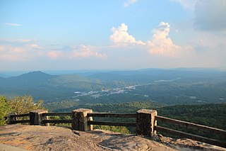
Black Rock Mountain State Park is a 1,743-acre (705 ha) Georgia, United States, state park west of Mountain City in Rabun County, in the Blue Ridge Mountains. It is named after its sheer cliffs of dark-colored biotite gneiss. Astride the Eastern Continental Divide at an elevation of 3,640 feet (1,110 m), the park provides many scenic overlooks and 80-mile (130 km) vistas of the southern Appalachian Mountains. On a clear day, four states are visible: Georgia, North Carolina, South Carolina, and Tennessee. In addition to Black Rock Mountain itself, the park includes four other peaks over 3,000 feet (910 m) in elevation, making it the state's highest state park. As of 2019, it was open to visitors year round.

F.D. Roosevelt State Park is a 9,049 acres (36.62 km2) Georgia state park located near Pine Mountain and Warm Springs. The park is named for former U.S. President Franklin Delano Roosevelt, who sought a treatment for his paralytic illness in nearby Warm Springs at the Little White House. The park is located along the Pine Mountain Range. The western portion of the park, formerly named Pine Mountain State Park, was named a National Historic Landmark in 1997. F.D. Roosevelt State Park is Georgia's largest state park.

Edgar Evins State Park is a state park in DeKalb County, Tennessee, in the southeastern United States. The park consists of 6,300 acres (25 km2) along the shores of Center Hill Lake, an impoundment of the Caney Fork. The State of Tennessee leases the land from the U.S. Army Corps of Engineers.

P. H. Hoeft State Park is a public recreation area on the shores of Lake Huron, four miles (6.4 km) northwest of Rogers City on US 23 in Presque Isle County, Michigan. The park was added to the National Register of Historic Places in 2009.

Onaway State Park is a public recreation area covering 158 acres (64 ha) on the southeast shore of Black Lake in North Allis Township, Presque Isle County, Michigan. The state parks sits at the end of M-211 five miles north of Onaway. It contains sand and cobblestone beaches, large rock outcroppings, a campground, and nature trail highlighting a diversity of trees. The park was added to the National Register of Historic Places in 2009.

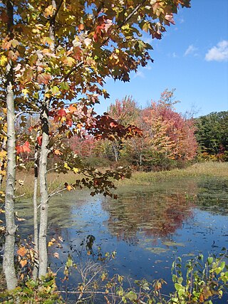
Wilgus State Park is a state park in Ascutney, Vermont. The park offers canoeing along the Connecticut River and hiking up the Pinnacle Trail. The park has tent and lean-to sites and is quite close to Mount Ascutney and the Saint-Gaudens National Historic Site. The park was originally constructed by the Civilian Conservation Corps (CCC) and is now administered by the Vermont Department of Forests, Parks, and Recreation as part of the Vermont state park system. It is named after William J. Wilgus, who donated the land for the park in 1933. The park is listed on the National Register of Historic Places for its well-preserved CCC infrastructure.

Keystone State Park is a 1,200-acre (486 ha) Pennsylvania state park in Derry Township, Westmoreland County, Pennsylvania in the United States. Located off U.S. Route 22 near New Alexandria, the park opened in 1945. Its main attraction is the man-made 78-acre (32 ha) Keystone Lake. The park also has extensive picnic areas and several miles of hiking trails.

Bald Eagle State Park is a 5,900-acre (2,388 ha) Pennsylvania state park in Howard, Liberty, and Marion townships in Centre County, Pennsylvania in the United States. The park includes the Foster Joseph Sayers Reservoir, formed by damming Bald Eagle Creek and other smaller streams and covering 1,730 acres (700 ha). Bald Eagle State Park is at the meeting point of two distinct geologic features. The Allegheny Plateau is to the north and the Ridge and Valley area of Pennsylvania is to the south. The park is in the Bald Eagle Valley off Pennsylvania Route 150 in Howard, between Milesburg and Lock Haven.

Coopers Rock State Forest is a 12,747-acre (52 km2) state forest in Monongalia and Preston counties in the U.S. state of West Virginia. Its southern edge abuts Cheat Lake and the canyon section of Cheat River, a popular whitewater rafting river in the eastern United States.

Frances Slocum State Park is a 1,035-acre (419 ha) Pennsylvania state park in Kingston Township, Luzerne County, Pennsylvania, in the United States. Frances Slocum Lake is a 165-acre (67 ha) man-made, horseshoe-shaped lake that is a popular fishing and boating destination. The park is 5 miles (8.0 km) from Dallas and 10 miles (16 km) from Wilkes-Barre.

Warriors' Path State Park is a 950-acre (3.84 km²) Tennessee State Park in Colonial Heights, Tennessee, an area within the city of Kingsport. It is named for the Great Indian Warpath that was used by the Iroquois in war raids with the Cherokee and other tribes. The park is located around the Fort Patrick Henry Reservoir and Duck Island on the South Fork Holston River. This land was acquired from the Tennessee Valley Authority in 1952.

Bledsoe Creek State Park is a state park in Sumner County, Tennessee, in the southeastern United States. The park consists of 169 acres (0.68 km2) managed by the Tennessee Department of Environment and Conservation. The park spans much of the west shore of the Bledsoe Creek embayment of Old Hickory Lake, an impoundment of the Cumberland River created with the completion of Old Hickory Dam by the U.S. Army Corps of Engineers in 1954.

Yampa River State Park is a Colorado state park located along the Yampa River in Routt and Moffat Counties in northwestern Colorado in the United States.
Mayo River State Park is a North Carolina state park in Rockingham County, North Carolina in the United States. It covers 2,778-acre (11.24 km2) along the Mayo River, and it adjoins a Virginia State Park of the same name. North Carolina's park is near Mayodan, North Carolina. The park is one of the newest in the North Carolina system, having been authorized by the General Assembly in May 2003.

Powhatan State Park is a state park located along the James River in Virginia. It is in Powhatan County. The park is 1,565 acres (6 km2) total with a 2-mile (3.2 km) of riverfront. Powhatan opened in 2013 after a 10-year process of transferring it from use by the Virginia Department of Juvenile Justice to a Virginia state park.

Allis State Park is a state park in Brookfield, Vermont. Established in 1928, Allis State Park was the second state park to be created in Vermont. It is named for Wallace S. Allis, who willed his Bear Mountain Farm to the State of Vermont to be developed as a campground and recreational area. The park was developed by the Civilian Conservation Corps (CCC) beginning in 1932, which built the access roads, constructed a picnic shelter, picnic grounds and a campground. There is a fire/lookout tower on Bear Hill. Limited trash service, hot showers and running water are available. There are picnic tables, grills and fireplaces.

