Natchez Trace State Park

Last updated
Natchez Trace State Park
Natchez State Park Entrance Sign.JPG
USA Tennessee location map.svg
Red pog.svg
Natchez Trace State Park location within Tennessee
Location Western Tennessee
Nearest city Wildersville
Coordinates 35°47′11″N88°15′49″W / 35.7863°N 88.2636°W / 35.7863; -88.2636 Coordinates: 35°47′11″N88°15′49″W / 35.7863°N 88.2636°W / 35.7863; -88.2636
Area10,154 acres (41.09 km2)
Website Natchez Trace State Park

Natchez Trace State Park is a state park located in western Tennessee. It was named for the Natchez Trace woodland path that was an important wilderness road during the late 18th and early 19th centuries. The 48,000-plus acre park features several wilderness trails, camping, sporting, horse-back riding, and water front activities.

State park protected area managed at the federated state level

State parks are parks or other protected areas managed at the sub-national level within those nations which use "state" as a political subdivision. State parks are typically established by a state to preserve a location on account of its natural beauty, historic interest, or recreational potential. There are state parks under the administration of the government of each U.S. state, some of the Mexican states, and in Brazil. The term is also used in the Australian state of Victoria. The equivalent term used in Canada, Argentina, South Africa and Belgium, is provincial park. Similar systems of local government maintained parks exist in other countries, but the terminology varies.

Tennessee State of the United States of America

Tennessee is a state located in the southeastern region of the United States. Tennessee is the 36th largest and the 16th most populous of the 50 United States. Tennessee is bordered by Kentucky to the north, Virginia to the northeast, North Carolina to the east, Georgia, Alabama, and Mississippi to the south, Arkansas to the west, and Missouri to the northwest. The Appalachian Mountains dominate the eastern part of the state, and the Mississippi River forms the state's western border. Nashville is the state's capital and largest city, with a 2017 population of 667,560 and a 2017 metro population of 1,903,045. Tennessee's second largest city is Memphis, which had a population of 652,236 in 2017.

Natchez Trace highway in the southern United States

The Natchez Trace, also known as the "Old Natchez Trace", is a historic forest trail within the United States which extends roughly 440 miles (710 km) from Nashville, Tennessee, to Natchez, Mississippi, linking the Cumberland, Tennessee, and Mississippi rivers.

Contents

History

Background

Natchez Trace State Park gets its name from the Natchez Trace, a Natchez, Mississippi to Nashville, Tennessee woodland highway that was an important wilderness road for the American frontiersmen during the late 18th and early 19th centuries. It had been in use as a trade path by the American Indians, however, for hundreds of years before that. [1] A western spur of the trace ran through part of the modern-day park. [2]

Natchez, Mississippi Sole incorporated city in Mississippi, United States

Natchez is the county seat and only city of Adams County, Mississippi, United States. Natchez has a total population of 15,792. Located on the Mississippi River across from Vidalia in Concordia Parish, Louisiana, Natchez was a prominent city in the antebellum years, a center of cotton planters and Mississippi River trade.

Nashville, Tennessee State capital and consolidated city-county in Tennessee, United States

Nashville is the capital and most populous city of the U.S. state of Tennessee. The city is the county seat of Davidson County and is located on the Cumberland River. The city's population ranks 24th in the U.S. According to 2017 estimates from the U.S. Census Bureau, the total consolidated city-county population stood at 691,243. The "balance" population, which excludes semi-independent municipalities within Davidson County, was 667,560 in 2017.

Native Americans in the United States Indigenous peoples of the United States (except Hawaii)

Native Americans, also known as American Indians, Indigenous Americans and other terms, are the indigenous peoples of the United States, except Hawaii. There are over 500 federally recognized tribes within the US, about half of which are associated with Indian reservations. The term "American Indian" excludes Native Hawaiians and some Alaska Natives, while Native Americans are American Indians, plus Alaska Natives of all ethnicities. Native Hawaiians are not counted as Native Americans by the US Census, instead being included in the Census grouping of "Native Hawaiian and other Pacific Islander".

The park

The 10,154-acre (4,109 ha) park was built during the New Deal on land bought from residents who could no longer farm the land due to erosion. [2] Along with many acres of woodlands, the land included four lakes. A swimming beach and a 47-room resort inn and restaurant complex were built. Today, the park includes cabins, a group lodge, camping areas, picnicking sites, playgrounds, a ball-field, a regulation pistol firing range, hiking trails, a wrangler camp, 250 miles (400 km) of horse riding trails, a park store, and an archery range.

New Deal Economic programs of U.S. president Franklin D. Roosevelt

The New Deal was a series of programs, public work projects, financial reforms, and regulations enacted by President Franklin D. Roosevelt in the United States between 1933 and 1936. It responded to needs for relief, reform, and recovery from the Great Depression. Major federal programs included the Civilian Conservation Corps (CCC), the Civil Works Administration (CWA), the Farm Security Administration (FSA), the National Industrial Recovery Act of 1933 (NIRA) and the Social Security Administration (SSA). They provided support for farmers, the unemployed, youth and the elderly. The New Deal included new constraints and safeguards on the banking industry and efforts to re-inflate the economy after prices had fallen sharply. New Deal programs included both laws passed by Congress as well as presidential executive orders during the first term of the presidency of Franklin D. Roosevelt.

Park activities

Cub Lake, October 2015. Cub Lake, Tennessee.JPG
Cub Lake, October 2015.

Cub Lake (58 acres (230,000 m2)) offers swimming, jon-boats and paddle boats. Boats are rented between Memorial Day and Labor Day. Cub Lake offers a free public swim beach.

Pedalo small human-powered watercraft that a person drives by pedaling, which turns a paddle wheel

A pedalo or paddle boat and “ped-a-leau is a small human-powered watercraft propelled by the action of pedals turning a paddle wheel.

The large recreational lake, Pin Oak Lake at 690 acres (2.8 km2), features two boat ramps. Water skiing in the park is allowed on this lake only. Other activities are fishing, picnicking, swimming, R.V. camping and more. Over-night guests are not required to have a permit. The Pin Oak Lodge offers a swimming pool for inn and cabin guests.

Browns Lake, 167 acres (0.68 km2), and Maples Lake, 90 acres (360,000 m2), each have a single boat ramp. Jon-boats, life jackets and paddles are made available on a first-come, first-served basis, and permits are available at both sites.

Natchez Trace Park has 250 miles (400 km) of riding trails in the south end of the park.

Location

Natchez Trace is located in Carroll, Henderson, and Benton counties, near the unincorporated community of Wildersville. Interstate 40 bisects the park, which is roughly equidistant from Memphis and Nashville, Tennessee.

Carroll County, Tennessee County in the United States

Carroll County is a county located in the U.S. state of Tennessee. As of the 2010 census, the population was 28,522. Its county seat is Huntingdon. The county was established by the Tennessee General Assembly on November 7, 1821, and was named for Governor William Carroll.

Henderson County, Tennessee County in the United States

Henderson County is a county located in the U.S. state of Tennessee. As of the 2010 census, the population was 27,769. Its county seat is Lexington. The county was founded in 1821 and named for James Henderson, a soldier in the War of 1812.

Benton County, Tennessee County in the United States

Benton County is a county located in the U.S. state of Tennessee. As of the 2010 census, the population was 16,489. Its county seat is Camden. The county was created in December 1835 and organized in 1836.

Related Research Articles

Scouting in Ohio

Scouting in Ohio has a long history, from the 1908 to the present day, serving thousands of youth in programs that suit the environment in which they live.

Robbers Cave State Park

Robbers Cave State Park is a state park in Latimer County, Oklahoma. It is located 5 miles (8.0 km) north of Wilburton, Oklahoma, on State Highway 2. Originally named Latimer State Park, it received its current name in 1936. It is located in the scenic, hilly woodlands of the Sans Bois Mountains of southeast Oklahoma. This park is a favorite of rappellers, equestrians, hikers and outdoor lovers. The park and adjoining wildlife management area covers more than 8,000 acres (3,200 ha) and includes three lakes. It offers visitors acres of discovery and enjoyment including trout fishing in season, boating, hunting, mountain biking, trails for hikers and horses, sandstone cliffs for climbing and rappelling, and fall foliage viewing. In addition, Robbers Cave is historically notable as a former hideout for infamous outlaws Belle Starr and Jesse James.

Potato Creek State Park state park in Indiana

Potato Creek State Park is an Indiana state park located in north central part of the U.S. state of Indiana about 12 miles (19 km) southwest of South Bend. One of the newest, yet the third most-visited of the state park system, it is open year-round and supports various activities and facilities, including fishing, hiking, camping and mountain biking. Natural habitats include the 327 acre (1.3 km²) Worster Lake, old fields, mature woodlands, restored prairies, and diverse restored wetlands. Each offers different opportunities for plant and wildlife observation. The northeast corner has been designated "Swamp Rose Nature Preserve"; now about 1 square mile is either wetlands or in Worster Lake.

Connecticut Rivers Council

The headquarters of the Connecticut Rivers Council of the Boy Scouts of America is located in East Hartford, Connecticut. The present council was formed as the result of the merger between the Indian Trails Council of Norwich, Connecticut and Long Rivers Council of Hartford, Connecticut. Now it is the largest council in the state with a youth membership of over 17,000 and a volunteer base of nearly 10,000 adults, serving for over half of the state.

Osceola National Forest A national forest located Florida

Osceola National Forest is a National Forest located in northeast Florida.

Cacapon Resort State Park

Opened in 1933, the 6,115-acre (2,475 ha) Cacapon Resort State Park is located on the eastern slopes of Cacapon Mountain in Morgan County, West Virginia, USA. Panorama Overlook, at the southern end of the park and 2,320 feet (710 m) above sea level, is the highest point in the park and in Morgan County.

Trace State Park

Trace State Park is a public recreation area located off Mississippi Highway 6, approximately 7 miles (11 km) east of Pontotoc and 7 miles (11 km) west of Tupelo in the U.S. state of Mississippi. The state park surrounds 565-acre (229 ha) Trace Lake and is named for the nearby Natchez Trace trail. Famed frontiersman Davy Crockett once lived within the area bounded by the park.

Glendalough State Park state park in Minnesota, United States

Glendalough State Park is a state park of Minnesota, USA, in Otter Tail County near Battle Lake close to Minnesota State Highway 78. It is named after Glendalough in Ireland. The park was once used as a resort and game farm by the owners of Cowles Media Company, owner of what is today the Star Tribune newspaper. The park contains 1,931 acres (7.81 km2) on land and 1,000 acres (4.0 km2) on the water. Cowles Media Company transferred title to Glendalough to the Nature Conservancy in 1990, and the Nature Conservancy transferred title to the State of Minnesota in 1992. Glendalough was officially declared a state park with a celebration on Earth Day, April 22, 1992.

Wilderness State Park

Wilderness State Park is a public recreation area bordering Lake Michigan, five miles southwest of Mackinaw City in Emmet County in Northern Michigan. The state park's 10,512 acres (4,254 ha) include 26 miles (42 km) of shoreline, diverse forested dune and swale complexes, wetlands, camping areas, and many miles of hiking trails. The state park is operated by the Michigan Department of Natural Resources, which has, as of 2006, approved a proposal that 4,492 acres (1,818 ha) be officially dedicated as a wilderness area. Wilderness State Park was designated a Michigan "dark sky preserve" in 2012.

Warriors Path State Park

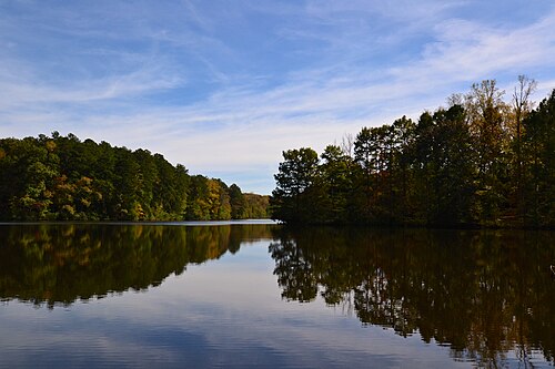
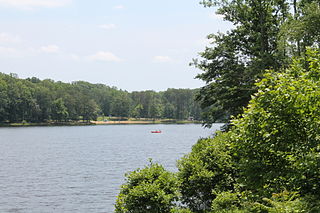
Warriors' Path State Park is a 950 acre (3.84 km²) Tennessee State Park in Colonial Heights, Kingsport, Sullivan County, Tennessee, in the United States. It is named for the Great Indian Warpath that was used by the Iroquois in war raids with the Cherokee and other tribes. The park is located around the Fort Patrick Henry Reservoir and Duck Island on the South Fork Holston River. This land was acquired from the Tennessee Valley Authority in 1952.

Tyler State Park (Texas)

Tyler State Park is a state park north of Tyler, Texas. It is 985.5 acres (399 ha) in Smith County, north of Tyler. The park includes a 64-acre (26 ha) lake. The land was deeded by private owners in 1934 and 1935; original improvements were made by the Civilian Conservation Corps (CCC). The park opened in 1939.

Bear Creek Lake State Park

Bear Creek Lake State Park is a 326-acre (132 ha) state park located in Cumberland, Virginia, United States. It is a recreational and camping facility that surrounds an artificial 40-acre (16 ha) lake situated in the 16,000-acre (6,500 ha) Cumberland State Forest.

Nickerson State Park

Nickerson State Park is a state-owned, public recreation area of more than 1,900 acres (770 ha) located on Cape Cod in Brewster, Massachusetts. The state park's sandy soil and scrub pines surround many kettle ponds which are dependent on groundwater and precipitation. The largest of these are Cliff Pond, Flax Pond, Little Cliff Pond, and Higgins Pond. Ruth Pond, Keeler's Pond, Eel Pond and Triangle Pond provide additional water habitats.

Wallowa Lake State Park

Wallowa Lake State Park is a state park located in northeast Oregon in the United States. It is at the southern shore of Wallowa Lake, near the city of Joseph in Wallowa County. The town of Wallowa Lake is situated next to the park.

The Bay-Lakes Council is the Boy Scouts of America (BSA) council serving eastern Wisconsin and Upper Michigan. Headquartered in Appleton, Wisconsin, it is geographically one of the largest local BSA councils. Bay-Lakes Council #635 was formed on July 1, 1973, the product of a merger between six east Wisconsin councils. The council is served by Kon Wapos Lodge #635 of the Order of the Arrow.

Lake Wister State Park

Lake Wister State Park is a 3,428-acre (13.87 km2) Oklahoma state park located in Le Flore County, Oklahoma. It is located near the city of Wister, Oklahoma.

Daingerfield State Park

Daingerfield State Park, in Morris County southwest of Texarkana, is a 506.913-acre (2.05140 km2) recreational area, deeded in 1935 by Georgia Anna 'Chambers' Connor, and opened in 1938.

Calhoun Falls State Park

Calhoun Falls State Park is a state park located on the shores of Lake Russell near the town of Calhoun Falls in Abbeville County, South Carolina.

North Hero State Park is a 399-acre day use state park on Lake Champlain in North Hero, Vermont. It is a stop on the Lake Champlain Paddlers' Trail.

References

  1. The Natchez Trace; Tennessee Yesterday website; accessed April 2014.
  2. 1 2 The Natchez Trace; Tennessee State Official Website; "Environment – Parks;" accessed April 2014.