Wildersville, Tennessee | |
|---|---|
 Wildersville  Wildersville | |
| Coordinates: 35°46′53″N88°21′37″W / 35.78139°N 88.36028°W | |
| Country | United States |
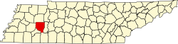
| State | Tennessee |
| County | Henderson |
| Area | |
• Total | 1.68 sq mi (4.36 km2) |
| • Land | 1.68 sq mi (4.36 km2) |
| • Water | 0 sq mi (0.00 km2) |
| Elevation | 479 ft (146 m) |
| Population | |
• Total | 161 |
| • Density | 95.6/sq mi (36.91/km2) |
| Time zone | UTC-6 (Central (CST)) |
| • Summer (DST) | UTC-5 (CDT) |
| ZIP code | 38388 |
| Area code | 731 |
| GNIS feature ID | 1274564 [3] |
Wildersville is an unincorporated community in Henderson County, Tennessee, United States. [3] The zipcode is 38388. [4]
In 1999, Carolina Panthers wide receiver Rae Carruth was arrested in the parking lot of Best Western hotel in Wildersville. He was founding hiding in the trunk of his car. [5]