Reagan, Henderson County, Tennessee | |
|---|---|
 Reagan  Reagan | |
| Coordinates: 35°31′18″N88°20′33″W / 35.52167°N 88.34250°W | |
| Country | United States |
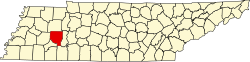
| State | Tennessee |
| County | Henderson |
| Elevation | 591 ft (180 m) |
| Time zone | UTC-6 (Central (CST)) |
| • Summer (DST) | UTC-5 (CDT) |
| ZIP code | 38368 |
| Area code | 731 |
| GNIS feature ID | 1299015 [1] |
Reagan is an unincorporated community in Henderson County, Tennessee, United States. [1] Its ZIP code is 38368. [2]
Reagan was originally called "Barren Springs", and under the latter name was founded in 1881. [3] A post office called Reagan has been in operation since 1884. [4]