Luray, Tennessee | |
|---|---|
 Luray  Luray | |
| Coordinates: 35°35′29″N88°34′33″W / 35.59139°N 88.57583°W | |
| Country | United States |
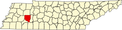
| State | Tennessee |
| County | Henderson |
| Area | |
• Total | 3.27 sq mi (8.47 km2) |
| • Land | 3.27 sq mi (8.47 km2) |
| • Water | 0 sq mi (0.00 km2) |
| Elevation | 407 ft (124 m) |
| Population | |
• Total | 197 |
| • Density | 60.2/sq mi (23.25/km2) |
| Time zone | UTC-6 (Central (CST)) |
| • Summer (DST) | UTC-5 (CDT) |
| ZIP code | 38352 |
| Area code | 731 |
| GNIS feature ID | 1292294 [3] |
Luray is an unincorporated community in Henderson County, Tennessee, United States. [3] The zipcode is: 38352. [4]