Chickamauga and Chattanooga National Military Park

Last updated
Chickamauga and Chattanooga National Military Park
Cannon Row.jpg
Cannon Row
USA Tennessee relief location map.svg
Red pog.svg
Location in Tennessee
Usa edcp relief location map.png
Red pog.svg
Location in United States
Location Catoosa, Dade, & Walker County, Georgia & Hamilton County, Tennessee, United States
Nearest city Chattanooga, Tennessee
Coordinates 34°56′24″N85°15′36″W / 34.94000°N 85.26000°W / 34.94000; -85.26000
Area9,523 acres (38.54 km2) [1]
EstablishedAugust 19, 1890
Visitors977,158(in 2019) [2]
Governing body National Park Service
Website Chickamauga and Chattanooga National Military Park
Chickamauga and Chattanooga National Military Park
LocationS of Chattanooga on U.S. 27, Fort Oglethorpe, Georgia
Built1890
Built by United States War Department, National Park Service
Architectural style Bungalow/Craftsman, Single-pen log cabin
NRHP reference No. 66000274 [3]
Added to NRHPOctober 15, 1966

Wilder Brigade Monument at the Chickamauga Battlefield unit Battlefield 9.jpg
Wilder Brigade Monument at the Chickamauga Battlefield unit

Chickamauga and Chattanooga National Military Park, located in northern Georgia and southeastern Tennessee, preserves the sites of two major battles of the American Civil War: the Battle of Chickamauga and the Siege of Chattanooga. A detailed history of the park's development was provided by the National Park Service in 1998. [4]

Contents

History

Starting in 1890, during the decade, the Congress of the United States authorized the establishment of the first four national military parks: Chickamauga and Chattanooga, Shiloh, Gettysburg and Vicksburg.

The first and largest of these (5,300 acres or 2,145 ha), and the one upon which the establishment and development of most other national military and historical parks was based, was authorized in 1890 at Chickamauga, Georgia and Chattanooga, Tennessee. It was officially dedicated in September 1895. [5] It owes its existence chiefly to the efforts of Generals Henry V. Boynton and Ferdinand Van Derveer, both veterans of the Union Army of the Cumberland, who saw the need for a federal park to preserve and commemorate these battlefields. [6] Another early proponent and driving force behind the park's creation was Ohio General Henry M. Cist, who led the Chickamauga Memorial Society in 1888. Franklin Guest Smith, a former Union officer still on active duty, served as secretary and member of the board of commissioners from 1893 until his 1903 military retirement, and served in the same role as a civilian until 1908. [7] Another former Union officer, Charles H. Grosvenor, was chairman of the park commission from 1910 until his death in 1917. During the Park's early years, it was managed by the War Department and used for military study as well as a memorial. The National Park Service took over site management in 1933. [8]

Use during the Spanish–American War

The newly created Chickamauga and Chattanooga National Military Park was used during the Spanish–American War as a major training center for troops in the southern states. The park was temporarily renamed "Camp George H. Thomas" in honor of the union army commander during the Civil War battle at the site. The park's proximity to the major rail hub at Chattanooga and its large tracts of land made it a logical marshalling area for troops being readied for service in Cuba and other points south. [9] [10]

Park areas

The military park consists of four main areas, and a few small isolated reservations, around Chattanooga.

On October 15, 1966, as with all historic areas already administered by the National Park Service, the military park was listed on the National Register of Historic Places.

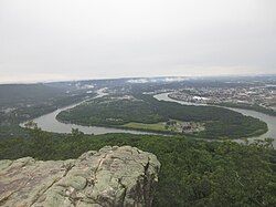
On February 20, 2003, Public Law No: 108-7 added Moccasin Bend as a new unit of the park. Moccasin Bend Archaeological District, designated a National Historic Landmark on September 8, 1986, is directly across the Tennessee River from Lookout Mountain. It is significant due to its archaeological resources of American Indian settlement. There are currently minimal visitor services at Moccasin Bend, including two hiking trails (the Blue Blazes Trail and the Browns Ferry Road) and a ten-acre meadow. Each of these areas is open to the public. The park anticipates further development, land restoration, and visitor services in the years to come. [11]

Chattanooga and Moccasin Bend viewed from the Lookout Mountain unit View of Chattanooga and Moccasin Bend from the Lookout Mountain unit.jpg
Chattanooga and Moccasin Bend viewed from the Lookout Mountain unit

See also

Related Research Articles

<span class="mw-page-title-main">Colonial National Historical Park</span> Historic site in Hampton Roads, Virginia, US

Colonial National Historical Park is a large national historical park located in the Hampton Roads region of Virginia operated by the National Park Service. It protects and interprets several sites relating to the Colony of Virginia and the history of the United States more broadly. These range from the site of the first English settlement at Jamestown, to the battlefields of Yorktown where the British Army was defeated in the American Revolutionary War. Over 3 million people visit the park each year.

<span class="mw-page-title-main">Lake Mead National Recreation Area</span> U.S. protected area in Nevada and Arizona

Lake Mead National Recreation Area is a U.S. national recreation area in southeastern Nevada and northwestern Arizona. Operated by the National Park Service, Lake Mead NRA follows the Colorado River corridor from the westernmost boundary of Grand Canyon National Park to just north of the cities of Laughlin, Nevada and Bullhead City, Arizona. It includes all of the eponymous Lake Mead as well as the smaller Lake Mohave – reservoirs on the river created by Hoover Dam and Davis Dam, respectively – and the surrounding desert terrain and wilderness.

<span class="mw-page-title-main">Shiloh National Military Park</span> Historic Civil War site in Hardin County, Tennessee

Shiloh National Military Park preserves the American Civil War Shiloh and Corinth battlefields. The main section of the park is in the unincorporated town of Shiloh, about nine miles (14 km) south of Savannah, Tennessee, with an additional area located in the city of Corinth, Mississippi, 23 miles (37 km) southwest of Shiloh. The Battle of Shiloh began a six-month struggle for the key railroad junction at Corinth. Afterward, Union forces marched from Pittsburg Landing to take Corinth in a May siege, then withstood an October Confederate counter-attack.

<span class="mw-page-title-main">Going-to-the-Sun Road</span> United States historic place

Going-to-the-Sun Road is a scenic mountain road in the Rocky Mountains of the western United States, in Glacier National Park in Montana. The Sun Road, as it is sometimes abbreviated in National Park Service documents, is the only road that traverses the park, crossing the Continental Divide through Logan Pass at an elevation of 6,646 feet (2,026 m), which is the highest point on the road. Construction began in 1921 and was completed in 1932 with formal dedication in the following summer on July 15, 1933. Prior to the construction of the road, visitors would need to spend several days traveling through the central part of the park, an area which can now be traversed within a few hours, excluding any stops for sightseeing or construction.

<span class="mw-page-title-main">Selfridge Air National Guard Base</span> Air National Guard base in Michigan, USA

Selfridge Air National Guard Base or Selfridge ANGB is an Air National Guard installation located in Harrison Township, Michigan, near Mount Clemens. Selfridge Field was one of thirty-two Air Service training camps established after the United States entry into World War I in April 1917.

<span class="mw-page-title-main">Vicksburg National Military Park</span> American Civil War historic site

Vicksburg National Military Park preserves the site of the American Civil War Battle of Vicksburg, waged from March 29 to July 4, 1863. The park, located in Vicksburg, Mississippi, also commemorates the greater Vicksburg Campaign which led up to the battle. Reconstructed forts and trenches evoke memories of the 47-day siege that ended in the surrender of the city. Victory here and at Port Hudson, farther south in Louisiana, gave the Union control of the Mississippi River.

<span class="mw-page-title-main">Moccasin Bend</span> United States historic place

Moccasin Bend Archeological District is an archeological site in Chattanooga, Tennessee, that is part of the Chickamauga and Chattanooga National Military Park unit. The National Park Service refers to it as one of the "most unique units found in the entire National Park Service." The area contains remnants of 12,000 years of continuous human habitation and serves as an area with unique cultural significance. For many years, there was little recognition of the historical significance of the area, and years of industrial development occurred on and around sites of archeological importance. After decades of campaigning by concerned citizens, private organizations, local officials, the Friends of Moccasin Bend National Park, and finally a state representative, the area was officially recognized as a National Archeological District in 2003. Moccasin Bend is currently undergoing a process of renovation and restoration that will allow the area to fulfill the National Park Service's mission of preserving "natural and cultural resources" for the "enjoyment, education, and inspiration of this and future generations."

<span class="mw-page-title-main">Antietam National Battlefield</span> Historical area from the American Civil War

Antietam National Battlefield is a National Park Service-protected area along Antietam Creek in Sharpsburg, Washington County, northwestern Maryland. It commemorates the American Civil War Battle of Antietam that occurred on September 17, 1862.

<span class="mw-page-title-main">Fredericksburg and Spotsylvania National Military Park</span> American Civil War battlefields in Virginia

Fredericksburg and Spotsylvania National Military Park is a unit of the National Park Service in Fredericksburg, Virginia, and elsewhere in Spotsylvania County, commemorating four major battles in the American Civil War: Fredericksburg, Chancellorsville, The Wilderness, and Spotsylvania.

Stones River National Battlefield, a 570-acre (2.3 km2) park along the Stones River in Rutherford County, Tennessee, three miles (5 km) northwest of Murfreesboro and twenty-eight miles southeast of Nashville, memorializes the Battle of Stones River. This key battle of the American Civil War occurred on December 31, 1862 and January 2, 1863, and resulted in a strategic Union victory.

<span class="mw-page-title-main">Chattanooga National Cemetery</span> Historic veterans cemetery in Hamilton County, Tennessee

Chattanooga National Cemetery is a United States National Cemetery located near the center of the city of Chattanooga in Hamilton County, Tennessee. Administered by the United States Department of Veterans Affairs, it encompasses 120.9 acres (48.9 ha), and as of 2014, had more than 50,000 interments.

<span class="mw-page-title-main">Port Hudson National Cemetery</span> Historic veterans cemetery in East Baton Rouge Parish, Louisiana

Port Hudson National Cemetery is a United States National Cemetery located in Port Hudson, 20 miles (32 km) north of the city of Baton Rouge in East Baton Rouge Parish, Louisiana. Administered by the United States Department of Veterans Affairs, it encompasses 19.9 acres (8.1 ha), and as of the end of 2020, had over 12,000 interments.

<span class="mw-page-title-main">Watervliet Arsenal</span> US Army installation in Watervliet, New York

The Watervliet Arsenal (WVA) is an arsenal of the United States Army located in Watervliet, New York, on the west bank of the Hudson River. It is the oldest continuously active arsenal in the United States, and today produces much of the artillery for the army, as well as gun tubes for cannons, mortars, and tanks. It has been a National Historic Landmark (NHL) since 1966.

<span class="mw-page-title-main">Vandenberg Space Launch Complex 10</span> Rocket launch site at Vandenberg Space Force Base in the United States

Space Launch Complex 10, or Missile Launch Complex 10, is located on Vandenberg Space Force Base in Lompoc, California. It was built in 1958 to test ballistic missiles and developed into a space launching facility in 1963. Prior to 1966 Space Launch Complex 10 West was known as Vandenberg AFB Pad 75-2-6. It remains a rare pristine look at the electronics and facilities created in that era that helped the United States grow its space capabilities.

<span class="mw-page-title-main">Georgia State Railroad Museum</span> United States historic place

The Georgia State Railroad Museum is a museum in Savannah, Georgia located at a historic Central of Georgia Railway site. It includes parts of the Central of Georgia Railway: Savannah Shops and Terminal Facilities National Historic Landmark District. The complex is considered the most complete antebellum railroad complex in the United States. The museum, located at 655 Louisville Road, is part of a historic district included in the National Register of Historic Places.

<span class="mw-page-title-main">Central of Georgia Depot and Trainshed (Savannah, Georgia)</span>

Central of Georgia Depot and Trainshed is a former passenger depot and trainshed constructed in 1860 by the Central of Georgia Railway (CofG) before the outbreak of the American Civil War. This pair of buildings was declared a National Historic Landmark in 1976, a listing that was expanded in 1978 to the old Central of Georgia Railway Savannah Shops and Terminal Facilities.

<span class="mw-page-title-main">Grand Loop Road</span> United States historic place

The Grand Loop Road is a historic district which encompasses the primary road system in Yellowstone National Park. Much of the 140-mile (230 km) system was originally planned by Captain Hiram M. Chittenden of the US Army Corps of Engineers in the early days of the park, when it was under military administration. The Grand Loop Road provides access to the major features of the park, including the Upper, Midway and Lower geyser basins, Mammoth Hot Springs, Tower Fall, the Grand Canyon of the Yellowstone and Yellowstone Lake.

<span class="mw-page-title-main">Zion – Mount Carmel Highway</span> United States historic place

The Zion – Mount Carmel Highway is a 25-mile (40 km) long road in Washington and Kane counties in southern Utah, United States, that is listed on the National Register of Historic Places and is a National Historic Civil Engineering Landmark.

The Civil War Trust's Civil War Discovery Trail is a heritage tourism program that links more than 600 U.S. Civil War sites in more than 30 states. The program is one of the White House Millennium Council's sixteen flagship National Millennium Trails. Sites on the trail include battlefields, museums, historic sites, forts and cemeteries.

References

  1. "Listing of acreage – December 31, 2020" (XLSX). Land Resource Division, National Park Service. Retrieved August 15, 2021. (National Park Service Acreage Reports)
  2. "NPS Annual Recreation Visits Report". National Park Service. Retrieved December 26, 2012.
  3. "National Register Information System". National Register of Historic Places . National Park Service. July 9, 2010.
  4. Jill K. Hanson and Robert W. Blvthe (February 10, 1998). "National Register of Historic Places Registration: Chickamauga and Chattanooga National Military Park". National Park Service. and more than 100 accompanying photos
  5. Chickamauga and Chattanooga National Military Park (Ga. and Tenn.) Commission: Louisiana Committee Photographs (Mss. 4504), Louisiana and Lower Mississippi Valley Collections, LSU Libraries, Baton Rouge, Louisiana, USA. (accessed 26 January 2015) <http://www.louisianadigitallibrary.org/cdm/landingpage/collection/LSU_CNP>
  6. "Saving History for Generations: The Creation of the First Civil War Military Park", Hallowed Ground, Fall 2013, Vol.14, no. 3, pages 14-15.
  7. Suter, J. L., ed. (1908). District of Columbia: Concise Biographies of Its Prominent and Representative Contemporary Citizens. Washington, D.C.: Potomac Press. p. 434 via Google Books.
  8. "Saving History for Generations: The Creation of the First Civil War Military Park", Hallowed Ground, Fall 2013, Vol.14, no. 3, page 15.
  9. "The Troops at Chickamauga, Park now called Camp George H. Thomas". The New York Times. April 23, 1898. Retrieved February 1, 2010.
  10. "Spanish–American War". The Encyclopedia of Arkansas. Retrieved February 1, 2010.
  11. "Visit". Friends of Moccasin Bend. Archived from the original on April 12, 2016. Retrieved March 11, 2016.