Olgiati Bridge

Last updated
P. R. Olgiati Bridge
Olgiati-1960s.jpg
The Olgiati Bridge in the 1960s
Coordinates 35°03′28″N85°18′59″W / 35.0578°N 85.3164°W / 35.0578; -85.3164
Carries8 lanes of US 27.svg US 27 (SR 27/SR 29)
Crosses Tennessee River
Locale Chattanooga, Tennessee
Other name(s)Ol' Johnny
Named for P.R. Olgiati
Preceded by Market Street Bridge
Followed by Marion Memorial Bridge
Characteristics
Design Girder bridge
MaterialSteel
History
Construction end
  • November 20, 1959 [1] (initial construction)
  • February 2003 (widening)
  • 2020 (additional widening; expected)
Statistics
Daily traffic 68,831 (2018) [2]
Location
Olgiati Bridge

The P. R. Olgiati Bridge, often called the "Ol' Johnny" or "Ol' Jolly", [3] is a steel girder bridge across the Tennessee River in Chattanooga, Tennessee completed in 1959. It is named for former mayor and long time political boss of Chattanooga, P.R. Olgiati. Chattanooga was a growing city during the 1950s. To expand the city and to allow more ways to cross the Tennessee River, the P. R. Olgiati Bridge was one of multiple bridges built. The route carries US 27 across the Tennessee river.

Contents

Description

The P. R. Olgiati Bridge is located in Chattanooga, Tennessee. The bridge is one of several major bridges that crosses the Tennessee River in Chattanooga. These bridges include the Walnut Street Bridge, Market Street Bridge, Veterans Memorial Bridge, and Wilkes T. Thrasher Bridge. The P. R. Olgiati Bridge carries a controlled-access portion of US 27, which is a U.S. highway that travels south to north. The bridge crosses the Tennessee River just north of downtown, and links the freeway across the ridge en route to Signal Mountain and Red Bank. [4] Surrounding the bridge is the Tennessee Riverwalk on the south side and just before getting to the bridge, US 27 crosses Riverfront Parkway.

History

A few years before the idea for the Olgiati Bridge became a discussion, the Wilkes T. Thrasher Bridge had been built in 1955 to provide a way of traveling across the Tennessee River. [5] The Wilkes T. Thrasher bridge and others were built to help the growth of Chattanooga and to expand the use of the river, as well as to provide more ways of travel. Born a native Tennessean in 1901, Peter Rudolph Olgiati, mainly known as P.R. Olgiati, was appointed to the City Commission and filled the seat of an unexpired term, and later became mayor of Chattanooga for 12 years. He supported the expansion of Chattanooga and building bridges was part of his plan. [6] The bridge expansions were made to contribute to the growth of Chattanooga and to expand the use of the river, as well as to provide more ways of travel for anyone passing through the area.

Construction

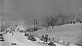
From 1946 to 1951, P.R. Olgiati was appointed to the City Commission and was elected as mayor of Chattanooga and held his position as mayor for 12 years. Olgiati became a man with great authority, power, and responsibility. He ran many of the cities departments and could use his power as an advantage to improve the city. He began his term as mayor by working to draw the state and federal officials attention. After continuous efforts to gain the approval of federal and state officials, Olgiati was granted $100 million to build up the city. Because of his driven ideals, Chattanooga became the very first of any Tennessee major city to have a fully completed interstate system. [3] The new bridge was mainly built because of the excessively used and overcrowded Market and Walnut Street bridges. The bridge was a steel girder bridge, known to be built because they are a high weight supported system. [7] The girder refers to the I-beams that are made up of steel plates that are placed together in order to hold the bridge up. Steel bridges are known to be more costly, but, when built, are much more effective and safe. [8] Olgiati was given the resources to build a well built and supported bridge, which would greatly contribute to travel in Chattanooga. The site was approved in 1954, and construction began the next year. To begin the building process, about one thousand buildings had to be torn down and around 1,400 families had to move. The entire cost of the bridge was approximately $7 million (equivalent to $50.5 million in 2021 [9] ). The bridge opened to traffic on November 20, 1959. [1] Initially, the bridge was named Cedar Street Bridge, but soon after was renamed P. R. Olgiati Bridge in regards to Mr. Olgiati's efforts to expand Chattanooga. [3]

Recent developments

Beginning in February 1999, the Olgiati bridge was widened from four to six lanes. [10] This was accomplished by attaching extending steel beams to the top of the posts over the river. Also in this project, a ramp was added from the bridge on the north side to Manufacturer's Road, replacing a hazardous cloverleaf loop ramp which diverged past the bridge. The project, after many delays, was completed in February 2003. [10]

In 2011, TDOT announced a plan add two more lanes to the bridge. [10] The groundwork for extra lanes was already done in the first widening project. [10] The project has experienced many delays, but TDOT began widening the bridge in a reconstruction of the portion of US 27 in downtown Chattanooga (Interstate 124) which began in late 2015, and is expected to be completed by 2020. [11]

See also

Related Research Articles

<span class="mw-page-title-main">Interstate 24</span> Interstate Highway in Illinois, Kentucky, Tennessee, and Georgia

Interstate 24 (I-24) is an Interstate Highway in the Midwestern and Southeastern United States. It runs diagonally from I-57, 10 miles (16 km) south of Marion, Illinois, to Chattanooga, Tennessee, at I-75. It travels through Illinois, Kentucky, Tennessee, and Georgia. As an even-numbered Interstate, it is signed as an east–west route, though the route follows a more southeast–northwest routing, passing through Nashville, Tennessee. The numbering deviates from the standard Interstate Highway System grid, lying further north than its number would indicate west of Nashville. The short segment within Georgia bears the unsigned designation State Route 409 (SR 409).

<span class="mw-page-title-main">Chattanooga, Tennessee</span> City in Tennessee, United States

Chattanooga is a city in and the county seat of Hamilton County, Tennessee, United States. It is located along the Tennessee River, and borders Georgia to the south. With a population of 181,099 in 2020, it is Tennessee's fourth-largest city and one of the two principal cities of East Tennessee, along with Knoxville. It anchors the Chattanooga metropolitan area, Tennessee's fourth-largest metropolitan statistical area, as well as a larger three-state area that includes Southeast Tennessee, Northwest Georgia, and Northeast Alabama.

<span class="mw-page-title-main">Interstate 124</span> Highway in Tennessee

Interstate 124 (I-124) is an unsigned designation for a short segment of a controlled-access highway located in Chattanooga, Tennessee.

<span class="mw-page-title-main">Memphis & Arkansas Bridge</span> Highway bridge in Memphis, Tennessee, United States

The Memphis & Arkansas Bridge, also known as the Memphis–Arkansas Bridge or inaccurately as the Memphis–Arkansas Memorial Bridge, is a cantilevered through truss bridge carrying Interstate 55 across the Mississippi River between West Memphis, Arkansas and Memphis, Tennessee. Memphians refer to this bridge as the "Old Bridge" to distinguish it from the "New Bridge", or Hernando de Soto Bridge, upstream.

<span class="mw-page-title-main">U.S. Route 25E</span> Highway in Tennessee and Kentucky, United States

U.S. Route 25E (US 25E) is the eastern branch of US 25 from Newport, Tennessee, where US 25 splits into US 25E and US 25W, to North Corbin, Kentucky, where the two highways rejoin. The highway, however, continues as US 25E for roughly two miles (3.2 km) until it joins Interstate 75 (I-75) in the Laurel County community of North Corbin at exit 29. The highway serves the Appalachia regions of Kentucky's Cumberland Plateau and the Ridge-and-Valley section of East Tennessee, including the urbanized areas of Corbin and Middlesboro in Kentucky and Morristown in Tennessee.

<span class="mw-page-title-main">Veterans Memorial Bridge (Chattanooga)</span> Bridge

The Veterans Memorial Bridge is a steel girder bridge in Chattanooga, Tennessee. It was built in 1984 and has a main span of 420 feet (130 m). It carries Georgia Avenue across the Tennessee River, and Audubon Island, an island in the river on which McClellan Animal Sanctuary is located. It is one of four bridges that cross the Tennessee River at downtown Chattanooga.

<span class="mw-page-title-main">Wilkes T. Thrasher Bridge</span> Bridge

The Wilkes T. Thrasher Bridge is a 4-lane road bridge located in Chattanooga, Tennessee. It opened in 1955 as a two lane road after much pressure from Wilkes T. Thrasher, a prominent Hamilton County Judge, to the Federal Government. In the 1980's, the bridge was widened to four lanes. Traffic was rerouted via the neighboring C.B. Robinson Bridge carrying State Route 319 and carries Tennessee State Route 153 over the Chickamauga Dam crossing the Tennessee River. The bridge is highly unusual, Not only was it built directly on top of a dam, but it was built many years after the dam was built. A number of dams include bridge-like structures on them, that may be just for dam maintenance or may carry an actual highway. Typically however such structures are built at the same time as the dam. The Chickamauga Dam was built from 1936-1940. The bridge however was not built until 1954. The highly unusual design soars high above most of the dam to accommodate the height of the power house which it also passes over, and also to allow for maintenance vehicles on the dam below. Most structurally significant about the bridge itself are that many of the spans utilize a steel rigid-frame design. Steel rigid-frame bridges, particularly from the pre-1970 era when rivets were still used are extremely rare. Other spans on the bridge appear to be more traditional simple riveted deck plate girders and steel stringers.

<span class="mw-page-title-main">Interstate 40 in Tennessee</span> Interstate Highway in Tennessee, United States

Interstate 40 (I-40) is part of the Interstate Highway System that runs 2,556.61 miles (4,114.46 km) from Barstow, California, to Wilmington, North Carolina. The highway crosses Tennessee from west to east, from the Mississippi River at the Arkansas border to the Blue Ridge Mountains at the North Carolina border. At 455.28 miles (732.70 km), the Tennessee segment of I-40 is the longest of the eight states through which it passes and the state's longest Interstate Highway.

<span class="mw-page-title-main">Interstate 75 in Tennessee</span> Highway in Tennessee

Interstate 75 (I-75) in the US state of Tennessee runs from Chattanooga to Jellico by way of Knoxville. I-75 enters the East Tennessee region from Georgia, following the Tennessee Valley all the way through Knoxville to near Rocky Top, then climbs into the Cumberland Mountains before crossing over into Kentucky at Jellico.

<span class="mw-page-title-main">Tennessee Riverwalk</span>

The Tennessee Riverwalk is a 13-mile (21-km) riverside path which parallels the Tennessee River from the Chickamauga Dam to downtown Chattanooga, Tennessee. It is part of the Tennessee Riverpark System featuring the Tennessee Riverpark, Coolidge Park, Renaissance Park, Ross's Landing, the Walnut Street Bridge, the Blue Goose Hollow section and the old U.S. Pipe property.

<span class="mw-page-title-main">U.S. Route 27 in Tennessee</span> United States Numbered Highway in Tennessee

U.S. Route 27 in Tennessee runs from the Georgia state line in Chattanooga to the Kentucky state line in Isham. It forms the informal border between the Eastern and Central Time Zones of the state. However, it stays in the Eastern Time Zone.

<span class="mw-page-title-main">Tennessee State Route 397</span> Highway in Tennessee

State Route 397 (SR 397), also known as Mack Hatcher Memorial Parkway, is a primary state route that serves as a perimeter road for the city of Franklin, Tennessee. Throughout its length, SR 397 also carries the designations of U.S. Route 31 Truck and U.S. Route 431 Truck. The route connects multiple U.S. and state routes, and serves as a bypass around the business district of Franklin, as well as a major thoroughfare.

<span class="mw-page-title-main">U.S. Route 64 in Tennessee</span>

In Tennessee, U.S. Route 64 stretches 404.1 miles (650.3 km) from the Mississippi River in Memphis to the North Carolina state line near Ducktown. The highway, along with US 72, is a major route for travel between Memphis and Chattanooga.

<span class="mw-page-title-main">Tennessee State Route 153</span> Highway in Tennessee

State Route 153 is a state highway in Chattanooga, Tennessee. It runs from Interstate 75/U.S. Route 74 (I-75/US 74) a few miles east of the I-24 interchange, to US 27 just south of Soddy-Daisy. The route serves as a bypass around downtown Chattanooga for I-75 travelers heading towards US 27 north. It is also an important route for drivers from Soddy-Daisy, Hixson, and other parts of northwestern Hamilton County who are heading for I-75 and the eastern half of the county. It is also an important link to the Tennessee Valley Authority Chickamauga Dam, which the highway crosses on the Wilkes T. Thrasher Bridge. It also serves as the primary access to the Chattanooga Metropolitan Airport.

<span class="mw-page-title-main">Tennessee State Route 60</span> Highway in Tennessee

State Route 60 is a north-south major state route in Eastern Tennessee. It covers 54 miles (87 km) and runs from the Tennessee-Georgia state line in Bradley County to Dayton joining US 27.

The following is a timeline of the history of the city of Chattanooga, Tennessee, United States.

<span class="mw-page-title-main">APD-40</span> Highway in Cleveland, Tennessee, United States

APD-40 or APD 40 refers to a road composed of the U.S. Route 64 Bypass and a section of State Route 60 (SR 60) which forms a partial beltway around the business district of Cleveland, Tennessee. The route takes its name from its part of Corridor K of the Appalachian Development Highway System, and is sometimes called Appalachian Highway or simply the Cleveland Bypass. The route is also designated as Veterans Memorial Highway. The US 64 Byp. section of the road is also multiplexed with unsigned State Route 311 and US 74. The road is a four-lane divided highway its entire length and parts are controlled-access. The bypass is an east-west route and the state route is a north-south.

<span class="mw-page-title-main">P.R. Olgiati</span> 55th Mayor of Chattanooga, Tennessee from 1951 to 1963

Peter Rudolph "Rudy" Olgiati was the 55th Mayor of Chattanooga, Tennessee from 1951 to 1963. During his time in office, Olgiati oversaw the arrival of the interstate highway, the beginning of the Civil Rights Movement, and the city's first urban renewal project. He is often accused of being one of Chattanooga's last political bosses. He is also the namesake of Chattanooga's P.R. Olgiati Bridge.

Olgiati is an Italian and Swiss surname. Notable people with this name include:

The 75/24 Split, also commonly known simply as "The Split", is the name given to the interchange between Interstates 75 and 24 in Chattanooga, Tennessee. The interchange was originally constructed between 1959 and 1961 as a simple directional-T interchange. Although Chattanooga is only a mid-sized city by national standards, the interchange is the convergence point of two major north-south freight corridors, running between Atlanta and Detroit, and Atlanta and Chicago, respectively. As a result, the interchange has been ranked as one of the most congested bottlenecks in the country, rendering its original design obsolete, and has become notorious for congestion and accidents. The interchange is currently undergoing extensive reconstruction in two phases.

References

  1. 1 2 Gibson, Springer (November 21, 1959). "Olgiati Bridge Dedicated as $7,000,000 Link in City's Chain of Progress". Chattanooga Daily Times . Chattanooga, Tennessee. p. 1. Retrieved 2020-02-29 via Newspapers.com.
  2. Tennessee Department of Transportation. "Traffic History". ArcGIS . Esri . Retrieved July 18, 2020.
  3. 1 2 3 "Why did they name it the "Ol' Johnny Bridge?" | David Carroll's Chattanooga Radio and TV". www.chattanoogaradiotv.com. 24 October 2013. Retrieved 2015-10-06.
  4. Crutchfield, Jennifer (2010). Chattanooga Landmarks. The History Press. p. 75. ISBN   978-1-59629-447-9.
  5. "Chattanooga: History - Native Americans Displaced by Early Settlers". www.city-data.com. Retrieved 2015-09-29.
  6. "1951-1963 Peter Rudolph "Rudy" Olgiati". www.chattanooga.gov. Retrieved 2015-10-06.
  7. Wright, Ken (2012). Steel Bridge Design Handbook Volume 6. U.S. Department of Transportation Federal Highway Administration. pp. 3–4.
  8. Xanthakos, Petros (1994). Theory and Design of Bridges. New York: A Wiley-Interscience Publication. p. 531. ISBN   0-471-57097-4.
  9. Johnston, Louis; Williamson, Samuel H. (2023). "What Was the U.S. GDP Then?". MeasuringWorth. Retrieved January 1, 2023. United States Gross Domestic Product deflator figures follow the Measuring Worth series.
  10. 1 2 3 4 Carroll, Beverly (December 5, 2011). "Preparations for $11 million widening of Olgiati Bridge on track". The Chattanoogan. Chattanooga. Retrieved 2016-01-04.
  11. Cobb, David (November 15, 2015). "U.S. 27 rebuild from Olgiati to I-24 about to begin". Chattanooga Times Free Press. Chattanooga. Retrieved 2016-01-04.