
Montgomery County is a county in the U.S. state of Tennessee. As of the 2020 United States census, the population was 220,069. The county seat is Clarksville. The county was created in 1796. Montgomery County is included in the Clarksville, TN–KY Metropolitan Statistical Area.
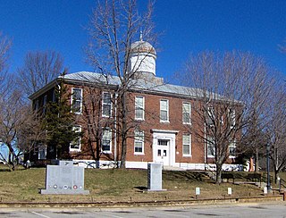
Dickson County is a county located in the U.S. state of Tennessee. As of the 2020 census, the population was 54,315. Its county seat is Charlotte. Dickson County is part of the Nashville-Davidson–Murfreesboro–Franklin, TN Metropolitan Statistical Area. Dickson County is home to Tennessee's oldest courthouse in continuous use, built in 1835. This is the second courthouse in Charlotte as the first one, a log building, was destroyed in the Tornado of 1833, which destroyed all but one building on the courthouse square.

Davidson County is a county in the U.S. state of Tennessee. It is located in the heart of Middle Tennessee. As of the 2020 census, the population was 715,884, making it the second most populous county in Tennessee. Its county seat is Nashville, the state capital and largest city.

Cheatham County is a county located in the U.S. state of Tennessee. As of the 2020 census, the population was 41,072. Its county seat is Ashland City. Cheatham County is part of the Nashville-Davidson–Murfreesboro–Franklin, TN Metropolitan Statistical Area. It is located in Middle Tennessee.
Ashland City is a town in and the county seat of Cheatham County, Tennessee, United States. The population was 5,193 as of the 2020 census.

The Little Tennessee River is a 135-mile (217 km) tributary of the Tennessee River that flows through the Blue Ridge Mountains from Georgia, into North Carolina, and then into Tennessee, in the southeastern United States. It drains portions of three national forests— Chattahoochee, Nantahala, and Cherokee— and provides the southwestern boundary of the Great Smoky Mountains National Park.

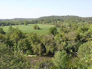
The Harpeth River, 115 miles (185 km) long, is one of the major streams of north-central Middle Tennessee, United States, and one of the major tributaries of the Cumberland River. Via the Cumberland and the Ohio Rivers, it is part of the Mississippi River watershed. The lower portion of the Harpeth is designated as a "scenic river" under the Tennessee Scenic Rivers Act.
The Pinson Mounds comprise a prehistoric Native American complex located in Madison County, Tennessee, in the region that is known as the Eastern Woodlands. The complex, which includes 17 mounds, an earthen geometric enclosure, and numerous habitation areas, was most likely built during the Middle Woodland period. The complex is the largest group of Middle Woodland mounds in the United States. Sauls' Mound, at 72 feet (22 m), is the second-highest surviving mound in the United States.
This is a list of properties and historic districts in Tennessee that are listed on the National Register of Historic Places. There are over 2,000 in total. Of these, 29 are National Historic Landmarks. Each of Tennessee's 95 counties has at least one listing.

Montgomery Bell was a manufacturing entrepreneur who was crucial to the economic development of early Middle Tennessee. He was known as the "Iron Master of the Harpeth" and the "Iron Master of Middle Tennessee". Today he is remembered mostly for founding Montgomery Bell Academy, one of the largest private non-sectarian all-boys high schools in the United States.

South Cumberland State Park is a state park in the middle and southeast portions of Tennessee on the Cumberland Plateau.
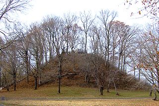
Mound Bottom is a prehistoric Native American complex in Cheatham County, Tennessee, located in the Southeastern United States. The complex, which consists of earthen platform and burial mounds, a 7-acre central plaza, and habitation areas, was occupied between approximately 1000 and 1300 AD, during the Mississippian period.

The Montgomery Bell Tunnel, also known as the Patterson Forge Tunnel, is a historic water diversion tunnel in Harpeth River State Park in Cheatham County, Tennessee. Built in 1819, the 290-foot (88 m) long tunnel is believed to be the first full-size tunnel built in the United States, and is the first used to divert water for industrial purposes. It was designated a Historic Civil Engineering Landmark in 1981, and a National Historic Landmark in 1994.

Graham Cave is a Native American archeological site near Mineola, Missouri in Montgomery County in the hills above the Loutre River. It is located in the 356 acre Graham Cave State Park. The entrance of the sandstone cave forms a broad arch 120 feet (37 m) wide and 16 feet (5 m) high. Extending about 100 feet (30 m) into the hillside, the cave protects an historically important Pre-Columbian archaeological site from the ancient Dalton and Archaic period dating back to as early as 10,000 years ago.

The C.H. Nash Museum at Chucalissa is located on and exhibits excavated materials of the Mississippian culture archaeological site known as Chucalissa which means "abandoned house" in Chickasaw. The site is located adjacent to the T. O. Fuller State Park within the city of Memphis, Tennessee, United States. Chucalissa was designated National Historic Landmark in 1994 due to its importance as one of the best-preserved and major prehistoric settlement sites in the region.

The Walls phase is an archaeological phase in southwestern Tennessee and northwestern Mississippi of the Late Mississippian culture. Chucalissa is a Walls phase mound and plaza complex located on a bluff overlooking the Mississippi River. Other contemporaneous groups in the area include the Parkin phase, Tipton phase, Menard phase, and the Nodena phase. The Walls phase is the last prehistoric people to inhabit the Memphis area before the arrival of Europeans. During the early 1540s the Hernando de Soto Expedition passed through the area, stopping at many villages along the way. It is thought that the Walls phase may be the Province of Quizquiz, a Tunican people encountered by de Soto on the banks of the Mississippi River.

Old Town is an archaeological site in Williamson County, Tennessee near Franklin. The site includes the remnants of a Native American village and mound complex of the Mississippian culture, and is listed on the National Register of Historic Places (NRHP) as Old Town Archaeological Site (40WM2).
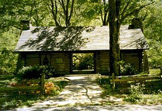
Montgomery Bell State Park is a Tennessee state park in Burns, Tennessee, United States. The park covers 3,782 acres (1,531 ha) and its official elevation is 758 feet (231 m). However, due to the dissected wooded terrain typical of the Nashville Basin, actual elevations range from 580 feet to 860 feet. The park is open for year-round recreation including boating, hiking, camping, fishing and golf. Montgomery Bell State Park was built during the Great Depression by members of the Works Progress Administration and Civilian Conservation Corps as Montgomery Bell Recreational Demonstration Area. Named for iron industrialist Montgomery Bell, the park is known as the birthplace of the Cumberland Presbyterian Church.

The Alabama Black Belt National Heritage Area is a National Heritage Area encompassing Bibb, Bullock, Butler, Choctaw, Clarke, Conecuh, Dallas, Greene, Hale, Lowndes, Macon, Marengo, Monroe, Montgomery, Perry, Pickens, Sumter, Washington, and Wilcox counties in the Black Belt region of Alabama. The Center for the Study of the Black Belt at the University of West Alabama serves as the local coordinating authority.

