A request that this article title be changedto National military park is under discussion. Please do not move this article until the discussion is closed.
National Military Park, National Battlefield, National Battlefield Park, and National Battlefield Site are four designations for 25 battle sites preserved by the United Statesfederal government because of their national importance. The designation applies to "sites where historic battles were fought on American soil during the armed conflicts that shaped the growth and development of the United States...."[1]
There are eleven National Battlefields (NB), nine National Military Parks (NMP), four National Battlefield Parks (NBP), and one National Battlefield Site (NBS). The National Park Service does not distinguish among the four designations in terms of their preservation or management policies.
National Historic Site (NHS) and National Historical Park (NHP) are designations for officially recognized areas of national historic significance in the United States. They are usually owned and managed by the federal government. An NHS usually contains a single historical feature directly associated with its subject, while an NHP is an area that generally extends beyond single properties or buildings to include a mix of historic and later structures and sometimes significant natural features.
The Battle of Cedar Creek, or Battle of Belle Grove, was fought on October 19, 1864, during the American Civil War. The fighting took place in the Shenandoah Valley of Northern Virginia, near Cedar Creek, Middletown, and the Valley Pike. During the morning, Lieutenant General Jubal Early appeared to have a victory for his Confederate army, as he captured over 1,000 prisoners and over 20 artillery pieces while forcing 7 enemy infantry divisions to fall back. The Union army, led by Major General Philip Sheridan, rallied in late afternoon and drove away Early's men. In addition to recapturing all of their own artillery seized in the morning, Sheridan's forces captured most of Early's artillery and wagons.
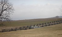
The Battle of Natural Bridge was fought during the American Civil War in what is now Woodville, Florida near Tallahassee on March 6, 1865. A small group of Confederate troops and volunteers, which included teenagers from the nearby Florida Military and Collegiate Institute that would later become Florida State University, protected by breastworks, prevented a detachment of United States Colored Troops from crossing the Natural Bridge on the St. Marks River.
Mackinac Island State Park is a state park located on Mackinac Island in the U.S. state of Michigan. A Lake Huron island, it is near the Straits of Mackinac. The island park encompasses 1,800 acres (7.3 km2), which is approximately 80% of the island's total area. The park is also within the boundaries of the city of Mackinac Island and has permanent residents within its boundaries. M-185 circles the perimeter of the park as the only motorless highway in the state due to the island's ban of automobiles. The park is governed by the Michigan Department of Natural Resources and the Mackinac Island State Park Commission. On July 15, 2009, the park celebrated its 20 millionth visitor.
Little Bighorn Battlefield National Monument preserves the site of the June 25 and 26, 1876, Battle of the Little Bighorn, near Crow Agency, Montana, in the United States. It also serves as a memorial to those who fought in the battle: George Armstrong Custer's 7th Cavalry and a combined Lakota-Northern Cheyenne and Arapaho force. Custer National Cemetery, on the battlefield, is part of the national monument. The site of a related military action led by Marcus Reno and Frederick Benteen is also part of the national monument, but is about 3 miles (4.83 km) southeast of the Little Bighorn battlefield.
Saratoga National Historical Park is a United States National Historical Park located in the Town of Stillwater in eastern New York, 30 miles north of Albany. The park preserves the site of the Battles of Saratoga.
Buildings, sites, districts, and objects in Virginia listed on the National Register of Historic Places:
Cedar Creek and Belle Grove National Historical Park became the 388th unit of the United States National Park Service when it was authorized on December 19, 2002. The National Historical Park was created to protect several historically significant locations in the Shenandoah Valley of Northern Virginia, notably the site of the American Civil War Battle of Cedar Creek and the Belle Grove Plantation.
The 8th Vermont Infantry Regiment was a three-year infantry regiment in the Union Army during the American Civil War. It served in both major theaters, first in Louisiana and then in Virginia, from February 1862 to June 1865. It was a member of the XIX Corps.
Bentonville Battlefield is a North Carolina state historic site at 5466 Harper House Road in Johnston County, North Carolina. It belongs to the North Carolina Department of Natural and Cultural Resources and is the site of the 1865 Battle of Bentonville, fought in the waning days of the American Civil War. It was declared a National Historic Landmark in 1996.
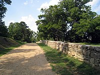
The Port Hudson State Historic Site is located on the Mississippi River north of Baton Rouge in East Feliciana Parish, Louisiana, just outside the limits of Port Hudson and in the vicinity of Jackson. The site preserves a portion of the fortifications and battle area of the longest siege in American history, during the American Civil War from May 23 through July 9, 1863. The state of Louisiana maintains the site, which includes a museum about the siege, artillery displays, redoubts, and interpretive plaques. Historical reenactments are held each year. It was designated a National Historic Landmark in 1974, significant as the first place where African-American military units fought for the Union Army under African-American field leadership.
Since 1872 the United States National Park System has grown from a single, public reservation called Yellowstone National Park to include 430 natural, historical, recreational, and cultural areas throughout the United States, its territories, and island possessions. These areas include National Parks, National Monuments, National Memorials, National Military Parks, National Historic Sites, National Parkways, National Recreation Areas, National Seashores, National Scenic Riverways, and National Scenic Trails.
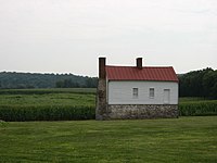
The River Raisin National Battlefield Park preserves the site of the Battle of Frenchtown as the only national battlefield marking a site of the War of 1812. It was established as the 393rd unit of the United States National Park Service under Title VII of the Omnibus Public Land Management Act, which was signed into law on March 30, 2009. The park is located in the city of Monroe in Monroe County, Michigan. It was designated as a Michigan Historic Site on February 18, 1956 and was added to the National Register of Historic Places on December 10, 1982. The house at 1403 East Elm Avenue was added to the National Register listing in 2019. It officially began operation as a national park unit on October 22, 2010.
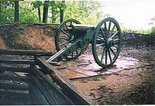
Fort Davidson, a fortification near the town of Pilot Knob, Missouri, was the site of the Battle of Fort Davidson during the American Civil War. Built by Union Army soldiers during the American Civil War, the fort repulsed Confederate attacks during the Battle of Fort Davidson on September 27, 1864, during Price's Raid. That night, the Union garrison blew up the fort's magazine and abandoned the site. A mass grave was constructed on the site to bury battlefield dead. After the war, the area was used by a mining company, before passing into private hands and eventually the administration of the United States Forest Service. In 1968, the Battle of Pilot Knob State Historic Site was created as a Missouri State Park. The fort itself was added to the National Register of Historic Places in 1970. As of 2020, a visitors center containing a museum is located within the park. The museum contains a fiber optic display, as well as artifacts including Brigadier General Thomas Ewing Jr.'s sword. The fort's walls are still visible, as is the crater created when the magazine was detonated. A monument marks the location of the mass grave.
Belle Grove Plantation is a late-18th-century plantation house and estate in the northern Shenandoah Valley of Virginia, USA. It is situated in Frederick County, about a mile southwest of Middletown.
The Civil War Trust's Civil War Discovery Trail is a heritage tourism program that links more than 600 U.S. Civil War sites in more than 30 states. The program is one of the White House Millennium Council's sixteen flagship National Millennium Trails. Sites on the trail include battlefields, museums, historic sites, forts and cemeteries.
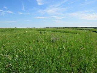
Fort Juelson, designated 21OT198 in the state archaeological inventory, is a historic site located east of Underwood, Minnesota, United States. An earthen fort was built at this hilltop in July 1876 after rumors of Indian attacks in Foxhome, French, and Fergus Falls following the Battle of Little Bighorn in Montana. Many settlers left the area. Charles A. Dollner, a local merchant, suggested the rest of the people band together and build the fortification under leadership of two American Civil War veterans, Hans Juelson and Berge O. Lee. The scare proved to be a hoax, and the fort was never used for defensive purposes. Remnants of the sod barricade are still on the site.
The Mill Springs Battlefield National Monument was the location of the Battle of Mill Springs in January 1862. It was declared to be a U.S. National Historic Landmark in 1993 and authorized as a national monument in 2019. After acquisition of property by the National Park Service it was established as a unit on September 22, 2020.
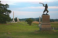
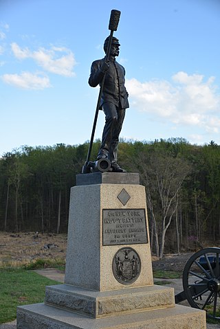
The practice of preserving the battlefields of the American Civil War for historical and memorial reasons has been developed over more than 150 years in the United States. Even during the American Civil War active duty soldiers on both sides of the conflict began erecting impromptu battlefield monuments to their recently fallen comrades. Since these initial attempts at preservation and commemoration, important Civil War battle sites have been preserved by various groups and many are now in the care of the National Park Service and overseen by the American Battlefield Protection Program (ABPP). Of approximately 10,500 acts of aggression that occurred between the United States and the Confederacy 384 have been identified in a 1993 federal report as being principle to the conflict. From these a select few have been chosen based on their historical significance, accessibility, and preservability to be federally curated. Beyond sites run by the U.S. Federal government many secondary battle sites across the United States are maintained and operated by state governments and private historical groups.
This page is based on this Wikipedia article Text is available under the CC BY-SA 4.0 license; additional terms may apply. Images, videos and audio are available under their respective licenses.