Antietam National Battlefield

Last updated

Antietam National Battlefield
Antietam Bloody Lane.JPG
Bloody Lane at Antietam
USA Maryland location map.svg
Red pog.svg
Usa edcp location map.svg
Red pog.svg
Location Washington County, Maryland, U.S.
Nearest city Sharpsburg, MD
Coordinates 39°28′13″N77°44′17″W / 39.47028°N 77.73806°W / 39.47028; -77.73806
Area3,229 acres (13.07 km2) [1]
EstablishedAugust 30, 1890 (1890-August-30) [2]
Visitors385,000(in 2011) [3]
Governing body National Park Service
Website Antietam National Battlefield
Antietam National Battlefield
LocationN of Sharpsburg off MD 45, Sharpsburg, Maryland
Built1862
NRHP reference No. 66000038 [4]
Added to NRHPOctober 15, 1966

Antietam National Battlefield is a National Park Service-protected area along Antietam Creek in Sharpsburg, Washington County, northwestern Maryland. It commemorates the American Civil War Battle of Antietam that occurred on September 17, 1862.

Contents

The area, situated on fields among the Appalachian foothills near the Potomac River, features the battlefield site and visitor center, a national military cemetery, stone arch Burnside's Bridge, and a field hospital museum.

Features

In the Battle of Antietam, General Robert E. Lee's first invasion of the North ended on this battlefield in 1862. [5] Established as Antietam National Battlefield Site August 30, 1890, [6] the park was transferred from the War Department on August 10, 1933, [7] and redesignated November 10, 1978. [6] Along with all historic areas administered by the National Park Service, the battlefield was listed on the National Register of Historic Places on October 15, 1966. [4] Additional documentation on the site was recorded by the National Park Service on February 27, 2009. [8]

Cemetery

Antietam National Cemetery, which adjoins the park, covers 11.36 acres (4.60 ha) and contains more than 4,976 interments (1,836 unidentified). [9] The cemetery was commissioned in 1865, and interments began in 1867, following an arduous process of identifying the remains, which was only successful in about 40% of the cases. [10] Civil War era burials in this cemetery consist of only Union soldiers; Confederate dead were interred in the Washington Confederate Cemetery in Hagerstown, Maryland; Mt. Olivet Cemetery, in Frederick, Maryland; and Elmwood Cemetery in Shepherdstown, West Virginia. [10] The cemetery also contains the graves of veterans and their wives from the Spanish–American War, both World Wars, and the Korean War. [9] The cemetery was closed to additional interments in 1953. [9] However, two exceptions have been made; the first in 1978 for Congressman Goodloe Byron and the second in 2000 for the remains of USN Fireman Patrick Howard Roy who was killed in the attack on the USS Cole. [9] The cemetery was placed under the War Department on July 14, 1870; [11] it was transferred to the National Park Service on August 10, 1933. [12] The gatehouse at the cemetery entrance was the first building designed by Paul J. Pelz, later architect of the Library of Congress.

Visitor Center

Signal tower, on Elk Mountain, overlooking the battlefield of Antietam. From the Liljenquist Family Collection of Civil War Photographs, Prints and Photographs Division, Library of Congress Signal tower, on Elk Mountain, overlooking battle-field of Antietam LCCN2016646117.jpg
Signal tower, on Elk Mountain, overlooking the battlefield of Antietam. From the Liljenquist Family Collection of Civil War Photographs, Prints and Photographs Division, Library of Congress

The Antietam National Battlefield Visitor Center contains museum exhibits about the battle and the Civil War. The Visitor Center was constructed in 1962 as part of the Mission 66 plan. A 26-minute orientation film narrated by James Earl Jones is shown on the hour and the half-hour. The visitor center is open seven days a week from 9:00 a.m. to 5:00 p.m., except on Thanksgiving, Christmas, and New Year's Day. Park rangers offer interpretive talks and an audio tour is available for purchase to accompany the self-guided 8.5-mile (13.7 km) driving tour of the battlefield with eleven stops. Park Grounds are open daylight hours. There is a park entrance fee of $10.00 per person (age 17 or older; 16 and under FREE) or $20.00 per vehicle. The entrance fee is valid for three days. [13]

Pry House Field Hospital Museum

The Pry House Field Hospital Museum is located in the house that served as Union Commander General George B. McClellan's headquarters during the battle. Exhibits focus on period medical care of the wounded, as well as information about the Pry House. The museum is sponsored by the National Museum of Civil War Medicine. [14]

Antietam Battlefield Illumination

This memorial illumination was started in 1989 and continues to this day on the first Saturday in December. Every year, over a thousand volunteers place 23,000 luminaries in rows on the northern portion of the battlefield. The luminaries consist of a paper bag filled with sand and a candle, and represents a soldier that was killed, injured, or went missing during the Battle of Antietam. [15]

Additional battlefield preservation

The Antietam National Battlefield was listed as one of America's Most Endangered Places in the years 1988, 1989, 1990, 1991, according to the National Trust for Historic Preservation. [16] The Battlefield was added to the list in response to a "...flawed proposal to construct a shopping center and other buildings on battlefield land, the listing helped to galvanize support and action by local, state and federal agencies and non-profit organizations." By 2017, the Antietam National Battlefield was deemed a success story and was included alongside ten other sites that previously named to the Most Endangered and also became the focus of successful preservation efforts. [17]

The American Battlefield Trust and its federal, state, and local partners, including the Save Historic Antietam Foundation, have acquired and preserved 468 acres (1.89 km2) of the overall battlefield through mid-2023, [18] including the "epicenter" tract, a 44.4-acre, previously privately owned parcel in the heart of the battlefield park between the Cornfield and the Dunker Church. The land, also known as the Wilson farm, was purchased by the Trust in 2015 for about $1 million. [19] The preservation organization has since removed the postwar house and barn that stood on the property along Hagerstown Pike and returned the land to its wartime appearance. [20]

Battle of Antietam

Morning phase

Dunker Church Antietam Dunker Church.JPG
Dunker Church

The Battle began at dawn on September 17, 1862, when Maj. Gen. Joseph Hooker began the Union artillery bombardment of the Confederate positions of Maj. Gen. Thomas J. "Stonewall" Jackson in the Miller cornfield. Hooker's troops advanced behind the falling shells and drove the Confederates from their positions. Around 7 a.m. Jackson reinforced his troops and pushed the Union troops back. Union Maj. Gen. Joseph K. Mansfield sent his men into the fray and regained some of the ground lost to the Confederates. [21]

Midday phase

Sunken Road. Antietam Sunken Road.JPG
Sunken Road.

As the fighting in the cornfield was coming to a close, Maj. Gen. William H. French was moving his Federals forward to support Maj. Gen. John Sedgwick and veered into Confederate Maj. Gen. D.H. Hill's troops posted in the Sunken Road. Fierce fighting continued here for four hours before the Union troops finally took the road. [21]

Afternoon phase

Burnside's Bridge Burnside's Bridge, Sharpsburg, MD.jpg
Burnside's Bridge

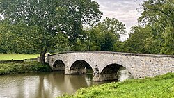
On the southeast side of town, Union Maj. Gen. Ambrose E. Burnside's XI Corps had been trying to cross Antietam Creek since mid-morning, being held up by only 500 Georgia sharpshooters. Around 1 p.m., they finally crossed Burnside's Bridge and took the heights. After a 2-hour lull to reform the Union lines, they advanced up the hill, driving the Confederates back towards Sharpsburg. But for the timely arrival of Maj. Gen. A.P. Hill's division from Harpers Ferry, Burnside would have entered Sharpsburg. Instead, the Union troops were driven back to the heights above the bridge. [21]

Conclusion

The battle was over with the Union sitting on three sides, waiting for the next day. During the night of the 18th, General Lee pulled his troops back across the Potomac River, leaving the battle and the town to General McClellan. It was the bloodiest day in United States history, with a combined tally of 22,717 dead, wounded, or missing. [22]

Related Research Articles

<span class="mw-page-title-main">Battle of Antietam</span> 1862 battle of the American Civil War

The Battle of Antietam, or Battle of Sharpsburg particularly in the Southern United States, was a battle of the American Civil War fought on September 17, 1862, between Confederate Gen. Robert E. Lee's Army of Northern Virginia and Union Gen. George B. McClellan's Army of the Potomac near Sharpsburg, Maryland, and Antietam Creek. Part of the Maryland Campaign, it was the first field army–level engagement in the Eastern Theater of the American Civil War to take place on Union soil. It remains the bloodiest day in American history, with a combined tally of 22,727 dead, wounded, or missing. Although the Union army suffered heavier casualties than the Confederates, the battle was a major turning point in the Union's favor.

<span class="mw-page-title-main">Sharpsburg, Maryland</span> Town in Maryland, United States

Sharpsburg is a town in Washington County, Maryland. The town is approximately 13 miles (21 km) south of Hagerstown. Its population was 705 at the 2010 census.

<span class="mw-page-title-main">Battle of South Mountain</span> Battle of the American Civil War

The Battle of South Mountain—known in several early Southern accounts as the Battle of Boonsboro Gap—was fought on September 14, 1862, as part of the Maryland campaign of the American Civil War. Three pitched battles were fought for possession of three South Mountain passes: Crampton's, Turner's, and Fox's Gaps. Maj. Gen. George B. McClellan, commanding the Union Army of the Potomac, needed to pass through these gaps in his pursuit of Confederate General Robert E. Lee's precariously divided Army of Northern Virginia. Although the delay bought at South Mountain would allow him to reunite his army and forestall defeat in detail, Lee considered termination of the Maryland Campaign at nightfall.

<span class="mw-page-title-main">Battle of Harpers Ferry</span> Battle of the American Civil War

<span class="mw-page-title-main">Battle of Shepherdstown</span> Battle of the American Civil War

The Battle of Shepherdstown, also known as the Battle of Boteler's Ford, took place September 19–20, 1862, at Boteler's Ford along the Potomac River, during the Maryland campaign of the American Civil War. After the Battle of Antietam on September 17, General Robert E. Lee and the Confederate Army of Northern Virginia withdrew across the Potomac. Lee left a rear guard commanded by Brigadier General William N. Pendleton at Boteler's Ford. On September 19, elements of the Union V Corps dueled with Pendleton's artillery before pushing a short distance across the river at dusk. Pendleton inaccurately informed Lee that all of the artillery of the rear guard had been captured. On the morning of September 20, the Confederates counterattacked with A. P. Hill's Light Division, forcing the Union units back across the Potomac. One Union unit, the 118th Pennsylvania Infantry Regiment, did not withdraw at the same time as the others and suffered heavy losses. Lee's army continued its retreat into the Shenandoah Valley after the battle.

<span class="mw-page-title-main">Battle of Williamsport</span> Battle of the American Civil War

The Battle of Williamsport, also known as the Battle of Hagerstown or Falling Waters, took place from July 6 to July 16, 1863, in Washington County, Maryland, as part of the Gettysburg Campaign of the American Civil War. It is not to be confused with the fighting at Hoke's Run which was also known as the Battle of Falling Waters.

<span class="mw-page-title-main">Maryland campaign</span> 1862 invasion of Northern United States

The Maryland campaign occurred September 4–20, 1862, during the American Civil War. Confederate Gen. Robert E. Lee's first invasion of the North was repulsed by the Army of the Potomac under Maj. Gen. George B. McClellan, who moved to intercept Lee and his Army of Northern Virginia and eventually attacked it near Sharpsburg, Maryland. The resulting Battle of Antietam was the bloodiest single-day battle in American history.

<span class="mw-page-title-main">Antietam Creek</span> Creek in Pennsylvania and Maryland, USA

Antietam Creek is a 41.7-mile-long (67.1 km) tributary of the Potomac River located in south central Pennsylvania and western Maryland in the United States, a region known as the Hagerstown Valley. The creek became famous as a focal point of the Battle of Antietam during the American Civil War.

<span class="mw-page-title-main">Fredericksburg and Spotsylvania National Military Park</span> American Civil War battlefields in Virginia

Fredericksburg and Spotsylvania National Military Park is a unit of the National Park Service in Fredericksburg, Virginia, and elsewhere in Spotsylvania County, commemorating four major battles in the American Civil War: Fredericksburg, Chancellorsville, The Wilderness, and Spotsylvania.

<span class="mw-page-title-main">Isaac P. Rodman</span> American politician

Isaac Peace Rodman was a Rhode Island banker, politician, and a Union Army brigadier general in the American Civil War, who became mortally wounded at the Battle of Antietam.

The Battle of Crampton's Gap, or Battle of Burkittsville, was a battle fought between forces under Confederate Brig. Gen. Howell Cobb and Union Maj. Gen. William B. Franklin as part of the Battle of South Mountain on September 14, 1862, at Crampton's Gap in Western Maryland, during the Maryland Campaign of the American Civil War.

The following Confederate States Army units and commanders fought in the Battle of Antietam of the American Civil War. The Union order of battle is listed separately. Order of battle compiled from the army organization during the campaign, the casualty returns and the reports.

<span class="mw-page-title-main">Gathland State Park</span> State park in Maryland, United States

Gathland State Park is a public recreation area and historic preserve located on South Mountain near Burkittsville, Maryland, in the United States. The state park occupies the former estate of war correspondent George Alfred Townsend (1841-1914), who wrote under the pen name "Gath" during the American Civil War. The estate's few remaining original structures include the War Correspondents Memorial Arch, which sits alongside the Appalachian Trail. The park is operated by the Maryland Department of Natural Resources. The arch is a National Historic Monument maintained by the National Park Service.

<span class="mw-page-title-main">Burnside's Bridge</span> Historic bridge in Maryland, United States

Burnside's Bridge is a landmark on the Civil War Antietam National Battlefield near Sharpsburg, northwestern Maryland.

<span class="mw-page-title-main">Maryland Route 34</span> State highway in Washington County, Maryland, US

Maryland Route 34 is a state highway in the U.S. state of Maryland. Known for most of its length as Shepherdstown Pike, the state highway begins at the West Virginia state line at the Potomac River, where the highway continues south as West Virginia Route 480 through Shepherdstown. The state highway runs 9.95 miles (16.01 km) east to U.S. Route 40 Alternate in Boonsboro. MD 34 is the main east–west highway of southern Washington County, connecting Shepherdstown and Boonsboro with Sharpsburg and Keedysville. The state highway, which was preceded by the Boonsboro and Sharpstown Turnpike, was constructed as a modern highway in the late 1910s and early 1920s. MD 34's bypass of Keedysville opened around 1960. The western end of the state highway has had three bridges. A 19th-century bridge was destroyed in a 1936 flood and replaced by the James Rumsey Bridge in 1939. The present bridge, also named for James Rumsey, opened in 2005.

<span class="mw-page-title-main">Maryland Route 65</span> State highway in Washington County, Maryland, US

Maryland Route 65 is a state highway in the U.S. state of Maryland. Known for most of its length as Sharpsburg Pike, the state highway runs 11.75 miles (18.91 km) from MD 34 in Sharpsburg north to the southern end of Hagerstown, where the highway continues north as Potomac Street toward the downtown area. MD 65 connects central and southern Washington County and serves as the primary access point to Antietam National Battlefield. The state highway, which was originally laid out as a turnpike, was constructed in its modern form in the mid-1920s. MD 65 was rebuilt in the early 1950s and relocated through Antietam National Battlefield by the early 1980s.

<span class="mw-page-title-main">Hoffman Farm</span> United States historic place

Hoffman Farm is a historic farm complex located at Keedysville, Washington County, Maryland, United States. It consists of an 1840s Greek Revival style two-story brick dwelling, adjacent brick slave quarters, a Federal-style stone house built about 1810 over a spring, a frame wagon shed, a log hog barn, and a frame forebay bank barn. The farm buildings were used as a hospital during the American Civil War in Battle of Antietam from the day of the battle on September 17, 1862, and through the following month. Over 800 men were hospitalized in the barn, house, outbuildings, and grounds.

<span class="mw-page-title-main">Mount Airy (Sharpsburg, Maryland)</span> Historic house in Maryland, United States

Mount Airy, also known as Grove Farm, is a historic home located at Sharpsburg, Washington County, Maryland, United States. It is a 2+12-story Flemish bond brick house, built about 1821 with elements of the Federal and Greek Revival styles. Also on the property are a probable 1820s one-story gable-roofed brick structure that has been extensively altered over time, a late-19th-century frame barn with metal roof ventilators, a 2-story frame tenant house built about 1900, and a mid-20th-century cinder block animal shed. It was used as a hospital for Confederate and Union soldiers following the Battle of Antietam. On October 3, 1862, President Abraham Lincoln and General George McClellan visited Mount Airy, an event recorded photographically by Alexander Gardner.

<span class="mw-page-title-main">Hagerstown, Maryland</span> City in Maryland, United States

Hagerstown is a city in and the county seat of Washington County, Maryland, United States. The population was 43,527 at the 2020 census. Hagerstown ranks as Maryland's sixth-largest incorporated city and is the largest city in the Maryland Panhandle.

<span class="mw-page-title-main">Washington Confederate Cemetery</span> Portion of the Rose Hill Cemetery in Washington County, Maryland, US

The Washington Confederate Cemetery is a Confederate Cemetery in Hagerstown, Maryland. Its burials include Confederate dead from such nearby battles as Antietam, Gettysburg, Monocacy and South Mountain. Less than 20 percent of its burials are identified. It was established in 1871 as a section of the Rose Hill Cemetery (Maryland).

References

External videos
Antietam National Battlefield Memorial - memorial 02.JPG
Nuvola apps kaboodle.svg Maryland Monument of the Battle of Antietam (4:33)] [23]

Notes

  1. "Listing of acreage – December 31, 2020" (XLSX). Land Resource Division, National Park Service. Retrieved August 15, 2021. (National Park Service Acreage Reports)
  2. "Park Anniversaries" . Retrieved August 13, 2021.
  3. "NPS Annual Recreation Visits Report". National Park Service. Retrieved March 30, 2012.
  4. 1 2 "National Register Information System". National Register of Historic Places . National Park Service. July 9, 2010.
  5. Tilberg, Frederick (1960). "Across the Potomac". Antietam National Battlefield Site Maryland Historical Handbook. National Park Service. Retrieved February 2, 2007.
  6. 1 2 "National Park System Birthdays". National Park Service History. National Park Service. April 13, 2006. Archived from the original on February 16, 2007. Retrieved February 2, 2007.
  7. Tilberg, Frederick (1960). "Antietam National Battlefield Site and Cemetery". Antietam National Battlefield Site Maryland Historical Handbook. National Park Service. Archived from the original on February 6, 2007. Retrieved February 2, 2007.
  8. "Weekly List of Actions Taken on Properties: 2/23/09 through 2/27/09". National Register of Historic Places. National Park Service. March 6, 2009.
  9. 1 2 3 4 "Antietam National Cemetery, part 2". Antietam National Battlefield. National Park Service. Retrieved September 4, 2015.
  10. 1 2 "Antietam National Cemetery". Antietam National Battlefield. National Park Service. Retrieved September 3, 2015.
  11. Lee, Ronald F. (1973). "III. The First Battlefield Parks,1890–1899". The Origin and Evolution of the National Military Park Idea. National Park Service. Archived from the original on February 13, 2007. Retrieved February 2, 2007.
  12. "1930's". NPS Chronological Timeline. National Park Service. May 19, 2006. Archived from the original on February 10, 2008. Retrieved February 2, 2007.
  13. "Plan Your Visit – Antietam National Battlefield (U.S. National Park Service)". www.nps.gov.
  14. "Pry House Field Hospital Museum". National Museum of Civil War Medicine.
  15. "The Antietam Battlefield Illumination: A Powerful Representation of the Battle's 23,110 Casualties". www.civilwar.com. Retrieved October 6, 2019.
  16. https://savingplaces.org/11most-past-listings#.XsK58El7ncs America's 11 Most Endangered Historic Places
  17. https://savingplaces.org/press-center/media-resources/historic-boston-theaters-named-to-list-of-americas-11-most-endangered-historic-places-success-stories#.XsK8XUl7ncs Historic Boston Theaters Named To List Of “America’s 11 Most Endangered Historic Places” Success Stories
  18. American Battlefield Trust "Antietam Battlefield" webpage. Accessed May 15, 2023.
  19. "Critical Piece of Antietam Battlefield Preserved," Hagerstown (Md.) Herald Mail, Sept. 30, 2015. Accessed Jan. 3, 2018.
  20. Antietam Rebirth Accessed Jan. 3, 2018.
  21. 1 2 3 Antietam National Battlefield, Maryland Brochure; National Park Service, U.S. Department of the Interior; Harpers Ferry Design Center, Harpers Ferry, WV
  22. McPherson, James M. (2002). Crossroads of Freedom: Antietam, The Battle That Changed the Course of the Civil War. New York: Oxford University Press. ISBN   0-19-513521-0.
  23. "Maryland Monument of the Battle of Antietam". C-SPAN. September 16, 2013. Retrieved March 16, 2013.