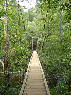
Wicomico Demonstration Forest is primarily forested land. This area is used by the Maryland Forest Service to demonstrate various timber management techniques and practices.
Six marked recreational trails (4 loops, 2 connecting) are offered, ranging from short hikes to longer day trips. Motorized vehicles are prohibited on trails, however hiking, horseback riding and bicycling are acceptable uses, trail conditions permitting.
Dark Blue Trail: 2.6-mile loop trail. A parking area for large vehicles is located at the head of the trial on Morris Road. A picnic area is located at the convergence of the loop trail approximately 0.6 miles from the parking area.
Green Trail: 1.0-mile loop trail around the arboretum. This trail shares a section with the White Trail.
Red Trail: 2.2-mile loop trail. This trail shares a section with the White Trail. Growing and mature pine and hardwood forests and a habitat restoration project with an early successional forest plan are the highlights of this trail.
White Trail: 6.1-mile loop trail. This trail shares some sections with the Green and Red Trails. As the longest marked loop trail, this trail features numerous pine stands and management regimes indicative of the Wicomico Demonstration Forest.
Light Blue Trail: 0.8-mile trail that parallels the northwestern portion of the White Trail between Sixty Foot Road and Seymore Road. Orange Trail: 0.7-mile trail that connects Shavox Road and the White Trail to the Light Blue Trail.
Parking for the Green, Red, and White trails is available at the Wicomico County Forestry Office on Sixty Foot Road. The parking area on Sixty Foot Road can accommodate large vehicles such as horse trailers. Additional parking for the Red, White, Light Blue, and Orange trails is available on Shavox Road, Seymore Road, and Powell Road.
The Red Rock Canyon National Conservation Area in Clark County, Nevada, is an area managed by the Bureau of Land Management as part of its National Landscape Conservation System, and protected as a National Conservation Area. It is about 15 miles (24 km) west of Las Vegas, and is easily seen from the Las Vegas Strip. More than two million people visit the area each year.
Eno River State Park is a 4,319-acre (17.48 km2) North Carolina state park in Durham and Orange Counties, North Carolina. Together with the adjoining West Point on the Eno city park, the two parks preserve over 14 miles (22.5 km) of the Eno River and surrounding lands.
William B. Umstead State Park is a North Carolina state park in Wake County, North Carolina in the United States. It covers 5,599 acres (22.66 km2) nestled between the expanding cities of Raleigh, Cary, and Durham, North Carolina. It offers hiking, bridle, and bike trails, boat rentals, camping, picnic areas, and educational programs.
The Conecuh National Forest in southern Alabama covers 83,000 acres (340 km2), along the Alabama - Florida line in Covington and Escambia counties. Topography is level to moderately sloping, broad ridges with stream terraces and broad floodplains.
Cleveland National Forest encompasses 460,000 acres, mostly of chaparral, with a few riparian areas. A warm dry mediterranean climate prevails over the forest. It is the southernmost U.S. National Forest of California. It is administered by the U.S. Forest Service, a government agency within the United States Department of Agriculture. It is divided into the Descanso, Palomar and Trabuco Ranger Districts and is located in the counties of San Diego, Riverside, and Orange.
Blue Knob State Park is a 6,128-acre (2,480 ha) Pennsylvania state park in Kimmel, Lincoln, and Pavia townships in Bedford County, Pennsylvania, in the United States. The average annual snowfall at the park is about 12 feet (370 cm). The park is named for Blue Knob, the second highest mountain in Pennsylvania at 3,146 feet (959 m). It is the location of Blue Knob All Seasons Resort, the ski slope in Pennsylvania with the highest elevation. Blue Knob State Park is just off Interstate 99 on Pennsylvania Route 869 west of Pavia.
Greenwood Furnace State Park is a 423-acre (171 ha) Pennsylvania state park in Jackson Township, Huntingdon County, Pennsylvania in the United States. The park is near the historic iron making center of Greenwood Furnace. The park includes the ghost town of Greenwood that grew up around the ironworks, old roads and charcoal hearths. Greenwood Furnace State Park is adjacent to Rothrock State Forest and on the western edge of an area of Central Pennsylvania known as the Seven Mountains. The park is on Pennsylvania Route 305, 20 miles (32 km) south of State College.
Sproul State Forest is a Pennsylvania state forest in Pennsylvania Bureau of Forestry District #10. The main offices are located in Renovo, Pennsylvania in Clinton County in the United States.
The Sam Houston National Forest, one of four National Forests in Texas, is located 50 miles north of Houston. The forest is administered together with the other three United States National Forests and two National Grasslands located entirely in Texas, from common offices in Lufkin, Texas. The units include Angelina, Davy Crockett, Sabine, and Sam Houston National Forests, plus Caddo National Grassland and Lyndon B. Johnson National Grassland. There are local ranger district offices located in New Waverly.
Joseph E. Ibberson Conservation Area is a 783-acre (317 ha) Pennsylvania state park in Middle Paxton and Wayne Townships, Dauphin County, Pennsylvania in the United States.
Coolidge State Park is a Vermont State Park located in Plymouth, Vermont, United States. The park is named after Calvin Coolidge, the 30th President of the United States, who was born and raised in Plymouth and is buried there as well. It is the primary recreational center for Calvin Coolidge State Forest, the largest state forest in Vermont. The park's facilities, built by the Civilian Conservation Corps (CCC) in the 1930s, are listed on the National Register of Historic Places.
The Lillinonah Trail is a 5.9-mile (9.5 km) Blue-Blazed hiking trail "system" in the lower Housatonic River valley in Fairfield County and, today, is entirely in Newtown. Most of the trail is in the upper block of Paugussett State Forest.
The 'Whitestone Cliffs Trail' is a 1.7-mile (2.7 km) Blue-Blazed hiking trail in the Waterbury area in Thomaston and Plymouth, Litchfield County, Connecticut. It is contained almost entirely in a section of the Mattatuck State Forest. The mainline trail is a loop trail with one connector trail to the Jericho Blue-Blazed Trail.
The Black Forest Trail is a 42-mile (68 km) loop trail in Pennsylvania's Tiadaghton State Forest in parts of Lycoming, Potter, and Clinton Counties. A number of other forest roads, hiking, and cross country ski trails cross the Black Forest Trail making it possible to do shorter loops for day hikes or shorter backpacking trips. The Black Forest Trail is known for its steep ascents and descents and views of the Pine Creek Gorge and other canyons to the west.
The Foot Hills State Forest is a state forest located in Cass, and Hubbard counties, Minnesota. The forest is a popular recreation spot due to its proximity to the greater Minneapolis – Saint Paul metropolitan area.
The Pachaug Trail is a 28-mile (45 km) Connecticut hiking trail and is one of the Blue-Blazed hiking trails maintained by the Connecticut Forest and Park Association. It is a horseshoe shaped trail.
The Narragansett Trail is a 16-mile (26 km) Connecticut hiking trail and is one of the Blue-Blazed hiking trails maintained by the Connecticut Forest and Park Association and the Narragansett Council, the Rhode Island chapter of the Boy Scouts of America.
The Quebec Run Trail System consists of six maintained hiking trails totaling 23.2 miles (37.3 km) and marked with 2-by-6-inch blue blazes, as well as many unmarked logging roads and trails for those wishing to get off the beaten path. The trails are contained in the Quebec Run Wild Area, a heavily forested section of land along the eastern slope of Chestnut Ridge in Fayette County. A short distance north of the Pennsylvania–West Virginia border, the area consists of 7,441 acres (3,011 ha) that encompass almost all of the Quebec Run and Tebolt Run watersheds.
The Chatfield Trail is a 4.7-mile Blue-Blazed hiking trail located within the town of Killingworth, Connecticut.
Elliott Corbett Memorial State Recreation Site is a state park along the south shore of Blue Lake Crater in Jefferson County, Oregon, United States. The park is named in honor of Elliott R. Corbett II, who was killed while serving in the United States Army during World War II. It includes 63 acres (25 ha) of wilderness land with very few park facilities. Corbett State Park is administered by the Oregon Parks and Recreation Department.
This page is based on this Wikipedia article Text is available under the CC BY-SA 4.0 license; additional terms may apply. Images, videos and audio are available under their respective licenses.