Deep Creek Lake State Park is a public recreation area occupying more than 1,100 acres (450 ha) on the northeast side of Deep Creek Lake in Garrett County, Maryland, in the United States. The park features water activities, camping facilities, and recreational trails and is located about 18 miles (29 km) south of Interstate 68 on U.S. Route 219.

Seneca Creek State Park is a public recreation area encompassing more than 6,300 acres (2,500 ha) along 14 miles of Seneca Creek in its run to the Potomac River in Montgomery County, Maryland. The park features facilities for boating and fishing as well as trails for hiking, cycling, and horseback riding. It is managed by the Maryland Department of Natural Resources.

Tiadaghton State Forest is a Pennsylvania State Forest in the Pennsylvania Department of Conservation and Natural Resources, Bureau of Forestry. The forest is primarily in western and southern Lycoming County, with small portions in Clinton, Potter, Tioga, and Union Counties. The district's topography consists of narrow, flat to sloping plateaus cut by deep, steep-sloped valleys carved by fast moving mountain streams, including Pine Creek, Slate Run, and their tributaries. The Tiadaghton district extends south across the lowland along the west branch of the Susquehanna River to the narrow crests of Bald Eagle Mountain and North and South White Deer Ridge. The majority of forest cover is dominated by mixed oak forests, with some areas of northern hardwoods. The Tiadaghton State Forest is one of eight forest districts in the Pennsylvania Wilds region.

Swallow Falls State Park is a public recreation area located on the west bank of the Youghiogheny River nine miles (14 km) northwest of Oakland in Garrett County, Maryland, in the United States. The state park features Maryland's highest free-falling waterfall, the 53-foot (16 m) Muddy Creek Falls, as well as smaller waterfalls on the Youghiogheny River and Tolivar Creek. The park is notable for its stand of old hemlock trees, some more than 300 years old, "the last stand of its kind in Maryland."

Upper Pine Bottom State Park is a 5-acre (2.0 ha) Pennsylvania state park in Lycoming County, Pennsylvania in the United States. The park is in Cummings Township on Pennsylvania Route 44 and is surrounded by the Tiadaghton State Forest. It is on Upper Pine Bottom Run, which gave the park its name and is a tributary of Pine Creek. Upper Pine Bottom State Park is in the Pine Creek Gorge, where the streams have cut through five major rock formations from the Devonian and Carboniferous periods.

Susquehanna State Park is a public recreation area located on the banks of the lower Susquehanna River north of the city of Havre de Grace, Maryland. The state park's main area is on the west bank of the river; the park also manages land on the river islands and east bank. The park offers fishing, boating, camping, and trails for hiking and equestrian use. It is managed as a complex with Rocks State Park and Palmer State Park by the Maryland Department of Natural Resources.

White Clay Creek Preserve is a 3,050-acre (1,230 ha) Pennsylvania state park along the valley of White Clay Creek in London Britain Township in Chester County, Pennsylvania in the United States. The park was donated by the DuPont Company in 1984 for the purpose of "preserving the diverse and unique plant and animal species, and the rich cultural heritage of the area". Dupont also donated an additional 528 acres (214 ha) for the adjoining White Clay Creek State Park to the state of Delaware. White Clay Creek Preserve is 3 miles (4.8 km) north of Newark, Delaware on Pennsylvania Route 896.
Deer Creek is a 52.9-mile-long (85.1 km) river in Maryland and Pennsylvania that flows through the scenic areas of Harford County and empties into the Susquehanna River, roughly halfway between the Interstate 95 bridge and Conowingo Dam. Its watershed area is 171 square miles (440 km2). Its watershed area in MD is 145 square miles (380 km2), with 3% impervious surface in 1994. It serves as a divider between the agricultural and urban/suburban areas of Harford County.
Herrington Manor State Park is a public recreation area on 365 acres (148 ha) in Garrett County, Maryland. The focal point of the state park is 53-acre (21 ha) Herrington Lake. The park lies adjacent to Swallow Falls State Park, approximately four miles (6.4 km) north of Oakland. Both parks are managed by the Maryland Department of Natural Resources.

Cunningham Falls State Park is a public recreation area located west of Thurmont, Maryland, in the United States. The state park is the home of Cunningham Falls, the largest cascading waterfall in Maryland, a 43-acre (17 ha) man-made lake, and the remains of a historic iron furnace. The park is one of several protected areas occupying 50-mile-long Catoctin Mountain; it is bordered on its north by Catoctin Mountain Park and on its south by Frederick Municipal Forest.
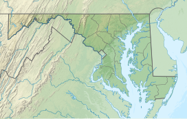
The Maryland Department of Natural Resources (DNR) is a government agency in the state of Maryland charged with maintaining natural resources including state parks, public lands, state forests, state waterways, wildlife, and recreation areas. Its headquarters are in Annapolis.

Rocks State Park is a public recreation area located in and around Deer Creek Valley near Pylesville, Harford County, Maryland. The state park's 1,060 acres (430 ha) preserve the geologic formation known as the King and Queen's Seat and other features in three non-contiguous areas near the junction of Maryland Route 24 and Maryland Route 165. It is managed by the Maryland Department of Natural Resources.
Gunpowder Falls State Park is a public recreation area comprising six non-contiguous areas covering 18,000 acres (7,300 ha) in northeastern Baltimore County and western Harford County, Maryland. The state park is primarily made up of the stream valleys of the Big and Little Gunpowder Falls and the Gunpowder River; its natural features range from tidal marshes to rugged interior slopes. The park has over 120 miles of trails for hiking, biking, horseback riding, and cross-country skiing plus facilities for picnicking, tubing, canoeing and kayaking, tide-water fishing and crabbing, fly fishing, and hunting, among other activities. It is managed by the Maryland Department of Natural Resources.

Greenbrier State Park is a public recreation area located on South Mountain, three miles (4.8 km) northeast of Boonsboro in Washington County, Maryland, USA. The state park has camping, hiking trails, and a 42-acre (17 ha) man-made lake. It is managed by the Maryland Department of Natural Resources.
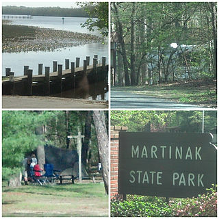
Martinak State Park is a public recreation area located on the Choptank River and Watts Creek, immediately south of Denton in Caroline County, Maryland. The park bears the name of George Martinak, who deeded his land to the state in 1961. The park opened in 1964. Site improvements including the addition of campsites, roads, and park office took place from 1964 to 1974. The park features boating access, fishing, campsites and cabins, hiking trails, a nature center, and painted rocks.

Smallwood State Park is a public recreation and historic preservation area located on Mattawoman Creek near Marbury, Charles County, Maryland. The state park preserves Smallwood's Retreat, the plantation home of former Continental Army officer and Governor of Maryland, Major General William Smallwood. The park's 984 acres (398 ha) include a marina, boat ramps, picnicking facilities, campsites, cabins, trails, and nature center.

South Mountain State Park is a public recreation area that runs for nearly the entire length of South Mountain through Washington and Frederick counties in Maryland. The state park is contiguous with several other national, state and local parks on the mountain, including the Chesapeake and Ohio Canal National Historical Park, Gathland State Park, Washington Monument State Park, Greenbrier State Park and Pen Mar County Park.

Tuckahoe State Park is a public recreation area along Tuckahoe Creek in Caroline and Queen Anne's counties on the Eastern Shore of Maryland, United States. Adkins Arboretum, a garden and preserve maintaining over 600 native plant species, occupies 500 acres of the park. The arboretum provides classes to the public in horticulture, ecology and natural history.
Knob Noster State Park is a public recreation area covering 3,934 acres (1,592 ha) in Johnson County, Missouri, in the United States. The state park bears the name of the nearby town of Knob Noster, which itself is named for one of two small hills or "knobs" that rise up in an otherwise flat section of Missouri. Noster is a Latin adjective meaning "our"—therefore, Knob Noster translates as "our hill." A local Indian belief stated that the hills were "raised up as monuments to slain warriors." The park offers year-round camping, hiking, and fishing and is managed by the Missouri Department of Natural Resources.

Matthew Henson State Park is a publicly owned greenway with recreational features that runs along Turkey Branch, a tributary of Rock Creek, in Montgomery County, Maryland. The state park is managed by Montgomery County under an agreement with the Maryland Department of Natural Resources. It was named for Maryland native and arctic explorer Matthew Henson.