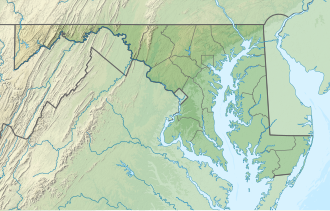
Patuxent River State Park | |
---|---|
Location | Howard County & Montgomery County, Maryland, United States |
Nearest town | Olney, Maryland |
Coordinates | 39°15′34″N77°04′53″W / 39.25944°N 77.08139°W Coordinates: 39°15′34″N77°04′53″W / 39.25944°N 77.08139°W [1] |
Area | 6,703 acres (27.13 km2) [2] |
Elevation | 407 ft (124 m) [1] |
Designation | Maryland state park |
Established | 1963 |
Administrator | Maryland Department of Natural Resources |
Website | Patuxent River State Park |
Patuxent River State Park is a public recreation area located along the upper reaches of the Patuxent River in Howard and Montgomery counties in Maryland. The state park features hunting, fishing, mountain biking, horseback riding, and hiking on unsigned and untended trails. [3] Planning for the park began in 1963, [4] with the Maryland General Assembly funding land purchases in each year from 1964 to 1968. [5] It is part of the Northeastern coastal forests ecoregion. [6]
Anne Arundel County, also notated as AA or A.A. County, is located in the U.S. state of Maryland. As of the 2020 United States census, its population was 588,261, an increase of just under 10% since 2010. Its county seat is Annapolis, which is also the capital of the state. The county is named for Lady Anne Arundell (1615–1649), a member of the ancient family of Arundells in Cornwall, England, and the wife of Cecilius Calvert, 2nd Baron Baltimore (1605–1675), founder and first lord proprietor of the colony Province of Maryland.
Brookeville is a town in Montgomery County, Maryland, United States, located 20 km (12 mi) north of Washington, D.C., and 2 km (1.2 mi) north of Olney. Brookeville was settled by Quakers late in the 18th century and was formally incorporated as a town in 1808. Historically part of the local agricultural industry, since the 1950s Brookeville has developed rapidly into a suburban community of Washington, D.C. following the construction of the Georgia Avenue toll road. The population was 134 at the 2010 census.
The Patuxent River is a tributary of the Chesapeake Bay in the state of Maryland. There are three main river drainages for central Maryland: the Potomac River to the west passing through Washington, D.C., the Patapsco River to the northeast passing through Baltimore, and the Patuxent River between the two. The 908-square-mile (2,352 km2) Patuxent watershed had a rapidly growing population of 590,769 in 2000. It is the largest and longest river entirely within Maryland, and its watershed is the largest completely within the state.
Calvert Cliffs State Park is a public recreation area in Lusby, Calvert County, Maryland, that protects a portion of cliffs that extend for 24 miles along the eastern flank of the Calvert Peninsula on the west side of Chesapeake Bay from Chesapeake Beach southward to Drum Point. The state park is known for the abundance of mainly Middle Miocene sub-epoch fossils that can be found on the shoreline.
Seneca Creek State Park is a public recreation area encompassing more than 6,300 acres (2,500 ha) along 14 miles of Seneca Creek in its run to the Potomac River in Montgomery County, Maryland. The park features facilities for boating and fishing as well as trails for hiking, cycling, and horseback riding. It is managed by the Maryland Department of Natural Resources.
Forbes State Forest is a Pennsylvania state forest in Pennsylvania Bureau of Forestry District #4. The main offices are located in Laughlintown in Westmoreland County, Pennsylvania in the United States. Mount Davis, the highest peak in Pennsylvania, is located in the forest.
Ohiopyle State Park is a Pennsylvania state park on 19,052 acres (7,710 ha) in Dunbar, Henry Clay and Stewart Townships, Fayette County, Pennsylvania in the United States. The focal point of the park is the more than 14 miles (23 km) of the Youghiogheny River Gorge that passes through the park. The river provides some of the best whitewater boating in the Eastern United States. Ohiopyle State Park is bisected by Pennsylvania Route 381 south of the Pennsylvania Turnpike. The park opened to the public in 1965, but was not officially dedicated until 1971.
Hillman State Park is a 3,600-acre (1,457 ha) Pennsylvania state park in Hanover Township, Washington County in the United States. It is about 25 miles (40 km) west of Pittsburgh. The park opened in the late 1960s and has been managed for hunting by the Pennsylvania Game Commission since the early 1980s. The park also has hiking, cross-country skiing, horseback riding, a radio-controlled aircraft field, and mountain bike trails that are open to the public. The largely undeveloped park is north of U.S. Route 22 and east of Pennsylvania Route 18 in northern Washington County near the village of Bavington and the borough of Burgettstown. Part of the park has been designated as Pennsylvania State Game Lands 117.
Dans Mountain State Park is a public recreation area located nine miles (14 km) south of Frostburg and to the east of the town of Lonaconing in Allegany County, Maryland. The state park occupies 482 acres (195 ha) on 16-mile-long (26 km) Dans Mountain and is managed by the Maryland Department of Natural Resources.
Queen Anne in Prince George's County, Maryland, United States, is a former seaport on the Patuxent River. It was delineated as a CDP for the 2010 census, at which time it had a population of 1,280.
Elk Neck State Park is a public recreation area located between Chesapeake Bay and the Elk River near the southern tip of the Elk Neck Peninsula in Cecil County, Maryland. The state park is home to the historic Turkey Point Light and offers land-based and water-based recreation. The park is located on MD 272, eight miles (13 km) south of the town of North East, and 13 miles (21 km) south of exit 100 on I-95. It is operated by the Maryland Department of Natural Resources.
Hawlings River is a 12.9-mile-long (20.8 km) tributary of the Patuxent River in Montgomery County, Maryland. The watershed covers an area of about 28 square miles (73 km2). The waterway was originally called Holland's River. The headwaters of the river originate in the area north of Laytonsville, and the river flows southeast, entering the Patuxent about 1.5 miles (2.4 km) below the Triadelphia Reservoir. Portions of Hawlings River flow through Rachel Carson Conservation Park and Hawlings River Stream Valley Park. Tributaries of the Hawlings River include Mount Zion Tributary, Reddy Branch, Olney Mill Tributary, Gregg Tributary, and James Creek. The river and its tributaries total about 98 miles (158 km) of streams.
Greenbrier State Park is a public recreation area located on South Mountain, three miles (4.8 km) northeast of Boonsboro in Washington County, Maryland, USA. The state park has camping, hiking trails, and a 42-acre (17 ha) man-made lake. It is managed by the Maryland Department of Natural Resources.
Greenwell State Park is a public recreation area located on the Patuxent River in St. Mary's County, Maryland. The state park features the historic Rosedale Manor House as well as the Bonds-Simms tobacco barns complex. Park activities include hiking, cycling, horseback riding, fishing, picnicking, hunting, swimming, and canoeing.
Janes Island State Park is a public recreation area on Chesapeake Bay lying adjacent to the city of Crisfield in Somerset County, Maryland. The state park features some 30 miles (48 km) of marked water trails through the island's salt marsh leading to isolated pristine beaches. The park is managed by the Maryland Department of Natural Resources.
Martinak State Park is a public recreation area located on the Choptank River and Watts Creek, immediately south of Denton in Caroline County, Maryland. The park bears the name of George Martinak, who deeded his land to the state in 1961. The park opened in 1964. Site improvements including the addition of campsites, roads, and park office took place from 1964 to 1974. The park features boating access, fishing, campsites and cabins, hiking trails, a nature center, and painted rocks.
Maryland Wildlands are a group of public properties that are protected from logging or other activities in the state of Maryland.
Collington Branch is a stream that flows into the Western Branch of the Patuxent River in Prince George's County, Maryland.
The Green Branch of the Patuxent River in Prince George's County, Maryland is part of the Upper Patuxent Watershead. The stream passes centrally through the Governor Bridge Natural Area / Patuxent River Park and joins the Patuxent, just south of Governor's Bridge.
Wikimedia Commons has media related to Patuxent River State Park . |