Related Research Articles

Garrett County is the westernmost county of the U.S. state of Maryland. As of the 2020 census, the population was 28,806, making it the third-least populous county in Maryland. Its county seat is Oakland. The county was named for John Work Garrett (1820–1884), president of the Baltimore and Ohio Railroad. Created from Allegany County, Maryland in 1872, it was the last Maryland county to be formed.

Owings Mills is an unincorporated community and census-designated place in Baltimore County, Maryland, United States. It is a suburb of Baltimore. Per the 2020 census, the population was 35,674. Owings Mills is home to the northern terminus of the Baltimore Metro Subway, and housed the Owings Mills Mall until its closure in 2015. It is also home to the Baltimore Ravens' headquarters facility, and the studios for Maryland Public Television. In 2008, CNNMoney.com named Owings Mills number 49 of the "100 Best Places to Live and Launch".

Soldiers Delight Natural Environmental Area is a nature reserve near Owings Mills in western Baltimore County, Maryland, U.S. The site is designated both as a Maryland Wildland and as a Natural Environment Area and is part of the Maryland Wildlands Preservation System. The site's protected status is due to the presence of serpentine soil and over 39 rare, threatened, or endangered plant species along with rare insects, rocks and minerals.
Cedonia is a region of Northeastern Baltimore, Maryland consisting of the neighborhoods of Cedmont, Cedonia, and Frankford. It is located east of Belair Road, above Herring Run Park, and west of the Baltimore City/County Line. It is a predominantly residential area with neighborhoods that range from middle class to lower income.
The Baltimore City District Courthouses of the District Court of Maryland are located at North Avenue, Wabash Avenue, Patapsco Avenue and E. Fayette Street in Baltimore, Maryland, and serve as the courts of first impression for the majority of residents in Baltimore City.

Hillen is a small community just west of Hillen Road and Morgan State University and south of Coldspring Lane in Baltimore, Maryland, United States.
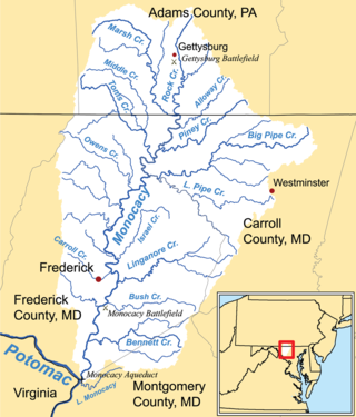
Linganore Creek is a 13.5-mile-long (21.7 km) tributary of the Monocacy River in Frederick County, Maryland. The stream is formed from the confluence of the north and south forks of the Linganore, about 10 miles (16 km) east-northeast of the city of Frederick. The creek runs roughly southwest to the Monocacy River, which drains to the Potomac River. The watershed area of the creek is 83.1 square miles (215 km2). High water in the creek can result in flooding of Gas House Pike, an east–west road running between Monocacy Boulevard and Green Valley Road.

A Natural Environment Area (NEA) is a unit of the Park Service of the Maryland Department of Natural Resources. These public lands are generally 1,000 acres (4 km2) or more in extent and are judged to constitute a "significant natural attraction or unique geological feature". Development within an NEA is generally confined to trails, interpretive facilities and limited support facilities.
Tuscarora Creek is a 7.7-mile-long (12.4 km) tributary of the Monocacy River in Frederick County, Maryland, in the United States.
Winters Run is a 14.6-mile-long (23.5 km) river in Harford County, Maryland. The river begins north of the community of Fallston at the confluence of the West and East Branches, and flows southeast about 11 miles (18 km) to Atkisson Dam in Bel Air. The dam and reservoir were built by the U.S. Army in 1942 to provide an auxiliary fresh water source for nearby Edgewood Arsenal. Upon reaching the tidal line, the river is renamed Otter Point Creek, which empties to Bush River and the Chesapeake Bay. The watershed area of Winters Run is about 56 square miles (150 km2).
Middle River is an estuary in Baltimore County, Maryland, located about 5 miles (8 km) east of the city of Baltimore. The estuary extends from the community of Middle River, north of the Martin Plaza Shopping Center, to the southeast for about 4 miles (6.4 km), to the Chesapeake Bay. The watershed area of Middle River is 12 square miles (31 km2), and includes Martin State Airport.

Gwynns Falls is a 24.9-mile-long (40.1 km) stream located in Baltimore County and Baltimore City, Maryland. Its headwaters are located in Reisterstown in Baltimore County, and the stream flows southeast, entering the city of Baltimore and emptying into the Middle Branch of the Patapsco River. The Patapsco drains into the Chesapeake Bay. The watershed area of Gwynns Falls covers 66 square miles (170 km2), with 133 miles (214 km) of streams.
Morgan Park is a neighborhood in Baltimore, Maryland, located immediately east of Morgan State University.
Piney Run Park is a nature park in Sykesville, located in Carroll County, Maryland. It is Carroll County's oldest developed park and hosts thousands of visitors annually. The park encompasses 550 acres of fields, forest and open spaces, features over 15 miles of hiking trails, a 300-acre lake and many sports and recreational facilities. Prior to being a park, this land was a private farm.
Deep Run is an 11.9-mile-long (19.2 km) tributary of the Patapsco River in central Maryland in the United States. The main stem arises in the vicinity of Ellicott City, starting in the Montgomery Meadows housing development, and the lower course forms part of the border between Howard and Anne Arundel Counties. It passes underneath Route 100 twice, Interstate 95 once, and Route 1 once as well.
The David Force Natural Resource Area is a 221-acre (89 ha) wildlife area in Ellicott City, Maryland. It is located between Route 70 and 40 adjacent to the Turf Valley development in Howard County, Maryland, and operated by the Howard County Department of Recreation and Parks.

Loyola-Notre Dame is a neighborhood located in Baltimore, Maryland. The neighborhood is named after the two universities that occupy most of the area: Notre Dame of Maryland University and Loyola University Maryland. The neighborhood is also home to the Evergreen House owned by Johns Hopkins University. The neighborhood covers all the area owned by the two universities and Evergreen House. The neighborhood does not cover a uniform area, but does have a relative definition. The northern boundary is Homeland Avenue. The eastern boundary varies among Millbrook Road, Underwood Road and other small streets. The Radnor Village, Thomas Aquinas Hall, and Loyola Public system are also included in the neighborhood despite being separated from the rest of the Loyola campus by the Radnor-Winston and Villages of Homeland neighborhoods. The southern border is Cold Spring Lane and the western border is primarily North Charles Street. Loyola extends via a pedestrian bridge over North Charles Street along Cold Spring Lane to Stony Run stream. The Loyola Fitness and Aquatics center is also across North Charles Street. The neighborhood is unique in having a very small permanent population, but housing over 4,000 students.
Taylorsville is an unincorporated place in Carroll County, Maryland, United States. Taylorsville is located where MD 26 and MD 27 intersect, approximately 17 miles east of Frederick and 27 miles northwest of Baltimore. Taylorsville is near Morgan Run Natural Environment Area.
Stony Run is a tributary stream of Jones Falls in Baltimore, Maryland. The stream headwaters are in north Baltimore near the city boundary. The stream flows southward about 3 miles (4.8 km) through several park areas - including Friends School of Batimore-and the neighborhood of Wyman Park, and enters a culvert before emptying into Jones Falls near Druid Hill Park.
The Rock Springs Generation Facility is a 684 MW natural gas-fired electric generating peaking plant located in Rising Sun, Maryland. The plant comprises four gas turbines and went online in 2003. The plant was originally co-owned by Old Dominion Electric Cooperative and Consolidated Edison, and was sold to AllCapital and Industry Funds Management in 2007. The Carlyle Group, an asset management company, acquired the plant in 2016.
References
- ↑ Wilson, Emily (July 29, 2016). Fiscal Year 2016 DNR Owned Lands Acreage (PDF) (Report). Maryland Department of Natural Resources. pp. 10–11. Retrieved February 27, 2017.