
The snow goose is a species of goose native to North America. Both white and dark morphs exist, the latter often known as blue goose. Its name derives from the typically white plumage. The species was previously placed in the genus Chen, but is now typically included in the "gray goose" genus Anser.

The Arapaho National Wildlife Refuge is a United States National Wildlife Refuge located in north-central Colorado. It is one of over 560 national wildlife refuges which manages and protects natural resources for future generations. The refuge is located in North Park in central Jackson County south of the town of Walden. The refuge was established in 1967 to furnish waterfowl with a suitable place to nest and rear their young. It was created in part to offset losses of nesting habitat in the prairie wetland region of the Midwest. It is located in the valley of the Illinois River, a tributary of the North Platte River. It is administered by the United States Fish and Wildlife Service.

The Atlantic Flyway is a major north-south flyway for migratory birds in North America. The route generally starts in Greenland, then follows the Atlantic coast of Canada, then south down the Atlantic Coast of the United States to the tropical areas of South America and the Caribbean. Every year, migratory birds travel up and down this route following food sources, heading to breeding grounds, or traveling to overwintering sites.

Baskett Slough National Wildlife Refuge is in northwestern Oregon, 10 miles (16 km) west of Salem in Polk County. The Refuge consists of 1,173 acres (4.75 km²) of cropland, which provide forage for wintering geese, 300 acres (1.2 km²) of forests, 550 acres (2.2 km²) of grasslands, and 500 acres (2.0 km²) of shallow water seasonal wetlands and 35 acres (0.14 km²) of permanent open water. In 1965, Baskett Slough National Wildlife Refuge was created to help ensure some of the original habitat remained for species preservation. The refuge is managed by the U.S. Fish and Wildlife Service, an agency of the U.S. Department of the Interior.

Hog Island is an uninhabited island located off the eastern shore of Washington Island in the town of Washington, Door County, Wisconsin, United States. The island has a land area of 2.14 acres (8,656 m2) and an elevation of 10 feet or 20 feet above Lake Michigan.

Oak Hammock Marsh is a marsh and a wildlife management area located 34 kilometres (21 mi) north of Winnipeg, Manitoba, Canada. The WMA is considered to be a Class IV protected area under the IUCN protected area management categories. The marsh is recognized as an Important Bird Area (IBA) for its globally significant numbers of waterfowl and shorebirds. It is a designated Ramsar site due to its international importance as a breeding and staging area for waterfowl and other migratory birds. It is 3,578.47 hectares in size.
E.A. Vaughn Wildlife Management Area is a state wildlife management area (WMA) of Maryland that consists of two separate parcels of land on Chincoteague Bay in Worcester County, between the villages of Girdletree and Stockton.
Isle of Wight Wildlife Management Area is a state wildlife management area (WMA) of Maryland located on the Isle of Wight, a small peninsula between the St. Martin's River and Isle of Wight Bay in Worcester County. Although called Isle of Wight, a small strip of marsh and road connects it with the mainland.
Oso Bay is a bay bordered by Corpus Christi, Texas. The bay is fed freshwater by Oso Creek and saltwater from Corpus Christi Bay. The Hans and Pat Suter Wildlife Refuge is located on the bay's western shore near the Pharaoh Valley subdivision, Naval Air Station Corpus Christi is located on its eastern shore in Flour Bluff, newly created Skimmer Key is located between the Oso Bay Bridge and the Naval Air Station, and Texas A&M University - Corpus Christi on Ward Island is located on the northern shore of Oso Bay. On the bay’s southwestern shore is the Oso Bay Wetlands Preserve.
The Brazoria National Wildlife Refuge is a 44,414-acre (179.74 km2) wildlife conservation area along the coast of Texas (USA), east of the towns of Angleton and Lake Jackson, Texas. It borders Christmas Bay and the Intracoastal Waterway, separated from the Gulf of Mexico by Follet's Island.

Kirkland Island, also known as Rose-Kirkland Island, is located within the municipality of Richmond, British Columbia and is part of a small alluvial archipelago known as the South Arm Marshes located within the Ladner Reach of the South Arm of the Fraser River in British Columbia, Canada. It is the northernmost island of the group and lies between Richmond on Lulu Island in the north and Delta and Ladner town centre in the south.

Glenn Martin National Wildlife Refuge includes the northern half of Smith Island, which lies 11 miles (18 km) west of Crisfield, Maryland, and Watts Island, which is located between the eastern shore of Virginia and Tangier Island. Both islands are situated in the lower Chesapeake Bay.

Located in Coos County, New Hampshire and Oxford County, Maine, Umbagog National Wildlife Refuge is a northern treasure in the National Wildlife Refuge System. The diversity of exceptional habitats provides excellent breeding and foraging areas for migratory birds, endangered species, resident wildlife, and rare plants. The refuge protects over 25,650 acres (103.8 km2) of wetland and forested upland habitat along Umbagog Lake. About 70% of its area is in New Hampshire and 30% in Maine.

Hagerman National Wildlife Refuge (HNWR), a haven for migratory birds and other wildlife, lies in northwestern Grayson County, Texas, on the Big Mineral Arm of Lake Texoma, on the Red River between Oklahoma and Texas. This National Wildlife Refuge is made up of water, marsh, and upland habitat. Visitors can hike, observe wildlife, hunt, and fish throughout the year.

Humboldt Bay National Wildlife Refuge is located on Humboldt Bay, on the California North Coast near the cities of Eureka and Arcata. The refuge exists primarily to protect and enhance wetland habitats for migratory water birds using the bay area, including tens of thousands of shorebirds, ducks, geese, swans, and the black brant. Humboldt Bay National Wildlife Refuge, along with other public and private lands around Humboldt Bay, is one of the key stopovers for the millions of migratory birds that rely on the Pacific Flyway. More than 200 bird species, including 80 kinds of water birds and four endangered species, regularly feed, rest, or nest on the refuge or other areas around the bay.
Pass a Loutre Wildlife Management Area (WMA) is a 66,000-acre (270 km2) protected wetland in Plaquemines Parish, Louisiana, United States. The WMA is located due south and bordering the 48,000 acre Delta National Wildlife Refuge, accessible only by air or boat, contains the Pass A L'Outre Lighthouse, and Port Eads is within the boundary.
The Wisconsin Islands Wilderness is a 29-acre (12 ha) wilderness area located in Door County in northeastern Wisconsin. It is one of the smallest wilderness areas in the United States. Managed by the U.S. Fish & Wildlife Service, the wilderness area is composed of three islands in Lake Michigan.
Whitewater Lake is a lake in the Canadian province of Manitoba located between Boissevain and Deloraine. It is an endorheic basin and more marsh than lake. Whitewater Lake was previously called White Lake due to the color of the salt flats exposed during dry periods. Whitewater Lake covers approximately 22,000 acres on average and only reaches depths of about 2 metres (6.6 ft). The lake is fed by several small streams which flow into it from the Turtle Mountains but has no natural outflow.
Dewey W. Wills Wildlife Management Area, also just called Dewey Wills Wildlife Management Area and formally known as the Saline Wildlife Management area, is a 63,901-acre tract of protected area located in LaSalle Parish, Catahoula Parish, and Rapides parish, in Central Louisiana. The Louisiana Department of Wildlife and Fisheries (LDWF) owns 63,901 acres, the LaSalle Parish School Board owns 1530 acres, and the U.S. Army Corps of Engineers (USCOE) owns 265 acres, managed by the LDWF.
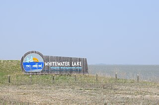
Topaz Slough Wildlife Management Area or Topaz Marsh is a marsh system that is part of the old Sevier River bed.