The Pocomoke River stretches approximately 66 miles (106 km) from southern Delaware through southeastern Maryland in the United States. At its mouth, the river is essentially an arm of Chesapeake Bay, whereas the upper river flows through a series of relatively inaccessible wetlands called the Great Cypress Swamp, largely populated by Loblolly Pine, Red Maple and Bald Cypress. The river is the easternmost river that flows into Chesapeake Bay. "Pocomoke", though traditionally interpreted as "dark water" by local residents, is now agreed by scholars of the Algonquian languages to be derived from the words for "broken ground."
Loyalsock State Forest is a Pennsylvania state forest in Pennsylvania Bureau of Forestry District #20. The forest spans across the northern tier's "Endless Mountains" and is a total of 114,552 acres (46,358 ha). The Loyalsock is a “working forest” and is managed for pure water, recreation, plant and animal habitats, sustainable timber, and natural gas.

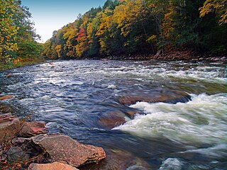
Swallow Falls State Park is a public recreation area located on the west bank of the Youghiogheny River nine miles (14 km) northwest of Oakland in Garrett County, Maryland, in the United States. The state park features Maryland's highest free-falling waterfall, the 53-foot (16 m) Muddy Creek Falls, as well as smaller waterfalls on the Youghiogheny River and Tolivar Creek. The park is notable for its stand of old hemlock trees, some more than 300 years old, "the last stand of its kind in Maryland."

Upper Pine Bottom State Park is a 5-acre (2.0 ha) Pennsylvania state park in Lycoming County, Pennsylvania in the United States. The park is in Cummings Township on Pennsylvania Route 44 and is surrounded by the Tiadaghton State Forest. It is on Upper Pine Bottom Run, which gave the park its name and is a tributary of Pine Creek. Upper Pine Bottom State Park is in the Pine Creek Gorge, where the streams have cut through five major rock formations from the Devonian and Carboniferous periods.
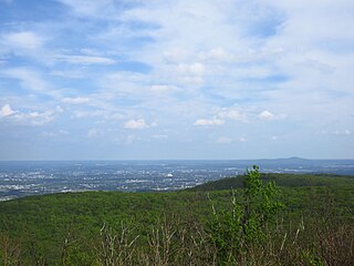
Gambrill State Park is a public recreation area located on Catoctin Mountain near the city of Frederick in Frederick County, Maryland. The state park is known for the dramatic views of the surrounding area that can be seen from stone overlooks built in the 1930s by the Civilian Conservation Corps. The park is operated by the Maryland Department of Natural Resources.

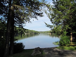
Black Moshannon State Park is a 3,480-acre (1,410 ha) Pennsylvania state park in Rush Township, Centre County, Pennsylvania, United States. It surrounds Black Moshannon Lake, formed by a dam on Black Moshannon Creek, which has given its name to the lake and park. The park is just west of the Allegheny Front, 9 miles (14 km) east of Philipsburg on Pennsylvania Route 504, and is largely surrounded by Moshannon State Forest. A bog in the park provides a habitat for diverse wildlife not common in other areas of the state, such as carnivorous plants, orchids, and species normally found farther north. As home to the "largest reconstituted bog in Pennsylvania", it was chosen by the Pennsylvania Department of Conservation and Natural Resources for its "25 Must-see Pennsylvania State Parks" list.

Hyner Run State Park is a 180-acre (73 ha) Pennsylvania state park in Chapman Township, Clinton County, Pennsylvania in the United States. The park is 6 miles (9.7 km) east of Renovo and 3 miles (5 km) north of Hyner on Pennsylvania Route 120. Hyner Run State Park is surrounded by Sproul State Forest.

R. B. Winter State Park is a Pennsylvania state park on 695 acres (281 ha) in Hartley Township, Union County, Pennsylvania in the United States. It is in the ridge and valley region of Pennsylvania and is surrounded by Bald Eagle State Forest. R. B. Winter State Park is in a shallow basin that is surrounded by ridges. Halfway Lake is the central recreational focus of the park. The park is 18 miles (29 km) west of Lewisburg on Pennsylvania Route 192.
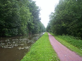
Delaware Canal State Park is a 830-acre (336 ha) Pennsylvania state park in Bucks and Northampton Counties in Pennsylvania. The main attraction of the park is the Delaware Canal which runs parallel to the Delaware River between Easton and Bristol.

Maryland Route 364 is a state highway in the U.S. state of Maryland. Known as Dividing Creek Road, the state highway runs 5.43 miles (8.74 km) from U.S. Route 13 in West Pocomoke north to Pocomoke State Forest. MD 364 parallels the Pocomoke River and provides access to Pocomoke River State Park. The state highway was mostly constructed in the early 1930s.
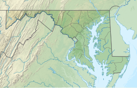
The Maryland Department of Natural Resources (DNR) is a government agency in the state of Maryland charged with maintaining natural resources including state parks, public lands, state forests, state waterways, wildlife, and recreation areas. Its headquarters are in Annapolis.
Robinson State Park is a state-owned, public recreation area located mostly in the town of Agawam with a small section in Westfield, Massachusetts. The narrow, 1,025-acre (415 ha) state park follows the course of the meandering Westfield River which forms the park's northern border. The park is managed by the Massachusetts Department of Conservation and Recreation.
Erving State Forest is a publicly owned forest with recreational features located north of the Millers River in the towns of Erving, Warwick, and Orange, Massachusetts. The property is centered on Laurel Lake, a 51-acre (21 ha) body of water that has been a popular recreational destination since the 1930s. The forest's network of roads and hiking trails were largely created by the Civilian Conservation Corps. The forest is managed by the Department of Conservation and Recreation.

New Germany State Park is a public recreation area covering 508 acres (206 ha) adjacent to the Savage River State Forest in Garrett County, Maryland. The state park is administered by the Maryland Department of Natural Resources.
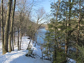
Pocomoke State Forest is a state forest of Maryland that lies on both banks of the Pocomoke River in Worcester County. The portion north of the Pocomoke lies between Dividing and Nassawango Creeks. The Pocomoke River Wildlife Management Area borders the southern portion of the forest.
The Pocomoke River Wildlife Management Area is a state-run nature reserve found on the southern banks of the Pocomoke River in Worcester County, Maryland.

Big Run State Park is a public recreation area located at the northern end of the Savage River Reservoir, an impoundment of the Savage River, in Garrett County, Maryland. The state park occupies 300 acres (120 ha) in Savage River State Forest and encompasses the confluence of Monroe Run and Big Run. Park activities include boating, fishing, hiking, picknicking, and camping.
Mohican-Memorial State Forest is a state forest in Ashland County, Ohio, United States. Mohican-Memorial State Forest is used for forest research, demonstrations of good forest management, tree seed for nurseries, recreation, and protection of soil and watershed.

Otter River State Forest is a publicly owned forest and recreational preserve located in the towns of Templeton, Winchendon, and Royalston in Massachusetts managed by the Massachusetts Department of Conservation and Recreation. The state forest encompasses the land surrounding the junction of the Otter and Millers rivers. Habitats include freshwater marsh, northern hardwood stands, and pine groves planted by the Civilian Conservation Corps to reforest former farmlands.
The Beltrami Island State Forest is a state forest located in Lake of the Woods, Roseau, and Beltrami counties, Minnesota. Named after Italian explorer Giacomo Beltrami, it is the second-largest state forest in the Minnesota system after Pine Island State Forest. The largest wildlife management area in the state at 321,149 acres (129,964 ha), the Red Lake Wildlife Management Area, is located within the forest. The majority of the forest is managed by the Minnesota Department of Natural Resources, although a significant portion are tribal lands belonging to the neighboring Red Lake Band of Ojibwe.