
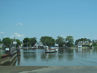
Vienna is a town in Dorchester County, Maryland, United States. The population was 271 at the 2010 census.
The Wicomico River is a 24.4-mile-long (39.3 km) tributary of the Chesapeake Bay on the eastern shore of Maryland. It drains an area of low marshlands and farming country in the middle Delmarva Peninsula.
The Nanticoke River is a tributary of the Chesapeake Bay on the Delmarva Peninsula. It rises in southern Kent County, Delaware, flows through Sussex County, Delaware, and forms the boundary between Dorchester County, Maryland and Wicomico County, Maryland. The tidal river course proceeds southwest into the Tangier Sound, Chesapeake Bay. The river is 64.3 miles (103.5 km) long. A 26-mile ecotourism water trail running along the River was set aside in July 2011 by Delaware state and federal officials, contiguous with a 37-mile water-trail extending through Maryland to the Chesapeake Bay.
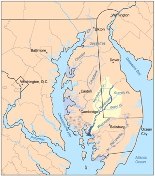
Marshyhope Creek is a 37.0-mile-long (59.5 km) tributary of the Nanticoke River on the Delmarva Peninsula. It rises in Kent County, Delaware, and runs through Caroline County, Maryland, and Dorchester County, Maryland.
Pocomoke State Forest is a state forest of Maryland that lies on both banks of the Pocomoke River in Worcester County. The portion north of the Pocomoke lies between Dividing and Nassawango Creeks. The Pocomoke River Wildlife Management Area borders the southern portion of the forest.
The Pocomoke River Wildlife Management Area is a state-run nature reserve found on the southern banks of the Pocomoke River in Worcester County, Maryland.
E.A. Vaughn Wildlife Management Area is a state wildlife management area (WMA) of Maryland that consists of two separate parcels of land on Chincoteague Bay in Worcester County, between the villages of Girdletree and Stockton.
Isle of Wight Wildlife Management Area is a state wildlife management area (WMA) of Maryland located on the Isle of Wight, a small peninsula between the St. Martin's River and Isle of Wight Bay in Worcester County. Although called Isle of Wight, a small strip of marsh and road connects it with the mainland.
Johnson Wildlife Management Area is a Wildlife Management Area in Wicomico County, Maryland.
Linkwood Wildlife Management Area is a 313-acre (1.27 km2) Wildlife Management Area located in Dorchester County, Maryland, near the town of Linkwood.
Maryland Marine Properties Wildlife Management Area is a Wildlife Management Area in Somerset County, Maryland.
Myrtle Grove Wildlife Management Area is a Wildlife Management Area in Charles County, Maryland, United States.
Pocomoke Sound Wildlife Management Area is a Wildlife Management Area in Somerset County, Maryland.
Wellington Wildlife Management Area is a Wildlife Management Area in Somerset County, Maryland.
Le Compte Wildlife Management Area is a Wildlife Management Area in Dorchester County, Maryland.
Isle of Wight is an island in Worcester County, Maryland. The island is in Isle of Wight Bay at the mouth of St. Martin River just west of Ocean City on Fenwick Island in eastern Maryland. The Ocean City Expressway crosses the island between the mainland and Fenwick Island.

Elk Neck Peninsula is in Cecil County, Maryland, between the towns of Elkton and North East, Maryland. Native American and colonial travelers often canoed or sailed up the Chesapeake Bay to Elkton, where the Elk River became unnavigable, and then walked or took some form of surface transportation to the Delaware Bay watershed, since this was the shortest surface crossing. Native Americans of the area, including the Nanticoke and Lenni Lenape, hunted and fished, as well as established semi-permanent camps.
Manokin River is a river in Somerset County, Maryland, that flows into Tangier Sound, an arm of the Chesapeake Bay. The Manokin rises east of Princess Anne, Maryland, flows through the town, then widens into a tidal estuary. Tributaries along the river's 17-mile (27 km) length are Kings Creek, Back Creek, St. Peters Creek, Broad Creek, and Fishing Creek. During the colonial period, the Manokin was navigable as far as Princess Anne.
Old Bohemia Wildlife Management Area is a Wildlife Management Area in Cecil County, Maryland.
Nanticoke Wildlife Area is a state wildlife area located in Sussex County, Delaware, along the Nanticoke River and Broad Creek, near to Seaford, Delaware, and Bethel, Delaware. There is a monument commemorating Captain John Smith's journey into the Chesapeake Bay and its tributaries at Phillips Landing along Broad Creek, a tributary of the Nanticoke River in Delaware. It is made up of three large land tracts totaling 4,510 acres (1,825 ha), it is managed by Delaware Department of Natural Resources and Environmental Control (DNREC), Division of Fish and Wildlife. The area also holds one of the few Delmarva fox squirrel populations within Delaware, along with controlled populations in Prime Hook Wildlife Refuge and Assawoman Wildlife Area.