Fort Smallwood Park

Last updated
Fort Smallwood Park
Battery Hartshorne Dec 09.JPG
Battery Hartshorne, Fort Smallwood Park, December 2009
Location Anne Arundel County, Maryland, U.S.
Nearest city Pasadena, Maryland
Coordinates 39°9′51.75″N76°28′36.72″W / 39.1643750°N 76.4768667°W / 39.1643750; -76.4768667
Established1928
Governing body Anne Arundel County, Maryland

Fort Smallwood Park is a county park in northeastern Anne Arundel County, near Riviera Beach and Pasadena, Maryland, United States. It is located on the outer Patapsco River as it meets the Chesapeake Bay, on a peninsula known as Rock Point.

Contents

On April 1, 2006 it became a regional park in the Anne Arundel County Park System, after being transferred from the Department of Recreation and Parks of Baltimore City after extensive decades-long negotiations. On September 19, 2009 County Executive John R. Leopold officially dedicated the 380-foot (120 m) fishing pier at Fort Smallwood Park "Bill Burton Fishing Pier", named for the long-time Baltimore Sun outdoorsman/reporter and columnist. The previous pier was destroyed in 2003 by Hurricane Isabel. It provides a view of the Sparrows Point plant of Mittal Steel Company (formerly owned by Bethlehem Steel Corporation), one of the largest steel manufacturing complexes in the world. [1]

Fort Smallwood Road (Maryland Route 173) leads from Patapsco Avenue and Pennington Avenue in Brooklyn-Curtis Bay in southern Baltimore City across Curtis Creek, past the U.S. Coast Guard Yard through the Arundel Cove-Hawkins Point area to Riviera Beach and Pasadena coastal communities across Stony Creek to the old fort and park.

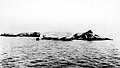
A cluster of rock outcroppings known as White Rocks is located in the water northwest of the park. [2]

History

From 1896 to 1928, it was an Endicott Period Coastal Fort built during the Spanish–American War era along with other outer harbor defenses at Fort Howard on North Point in southeastern Baltimore County and Fort Armistead at Hawkins Point on the Baltimore City-Anne Arundel County Line of 1919. It was named for Revolutionary War Maj. Gen. William Smallwood (1732–1792), commander of the "Maryland Line" regiment in the Continental Army who later became fourth governor of Maryland (1785–1788).[ citation needed ]

From 1928 to 2006, it was a city park of the City of Baltimore and was an extremely popular weekend picnicking, swimming and fishing site for city and county citizens in the 1930s to the 80s, until later eclipsed by other Chesapeake Bay resorts and eventually Ocean City and the Delaware beaches after the construction of the Chesapeake Bay Bridge in 1952. Besides Robert E. Lee Memorial Park surrounding Lake Roland, a former Baltimore City Public Works Department watershed system parcel since 1860, located just across the northern city limits in Baltimore County, Fort Smallwood was the only city park located outside the 1919 city limits. [3]

It is the location of Battery Hartshorne, named on November 18, 1902 in honor of Captain Benjamin M. Hartshorne Jr., 7th U. S. Infantry, who was killed on January 2, 1902, in action with insurgents near Lanang, Samar, Philippine Islands during the Philippine–American War. Two six-inch disappearing carriage guns were mounted here from 1900 to 1927. [4]

Recreation

See also

Related Research Articles

<span class="mw-page-title-main">Anne Arundel County, Maryland</span> County in Maryland, United States

Anne Arundel County, also notated as AA or A.A. County, is located in the U.S. state of Maryland. As of the 2020 United States census, its population was 588,261, an increase of just under 10% since 2010. Its county seat is Annapolis, which is also the capital of the state. The county is named for Anne Arundell, Lady Baltimore, a member of the ancient family of Arundells in Cornwall, England, and the wife of Cecilius Calvert, 2nd Baron Baltimore (1605–1675), founder and first lord proprietor of the colony Province of Maryland.

<span class="mw-page-title-main">Pasadena, Maryland</span> Census-designated place in Maryland, United States

Pasadena is a census-designated place (CDP) in Anne Arundel County, Maryland, United States. The population was 24,287 at the 2010 census.

<span class="mw-page-title-main">Patapsco River</span> River in Maryland, United States

The Patapsco River mainstem is a 39-mile (63 km) river in central Maryland that flows into the Chesapeake Bay. The river's tidal portion forms the harbor for the city of Baltimore. With its South Branch, the Patapsco forms the northern border of Howard County, Maryland. The name "Patapsco" is derived from the Algonquian pota-psk-ut, which translates to "backwater" or "tide covered with froth".

<span class="mw-page-title-main">Seven Foot Knoll Light</span> Lighthouse in Maryland, United States

The Seven Foot Knoll Light was built in 1855 and is the oldest screw-pile lighthouse in Maryland. It was located atop Seven Foot Knoll in the Chesapeake Bay until it was replaced by a modern navigational aid and relocated to Baltimore's Inner Harbor as a museum exhibit.

<span class="mw-page-title-main">Francis Scott Key Bridge (Baltimore)</span> Bridge in Maryland, U.S. (1977–2024)

The Francis Scott Key Bridge was a steel arch continuous through truss bridge that spanned the lower Patapsco River and outer Baltimore Harbor/Port in Maryland, United States. Opened on March 23, 1977, it carried the Baltimore Beltway between Dundalk in Baltimore County and Hawkins Point, an isolated southern neighborhood of Baltimore, while briefly passing through Anne Arundel County. The main spans and part of the northeastern approach of the bridge collapsed on March 26, 2024, after the container ship MV Dali struck one of its piers.

<span class="mw-page-title-main">Curtis Bay, Baltimore</span> Neighborhood of Baltimore in Maryland, United States

Curtis Bay is a residential / commercial / industrial neighborhood in the southern portion of the City of Baltimore, Maryland, United States.

<span class="mw-page-title-main">Anne Arundel County Public Schools</span> School District serving Anne Arundel County Maryland

Anne Arundel County Public Schools is the public school district serving Anne Arundel County, Maryland. With over 80,000 students, the AACPS school system is the 4th largest in Maryland and the 39th largest in the United States. The district has over 5,000 teachers supporting a comprehensive curriculum from Pre-K through 12th grade.

<span class="mw-page-title-main">Maryland Route 173</span> State highway in Maryland

Maryland Route 173 is a state highway in the U.S. state of Maryland. Known for most of its length as Fort Smallwood Road, the state highway runs 13.78 miles (22.18 km) from Fort Smallwood Park near Jacobsville north to MD 2 in the Brooklyn neighborhood of Baltimore. MD 173 connects the beach communities of Riviera Beach and Orchard Beach in northeastern Anne Arundel County and Interstate 695 (I-695) with industrial areas in the Baltimore neighborhoods of Hawkins Point and Curtis Bay, including the United States Coast Guard Yard. MD 173 was mostly constructed in the 1920s and early 1930s. The state highway was put in its modern form with the completion of the bridge over Stony Creek in the late 1940s and expansion to a divided highway between Orchard Beach and Curtis Bay in the late 1970s.

<span class="mw-page-title-main">Port of Baltimore</span> Cargo port in Baltimore, Maryland, US

The Helen Delich Bentley Port of Baltimore is a shipping port along the tidal basins of the three branches of the Patapsco River in Baltimore, Maryland, on the upper northwest shore of the Chesapeake Bay. It is the nation's largest port facility for specialized cargo and passenger facilities. It is operated by the Maryland Port Administration (MPA), a unit of the Maryland Department of Transportation.

Arundel-on-the-Bay is a former post village and resort area in Anne Arundel County, Maryland, United States, located approximately 2 miles (3.2 km) southeast of Annapolis. Arundel-on-the-Bay is located on a peninsula known as the Annapolis Neck and is a peninsula in and of itself, bordered on the east and south by the Chesapeake Bay, and by Fishing Creek on the west.

<span class="mw-page-title-main">Chesapeake High School (Pasadena, Maryland)</span> Public high school in Pasadena, Maryland, United States

Chesapeake High School (CHS) is a public high school in Pasadena, Maryland. It is one of two public high schools in Pasadena, the other being Northeast High School.

<span class="mw-page-title-main">Brooklyn, Baltimore</span> Neighborhood of Baltimore in Maryland, United States

Brooklyn is one of the southernmost neighborhoods in Baltimore, Maryland. It is located near Anne Arundel County along Governor Ritchie Highway which is also Maryland Route 2. Its main roads are South Hanover Street,, Potee Street, and East Patapsco Avenue, Sixth Street, Tenth Street, and West Bay Avenue which borders the neighboring Curtis Bay community to the east, running through Bay Brook Park, which separates the two. South Hanover Street also serves as the dividing line between east–west streets in Brooklyn, as Charles Street does not exist here.

<span class="mw-page-title-main">North Point State Park</span> State park in Maryland, United States

North Point State Park is a public recreation area located on Chesapeake Bay in Edgemere, Baltimore County, Maryland. The state park includes the site of the former Bay Shore Park, which was one of the state's premiere amusement parks during the first half of the 20th century. The park features restored remnants of the old amusement park as well as facilities for swimming, picnicking, bicycling, and hiking. Black Marsh, a 667-acre (270 ha) state wildlands area, makes up half the park's area. The park is administered by the Maryland Department of Natural Resources.

<span class="mw-page-title-main">Polish Home Hall</span> United States historic place

Polish Home Hall is a historic building located in the waterfront industrial/commercial/residential and heavily ethnic community of Curtis Bay in southern Baltimore, Maryland,. Built on the southwest corner of Fairhaven Avenue and Filbert Street near the top of the commanding heights overlooking to the east the sloping streets of the neighborhood of Curtis Bay, about four city blocks wide and 15 blocks length.

<span class="mw-page-title-main">Maryland Route 261</span> State highway in Maryland, United States

Maryland Route 261 is a state highway in the U.S. state of Maryland. The highway runs 12.86 miles (20.70 km) from MD 263 near Parran north to MD 778 at Friendship. MD 261 connects Prince Frederick with and serves as the main street through the Chesapeake Bay beach communities of Chesapeake Beach and North Beach in northeastern Calvert County and Rose Haven in southeastern Anne Arundel County. The highway was constructed from north of its present terminus through Chesapeake Beach in the early 1930s. The road was built as MD 613 east from Friendship in the mid-1930s and extended east to Rose Haven in the late 1940s. MD 261 was extended south to its present terminus near Parran and north through North Beach to Rose Haven in the mid-1950s. MD 261 took over MD 613 west to Friendship in the early 1960s.

Chestnut Hill Cove is an unincorporated community in Anne Arundel County, Maryland, United States.

<span class="mw-page-title-main">Hawkins Point, Baltimore</span> Neighborhood in Baltimore, Maryland, United States

Hawkins Point is a neighborhood in the South District of Baltimore, located at the southern tip of the city between Curtis Bay (north) and the Anne Arundel County line (south) and Thoms Cove (east). Its land area covers 2.6 square miles (6.7 km2), and it had a population of 24 people according to the 2020 U.S. Census. The neighborhood is predominantly industrial.

<i>Emma Giles</i>

The Emma Giles was the best known and most popular sidewheel passenger steamer that operated out of Baltimore, Maryland.

Quiet Waters Park is a park in eastern Anne Arundel County, Maryland, United States. It contains 340 acres (1.4 km2) and is operated by the Anne Arundel Recreation and Parks. It is open year-round. Organizations using the park include the Friends of Quiet Waters Park. As of 2010, it attracts 700,000 visitors a year.

Anne Arundel County Public Library (AACPL) is a public library system located in central Maryland. Established in 1921 as the Annapolis and Anne Arundel County Public Library, Inc, the system now includes 16 locations throughout Anne Arundel County, Maryland.

References

  1. "Fort Smallwood Park website". Archived from the original on 2014-03-04. Retrieved 2010-01-01.
  2. Sparrows Point, MD 7.5' quadrangle, USGS (2019)
  3. Fort Smallwood – Fort Wiki
  4. Battery Hartshorne, wikimapia.com