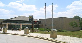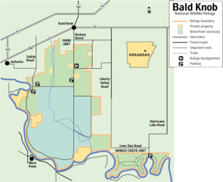
The Bald Knob National Wildlife Refuge is a 15,022 acres (60.79 km2) (2014) wildlife refuge located in White County, Arkansas about two miles south of the town of Bald Knob. The refuge is managed by the United States Fish and Wildlife Service. The refuge features large numbers of migratory waterfowl and bald eagles during the winter months.
Montezuma National Wildlife Refuge is a wildlife preserve operated by the United States Fish and Wildlife Service, encompassing part of the Montezuma Swamp at the north end of Cayuga Lake. The 10,004-acre (40.48 km2) preserve is composed of swamps, pools and channels and is a stopping point for migratory birds. It is the largest contiguous wetland complex in the northeastern United States and comprises a portion of the larger Montezuma Wetlands Complex, which is a partnership between the USFWS, the New York State Department of Environmental Conservation, as well as several other non-profit support organizations.

Missisquoi National Wildlife Refuge is a National Wildlife Refuge in the U.S. state of Vermont located on the eastern shore of Lake Champlain and the southern side of Missisquoi Bay. The refuge is in Franklin County in the northwest corner of the state near the International Boundary with Canada.
The Wheeler National Wildlife Refuge is a 35,000-acre (142 km2) national wildlife refuge (NWR) located along the Tennessee River near Decatur, Alabama. Named after Major General Joseph Wheeler, it was established to provide a habitat for wintering and migrating birds in the Eastern United States.

The Arthur R. Marshall Loxahatchee National Wildlife Refuge is a 145,188-acre (587.55 km2) wildlife sanctuary is located west of Boynton Beach, in Palm Beach County, Florida. It is also known as Water Conservation Area 1 (WCA-1). It includes the most northern remnant of the historic Everglades wetland ecosystem.

The Great Meadows National Wildlife Refuge is a 12-mile-long (19 km) river wetlands conservation area, in two major parcels, stretching from the towns of Billerica, Massachusetts (downstream) to Wayland, Massachusetts (upstream), along the Concord River and Sudbury River.

The Patuxent Wildlife Research Center is a biological research center in Laurel, Maryland, part of the Eastern Ecological Science Center (EESC) of the U.S. Geological Survey (USGS). The EESC is the largest of the 15 USGS research centers. The Patuxent facility is located on the grounds of the 12,841-acre (51.97 km2) Patuxent Research Refuge, managed by the U.S. Fish and Wildlife Service (FWS). This is the only National Wildlife Refuge in the United States initially established to support wildlife research.

The Erie National Wildlife Refuge is an 8,777-acre (3,552 ha) National Wildlife Refuge located in Crawford County, Pennsylvania. Named after the Erie tribe, it was established to provide waterfowl and other migratory birds with nesting, feeding, brooding, and resting habitat.
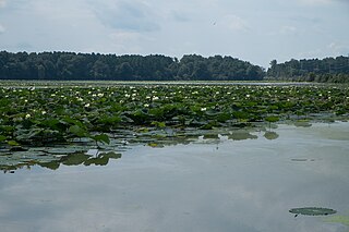
Crab Orchard National Wildlife Refuge is a 43,890 acre (180 km2) National Wildlife Refuge primarily in southwestern Williamson County, but with small extensions into adjacent eastern Jackson and northeastern Union counties of southern Illinois, in the United States. Its land and water contain a wide diversity of flora and fauna. It centers on Crab Orchard Lake. Major habitat types on the refuge include hardwood forest, agricultural land, grazing units, brushland, wetlands, and lakes. Other major bodies of water on the refuge are Devil's Kitchen Lake and Little Grassy Lake.
The Yazoo National Wildlife Refuge is a 12,941 acre (52.4 km2) National Wildlife Refuge located in Washington County, Mississippi. Named after the Yazoo tribe, it was established to provide waterfowl and other migratory birds in the Mississippi Flyway with nesting, feeding, brooding, and resting habitat.

The Mingo National Wildlife Refuge is a 21,676-acre (87.7-km2) National Wildlife Refuge located in northwestern Stoddard and southeastern Wayne counties in Missouri. Its southwesternmost portion lies on the shores of Lake Wappapello. Named after the Mingo tribe, it was established to preserve bottomland hardwoods and provide waterfowl and other migratory birds in the Mississippi Flyway with nesting, feeding, brooding, and resting habitat.

The Atlantic Flyway is a major north-south flyway for migratory birds in North America. The route generally starts in Greenland, then follows the Atlantic coast of Canada, then south down the Atlantic Coast of the United States to the tropical areas of South America and the Caribbean. Every year, migratory birds travel up and down this route following food sources, heading to breeding grounds, or traveling to overwintering sites.
The Rydell National Wildlife Refuge is an 2,120-acre (9 km2) National Wildlife Refuge in northwestern Minnesota, located in Woodside Township, Polk County, just west of Erskine in northwestern Minnesota. It was established in 1992, and receives more than 7,800 visitors each year. The refuge is a combination of maple/basswood/oak forest, wetlands, tallgrass prairie and bogs.
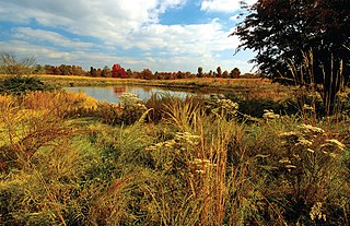
The Occoquan Bay National Wildlife Refuge is a National Wildlife Refuge located where the Occoquan River meets the Potomac River in Woodbridge, Virginia, United States between Belmont Bay and Occoquan Bay. The 644-acre (2.61 km2) site, about half of which is wetlands, was a popular tourist spot known as Dawson Beach until the 1940s, after which it was used for military research by the U.S. Army's Harry Diamond Laboratories from the 1960s to the 1990s. When the land was purchased from the military, it was temporarily called the Marumsco National Wildlife Refuge. The refuge was formally established and renamed in 1998, and is now managed by the United States Fish and Wildlife Service as part of the Potomac River National Wildlife Refuge Complex.

Black Bayou Lake National Wildlife Refuge is one of five refuges managed in the North Louisiana Refuge Complex and one of 545 refuges in the National Wildlife Refuge System. It was established in 1997 through a unique partnership with the city of Monroe, Louisiana. The U.S. Fish and Wildlife Service has a free 99-year lease to manage the city-owned lake.

The Sonny Bono Salton Sea National Wildlife Refuge is located in the Imperial Valley of California, 40 miles (64 km) north of the Mexican border. Situated at the southern end of the Salton Sea, the refuge protects one of the most important nesting sites and stopovers along the Pacific Flyway. Despite its location in the Colorado Desert, a subdivision of the larger Sonoran Desert, the refuge contains marine, freshwater, wetland, and agricultural habitats which provide sanctuary for hundreds of birds and wetland species, including several that have been listed as endangered or sensitive by the U.S. Fish and Wildlife Service.
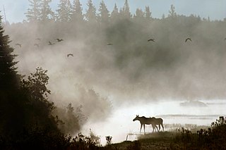
Aroostook National Wildlife Refuge is located on part of the former Loring Air Force Base, in Aroostook County, Maine. It was established in 1998, when 4,700 acres (19 km2) were transferred from the United States Air Force to the United States Fish and Wildlife Service. This refuge also administers some 2,400 acres (970 ha) of wetland conservation easements throughout Aroostook County. It is close to the Aroostook State Park where visitors can camp, hike, fish, and cross-country ski. In a portion of Maine where the landscape is dominated by agricultural crops such as potatoes and broccoli, Aroostook National Wildlife Refuge protects valuable wildlife habitat. The variety of habitat types attracts a diversity of wildlife species.
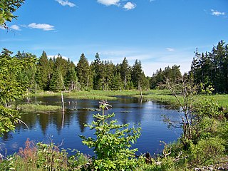
Moosehorn National Wildlife Refuge is one of the northernmost National Wildlife Refuges in the Atlantic Flyway, a migratory route that follows the eastern coast of North America. The refuge provides important feeding and nesting habitat for many bird species, including waterfowl, wading birds, shorebirds, upland game birds, songbirds, and birds of prey.

Eastern Neck National Wildlife Refuge, a part of the Chesapeake Marshlands National Wildlife Refuge Complex, is a 2,286-acre (9.25 km2) island located at the confluence of the Chester River and the Chesapeake Bay. Established in 1962 as a sanctuary for migratory birds, Eastern Neck National Wildlife Refuge provides natural habitat for over 240 bird species — including bald eagles and transitory peregrine falcons — and is a major staging site for tundra swans.
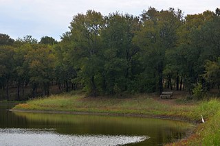
Hagerman National Wildlife Refuge (HNWR), a haven for migratory birds and other wildlife, lies in northwestern Grayson County, Texas, on the Big Mineral Arm of Lake Texoma, on the Red River between Oklahoma and Texas. This National Wildlife Refuge is made up of water, marsh, and upland habitat. Visitors can hike, observe wildlife, hunt, and fish throughout the year.
