
The Baltimore Convention Center is a convention and exhibition hall located in downtown Baltimore, Maryland. The center is a municipal building owned and operated by the City of Baltimore.
Hunt Valley is an unincorporated community in Baltimore County, Maryland, United States, near the site of the Maryland Hunt Cup Steeplechase. It lies just north of the city of Baltimore, along York Road, parallel to Interstate 83. The nearby Loch Raven Reservoir is an important landmark and drinking water resource. Its surrounding forested watershed is one of three reservoirs established for the City of Baltimore. Hunt Valley is located at a latitude of 39.5° North and longitude of 76.7° West. It is served by the Cockeysville post office, and is also a neighbor of Timonium. A satellite campus of the Community College of Baltimore County is located in Hunt Valley Town Centre.

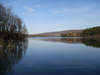
Deep Creek Lake State Park is a public recreation area occupying more than 1,100 acres (450 ha) on the northeast side of Deep Creek Lake in Garrett County, Maryland, in the United States. The park features water activities, camping facilities, and recreational trails and is located about 18 miles (29 km) south of Interstate 68 on U.S. Route 219.

Maryland Route 200, also known as the Intercounty Connector or ICC, is an 18.8-mile (30.3 km) controlled-access toll road in the U.S. state of Maryland. It connects Gaithersburg in Montgomery County and Laurel in Prince George's County, both of which are suburbs of Washington, D.C. The ICC was one of the most controversial Maryland road projects; opposition to the highway stalled the project for decades, and construction did not begin until 60 years after the highway's initial approval.
Rocky Gap State Park is a public recreation area with resort features located on Interstate 68, seven miles (11 km) east of Cumberland in Allegany County, Maryland. The state park's 3,000 acres (1,200 ha) include Lake Habeeb, Evitts Mountain, and the privately owned and operated Rocky Gap Casino Resort. The park offers water recreation, camping facilities, and hiking trails. The park is managed by the Maryland Department of Natural Resources, the resort by Century Casinos.

Russett is an unincorporated planned community of 613 acres (2.48 km2) within the Maryland City census-designated place in far-western Anne Arundel County, Maryland, United States, near the city of Laurel. It is situated in a park-like setting complemented by 12 miles (19 km) of walking trails and a 70-acre (280,000 m2) lake nature preserve.

Owings Mills Mall was a shopping mall in Owings Mills, Maryland, United States that hosted 155 stores and eateries, in the Baltimore County, Maryland, community of Owings Mills. It was owned and managed by General Growth Properties. While its main entrance was off Red Run Boulevard between Painters Mill Road and Owings Mills Boulevard, the mall was also accessible from the exit ramps of I-795. It was originally known as Owings Mills Town Center. The mall was completely demolished in 2017, and redeveloped in 2019 as Mill Station.

Patapsco Valley State Park is a Maryland state park extending along 32 miles (51 km) of the Patapsco River south and west of the city of Baltimore, Maryland. The park encompasses multiple developed areas on over 14,000 acres (5,700 ha) acres of land, making it Maryland's largest state park. In 2006, it was officially celebrated as Maryland's first state park, its first formation being in 1906. Patapsco Valley State Park is managed by the Maryland Department of Natural Resources.
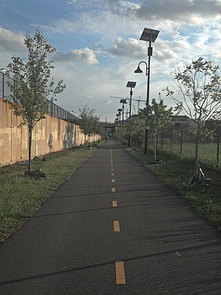
The Metropolitan Branch Trail is an American rail trail between the transit center in Silver Spring, Maryland, and Union Station in the District of Columbia. It runs for 8 miles (13 km): one in Maryland and seven within Washington, D.C. The trail parallels Metrorail and CSX tracks along a right-of-way opened in 1873 as the Baltimore and Ohio Railroad (B&O)'s Metropolitan Branch.

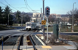
Lake Roland is a city/county park encompassing over 500 acres of woodland, wetlands, serpentine barrens, rare plants and rocky plateaus surrounding Lake Roland in Baltimore County, Maryland. The park is located near the intersection of Falls Road and Lake Avenue, adjacent to the Falls Road Light Rail Stop of the Baltimore Light Rail, which runs from Cromwell Station near Glen Burnie in Anne Arundel County in the south to Hunt Valley of Baltimore County. The line runs along a railroad embankment and trestle over the lake above the dam, cutting the park into a two-thirds wooded northern part and the one-third southern portion around the dam, picnic groves, pavilion and pumping station.

Greenbrier State Park is a public recreation area located on South Mountain, three miles (4.8 km) northeast of Boonsboro in Washington County, Maryland, USA. The state park has camping, hiking trails, and a 42-acre (17 ha) man-made lake. It is managed by the Maryland Department of Natural Resources.

Baltimore is the most populous city in the U.S. state of Maryland. With a population of 585,708 at the 2020 census, it is the 30th-most populous city in the United States. Baltimore was designated an independent city by the Constitution of Maryland in 1851, and is currently the most populous independent city in the nation. As of the 2020 census, the population of the Baltimore metropolitan area was 2,838,327, the 20th-largest metropolitan area in the country. When combined with the larger Washington metropolitan area, the Washington–Baltimore combined statistical area (CSA) has a 2020 U.S. census population of 9,973,383, the third-largest in the country. Though the city is not located within or under the administrative jurisdiction of any county in the state, it is considered to be part of the Central Maryland region, together with the surrounding county that shares its name.
Gwynns Falls/Leakin Park is a park in Baltimore, Maryland. It is the second-largest woodland park in the United States, constituting a contiguous area of 1,216 acres (492 ha). Envisioned as a "stream valley park" to protect Baltimore's watersheds, including the Gwynns Falls, from overdevelopment and to preserve their natural habitats. It is well known for the fact that over 75 bodies have been discovered in the park since the 1940s. It is also home to the Baltimore Herb Festival.
The Middle Patuxent Environmental Area (MPEA) is a 1,021-acre (4.13 km2) wildlife area in Clarksville, Maryland and operated by the Howard County Department of Recreation and Parks. It is located next to the River Hill village in the town of Columbia, Maryland, in the United States. The MPEA was created in 1996 for educational, research, and recreational purposes.
Piney Run Park is a nature park in Sykesville, located in Carroll County, Maryland. It is Carroll County's oldest developed park and hosts thousands of visitors annually. The park encompasses 550 acres of fields, forest and open spaces, features over 15 miles of hiking trails, a 300-acre lake and many sports and recreational facilities. Prior to being a park, this land was a private farm.

The James and Anne Robinson Nature Center is a nature education facility situated on 18 acres of park land adjacent to the Middle Patuxent Environmental Area. Geothermal heating/air-conditioning, porous paving, solar panels, water conservation methods and other features make this building environmentally-friendly and have earned it the LEED Certified Platinum designation. Each year, the Center runs over 450 programs including field trips, public programs, birthday parties, home school and scout programs. James and Anne Robinson cared for the property for decades and kept it from being used by developers, ultimately arranging transfer to Howard County, Maryland for enjoyment by the general public. The Center continues to be partially supported by the James & Anne Robinson Foundation and is owned and operated by the Howard County Department of Recreation & Parks.
The Alpha Ridge Landfill is a municipal solid waste landfill located in Marriottsville, Maryland, once known as the postal town of Alpha, Maryland.

The South Shore Trail is a 11.2-mile (18.0 km) long, planned shared-use rail trail that will run from Annapolis to Odenton in Maryland, United States. Two segments, totaling 2.96-mile (4.76 km) have been built. The Trail primarily utilizes the abandoned road bed of the Annapolis and Elk Ridge Railroad. The trail will connect with the Colonial Annapolis Maritime Trail on the east and the Washington, Baltimore and Annapolis Trail, via the Odenton Bike Path, on the west. When complete, it will be a component of the American Discovery Trail, the East Coast Greenway and the September 11th National Memorial Trail. The trail name is a reference to the railroad it replaces which during its last 10 years in operation was known as the South Shore Division because it ran along the south shore of the Severn River.
Masonville was a residential community and suburban neighborhood of Baltimore, Maryland. Historically, the town was one of five neighboring communities sought and ultimately annexed by Baltimore City from Anne Arundel County in 1918. The town was razed in its entirety in the 1950s, to accommodate the expansion of the Baltimore & Ohio Railroad's Curtis Bay terminal.


