Francis Nash was a brigadier general in the Continental Army during the American Revolutionary War. Prior to the war, he was a lawyer, public official, and politician in Hillsborough, North Carolina, and was heavily involved in opposing the Regulator movement, an uprising of settlers in the North Carolina piedmont between 1765 and 1771. Nash was also involved in North Carolina politics, representing Hillsborough on several occasions in the colonial North Carolina General Assembly.

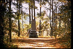
Kings Mountain National Military Park is a National Military Park near Blacksburg, South Carolina, along the North Carolina/South Carolina border. The park commemorates the Battle of Kings Mountain, a pivotal and significant victory by American Patriots over American Loyalists during the Southern Campaign of the Revolutionary War. It was listed on the National Register of Historic Places in 1996. Thomas Jefferson considered the battle "The turn of the tide of success."

The Battle of Great Bridge was fought December 9, 1775, in the area of Great Bridge, Virginia, early in the American Revolutionary War. The refusal by colonial Virginia militia forces led to the departure of Royal Governor Lord Dunmore and any remaining vestiges of British power over the Colony of Virginia during the early days of the conflict.
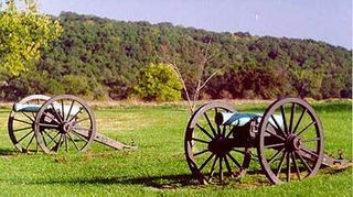
Wilson's Creek National Battlefield, located near Republic, Missouri, preserves the site of the Battle of Wilson's Creek. Fought on August 10, 1861, the battle was the first major American Civil War engagement west of the Mississippi River. In the battle, a Confederate army commanded by Benjamin McCulloch and Sterling Price defeated a smaller Union army commanded by Nathaniel Lyon. However, the Confederates were unable to hold much of Missouri, and a Confederate defeat at the Battle of Pea Ridge effectively solidified Union control of the state. Major features include a five-mile automobile tour loop, the restored 1852 Ray House, and "Bloody Hill", the site of the final stage of the battle. The site is located near Republic in southwestern Missouri just southwest of the city of Springfield. It has been a unit of the National Park Service since 1960, and was listed on the National Register of Historic Places in 1966.

The Battle of Kettle Creek was the first major victory for Patriots in the back country of Georgia during the American Revolutionary War that took place on February 14, 1779. It was fought in Wilkes County about eleven miles (18 km) from present-day Washington, Georgia. A militia force of Patriots decisively defeated and scattered a Loyalist militia force that was on its way to British-controlled Augusta.

The Battle of Moore's Creek Bridge was a minor conflict of the American Revolutionary War fought near Wilmington, North Carolina, on February 27, 1776. The victory of the North Carolina Provincial Congress' militia force over British governor Josiah Martin's and Tristan Worsley's reinforcements at Moore's was a turning point in the war; American independence was declared less than five months later.

The Overmountain Victory National Historic Trail (OVHT) is part of the U.S. National Trails System, and N.C. State Trail System. It recognizes the Revolutionary War Overmountain Men, Patriots from what is now East Tennessee who crossed the Unaka Mountains and then fought in the Battle of Kings Mountain in South Carolina.

The Overmountain Men were American frontiersmen from west of the Blue Ridge Mountains which are the leading edge of the Appalachian Mountains, who took part in the American Revolutionary War. While they were present at multiple engagements in the war's southern campaign, they are best known for their role in the American victory at the Battle of Kings Mountain in 1780. The term "overmountain" arose because their settlements were west of, or "over", the Blue Ridge, which was the primary geographical boundary dividing several of the 13 American states from the Native American lands to the west. The Overmountain Men hailed from parts of Virginia, North Carolina, and what is now Tennessee and Kentucky.

The 84th Regiment of Foot (Royal Highland Emigrants) was a British regiment in the American Revolutionary War that was raised to defend present-day Ontario, Quebec, and Atlantic Canada from the constant land and sea attacks by American Revolutionaries. The 84th Regiment was also involved in offensive action in the Thirteen Colonies; including North Carolina, South Carolina, Georgia, Virginia, and what is now Maine, as well as raids upon Lake Champlain and the Mohawk Valley. The regiment consisted of 2,000 men in twenty companies. The 84th Regiment was raised from Scottish soldiers who had served in the Seven Years' War and stayed in North America. As a result, the 84th Regiment had one of the oldest and most experienced officer corps of any regiment in North America. The Scottish Highland regiments were a key element of the British Army in the American Revolution.
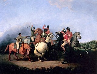
The southern theater of the American Revolutionary War was the central theater of military operations in the second half of the American Revolutionary War, 1778–1781. It encompassed engagements primarily in Virginia, Georgia, North Carolina, and South Carolina. Tactics consisted of both strategic battles and guerrilla warfare.
Ninety Six National Historic Site, also known as Old Ninety Six and Star Fort, is a United States National Historic Site located about 60 miles south of Greenville, South Carolina. The historic site was listed on the National Register in 1969, declared to be a National Historic Landmark in 1973, and established as a National Historic Site in 1976 to preserve the original site of Ninety Six, South Carolina, a small town established in the early 18th century. It encompasses 1,022 acres of property.
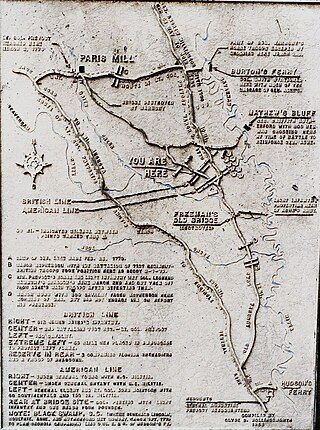
The Battle of Brier Creek was an American Revolutionary War battle fought on March 3, 1779, near the confluence of Brier Creek with the Savannah River in eastern Georgia. An American Patriot force consisting principally of militia from North Carolina and Georgia along with some Continental Army troops were defeated by British forces, suffering significant casualties. The rout damaged Patriot morale.

Griffith Rutherford was an American military officer in the Revolutionary War and the Cherokee-American Wars, a political leader in North Carolina, and an important figure in the early history of the Southwest Territory and the state of Tennessee.
Barbecue is an unincorporated community located in the Barbecue Township of Harnett County, North Carolina, United States. It is a part of the Dunn Micropolitan Area, which is also a part of the greater Raleigh–Durham–Cary Combined Statistical Area (CSA) as defined by the United States Census Bureau.
James Moore was an American military officer who served in the Continental Army during the American Revolutionary War. Moore was born into a prominent political family in the colonial Province of North Carolina, he was one of only five generals from North Carolina to serve in the Continental Army. He spent much of his childhood and youth on his family's estates in the lower Cape Fear River area, but soon became active in the colonial military structure in North Carolina.

The Battle of Beaufort, also known as the Battle of Port Royal Island, was fought on February 3, 1779, near Beaufort, South Carolina, during the American Revolutionary War. The battle took place not long after British forces consolidated control around Savannah, Georgia, which they had captured in December 1778.
The Battle of Lindley's Fort was part of a campaign by Loyalist and Cherokee forces to gain control over the South Carolina backcountry from Patriot forces early in the American Revolutionary War. The Cherokees were involved because ongoing encroachment of their territory in the area had led them to take up arms. These activities prompted settlers to seek refuge at Lindley's Fort in present-day Laurens County. A joint force of Cherokee and Loyalists adorned with Indian warpaint descended on the fort one day after about 150 militiamen arrived at the stockade fort. The defenders repulsed the attackers, and when they withdrew, made a sortie and pursued them. Two Loyalists were killed and 13 taken prisoner.
Francis Locke Sr. (1722–1796) was a plantation owner, businessman, politician, and a participant in the American War of Independence, where he led the American Patriots to the decisive victory at Ramseur's Mill, which turned the tide of the American War for Independence in the south.
NegroHead Road is a place outside Wilmington, North Carolina with similar displays in other Southern towns, where body parts of slaves or blacks were displayed in consequence of a purported crime. It is modeled after displays like Blackhead Signpost Road in Southampton County, Virginia. It was here, in 1831, where the head of a slave, Alfred, was displayed on a stake for being part of Nat Turner's Rebellion, as a warning for any future rebels.
In the first half of 1776, the Thirteen Colonies individually declared independence from the British Empire. On July 4, the Declaration of Independence marked the beginning of the United States.

