
The United States Fish and Wildlife Service is a U.S. federal government agency within the United States Department of the Interior which oversees the management of fish, wildlife, and natural habitats in the United States. The mission of the agency is "working with others to conserve, protect, and enhance fish, wildlife, plants and their habitats for the continuing benefit of the American people."

Hyde County is a county located in the U.S. state of North Carolina. As of the 2020 census, the population was 4,589, making it the second-least populous county in North Carolina. Its county seat is Swan Quarter. The county was created in 1705 as Wickham Precinct. It was renamed Hyde Precinct in 1712 and gained county status in 1739.

Swan Quarter is an unincorporated community and census-designated place (CDP) in Hyde County, North Carolina, United States. It is the county seat of Hyde County. As of the 2010 census, it had a population of 324.

The Tule Lake National Wildlife Refuge is a National Wildlife Refuge of the United States in northern California near the Oregon border. It covers 39,116 acres (15,830 ha) in the Tule Lake basin. It is part of the Klamath Basin National Wildlife Refuge Complex, and is a crucial part of the Pacific Flyway corridor for migratory birds.

Red Rock Lakes National Wildlife Refuge is a remote refuge located in the high elevation of the Centennial Valley, in the southwestern region of the U.S. state of Montana. Adjacent to Gallatin National Forest and near Yellowstone National Park, the refuge is an integral part of the Greater Yellowstone Ecosystem. Red Rock Lakes is best known for being the primary location for the efforts saving the trumpeter swan from extinction, which by 1932 had fewer than 200 known specimens in the United States and Canada. By the year 2002, an estimated 3,000 trumpeters were wintering on the refuge, many having migrated south from their summer range in Canada. The trumpeters are now so plentiful that efforts are being undertaken to help them reestablish historical migratory routes to areas further south in the Rocky Mountains and the Great Basin region. The elegant trumpeter swan is North America's largest waterfowl, with a wingspans of 8 feet and they can weigh up to 30 pounds (13 kg).
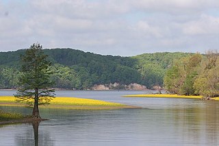
Lake Mattamuskeet is the largest natural lake in North Carolina. It is a shallow coastal lake, averaging 2–3 ft feet in depth, and stretches 18 miles (29 km) long and 7 miles (11 km) wide. Lake Mattamuskeet lies on the Albemarle-Pamlico Peninsula.

The Plum Island Range Lights are a pair of range lights located on Plum Island in Door County, Wisconsin. Plum Island was transferred to the United States Fish and Wildlife Service in 2007 and became part of the Green Bay National Wildlife Refuge. Plum Island is seasonally open to the public for day-time use.
Santee National Wildlife Refuge is a 15,000-acre (61 km2) refuge alongside Lake Marion, an impoundment of the Santee River of Clarendon County, South Carolina.
Tennessee National Wildlife Refuge is a National Wildlife Refuge of the United States located along the shores of the Tennessee River in West Tennessee. It was established in 1945 where the impoundment of Kentucky Lake by the Tennessee Valley Authority has created a more-or-less permanent wetlands environment favored by many species of waterfowl. The entire refuge area is 51,359.46 acres (207.84 km²) in three units: From north to south they are Big Sandy, Duck River, and Busseltown.

Chase Lake National Wildlife Refuge is located in the U.S. state of North Dakota around Chase Lake. The majority of the land area of the refuge has been designated as wilderness and is known as the Chase Lake Wilderness. The refuge is one of the oldest in the U.S., having been set aside in 1908. The refuge is home to one of the largest nesting colonies of white pelicans in the U.S.

The Whitefish Point Light is a lighthouse located in Chippewa County in the U.S. state of Michigan. Located on the southeastern shores of Lake Superior, it sits at the edge of Whitefish Point leading to Whitefish Bay. Constructed in 1849 by congress, it is the oldest operating lighthouse in the Upper Peninsula. All vessels entering or exiting Lake Superior pass near Whitefish Point. The area is infamously known as the "Graveyard of the Great Lakes" due to the high number of shipwrecks in the area, most famously the SS Edmund Fitzgerald.
Fairfield is a census-designated place (CDP) and unincorporated community in Hyde County, North Carolina, United States. As of the 2010 census it had a population of 258. The Fairfield Historic District was listed on the National Register of Historic Places in 1985.
Big Oaks National Wildlife Refuge is a 50,000-acre (202 km2) wildlife refuge operated by the United States Fish and Wildlife Service in southeast Indiana, United States, near Madison, Indiana. The refuge is the largest of Indiana's three National Wildlife Refuges, and is located in parts of Ripley, Jefferson, and Jennings counties.

The Pocosin Lakes National Wildlife Refuge is located in North Carolina's Inner Banks on the Albemarle-Pamlico Peninsula in Hyde, Tyrrell, and Washington Counties, North Carolina. Its headquarters is located in Columbia.
The Swanquarter National Wildlife Refuge is located in Hyde County, North Carolina near the village of Swan Quarter. The area is a federally protected land and home to many species of wildlife and waterfowl. The refuge is administered from the nearby Mattamuskeet National Wildlife Refuge. The refuge has a total area of 16,411 acres (66.41 km2).

Grays Lake National Wildlife Refuge is a National Wildlife Refuge of the United States located in southeastern Idaho. It has the largest hardstem bulrush marsh in North America. Located in a high mountain valley near Soda Springs, the refuge and surrounding mountains offer scenic vistas, wildflowers, and fall foliage displays. Lands adjacent to the 19,400-acre (79 km2) refuge are primarily wet meadows and grasslands. The refuge provides breeding habitat for species of mammals including moose, elk, mule deer, muskrat, badger, and weasel.
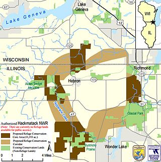
The Hackmatack National Wildlife Refuge is a United States national wildlife refuge that will include noncontiguous properties, especially tallgrass prairie patches, wetland properties, and oak savanna parcels, located in the northwestern region of the Chicago metropolitan area and the southern part of the Milwaukee area. The refuge's boundaries encompass parts of McHenry County, Illinois, and Walworth County, Wisconsin. The refuge will be operated by the United States Fish and Wildlife Service, known as USFWS. 85 percent of the refuge will be in Illinois, and 15 percent in Wisconsin.

Lake Mattamuskeet Pump Station, also known as Mattamuskeet Lodge, is a historic pumping station building located on Lake Mattamuskeet at the Mattamuskeet National Wildlife Refuge near Swan Quarter, Hyde County, North Carolina. It was built in 1911, and is a three-story 14,977 square foot brick building. In 1934, it was remodeled as headquarters building and hotel accommodation for visitors after acquisition of Lake Mattamuskeet by the U. S. Government. The building contains 38 rooms and is connected to a 120-foot-high tower with stairway.

The Mountain Bogs National Wildlife Refuge is a federally protected wildlife refuge located within multiple western North Carolina counties, United States. The refuge has a total area of over 7,000 acres (28 km2) consisting of fee title and conservation easements on privately owned property. In order to respect the wishes of the landowner, and protect sensitive habitat, the refuge is currently not open to the public.


